Charlier (Martian Crater)
 From Handwiki
 Short description: Crater on Mars
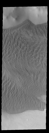 THEMIS image of Charlier crater showing part of the large sand sheet with surface dune forms on the crater floor | |
| Planet | Mars |
|---|---|
| Region | Mare Australe quadrangle |
| Coordinates | Coordinates: 68°34′S 168°40′W / 68.56°S 168.67°W |
| Diameter | 106.28 km |
| Discoverer | Mariner 9 |
Charlier is a crater in the Mare Australe quadrangle of Mars. The crater is located at 68.56°S latitude and 168.67°W longitude. It is 106.28 km in diameter and was named after Carl Charlier, a Swedish astronomer. Its name was approved in 1973.[1]
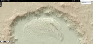
This topographic map was created using Mars Orbiter Laser Altimeter (MOLA) technology on the Mars Global Surveyor spacecraft. This image is a screenshot of RedMapper's website and shows the north rim of Charlier crater.
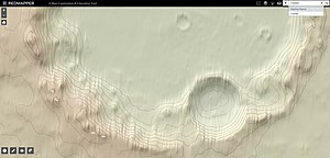
This topographic map was created using Mars Orbiter Laser Altimeter (MOLA) technology on the Mars Global Surveyor spacecraft. This image is a screenshot of RedMapper's website and shows the south rim of Charlier crater.
See also
- List of craters on Mars: A-G
References
- ↑ "Charlier". Gazetteer of Planetary Nomenclature (USGS). International Astronomical Union. http://planetarynames.wr.usgs.gov/Feature/1154.
External links
 |
Categories: [Impact craters on Mars] [Mare Australe quadrangle]
↧ Download as ZWI file | Last modified: 08/15/2022 12:48:39 | 3 views
☰ Source: https://handwiki.org/wiki/Astronomy:Charlier_(Martian_crater) | License: CC BY-SA 3.0
 ZWI signed:
ZWI viewer
by the  KSF
KSF