Akaroa
 From Handwiki
Akaroa Port Louis-Philippe | |
|---|---|
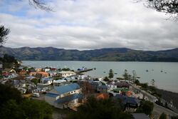 Akaroa township and its Main Wharf | |
| Lua error in Module:Location_map at line 522: Unable to find the specified location map definition: "Module:Location map/data/New Zealand Banks Peninsula" does not exist. | |
| Coordinates: [ ⚑ ] : 43°48′15″S 172°58′00″E / 43.80417°S 172.9666667°E | |
| Country | New Zealand |
| Region | Canterbury Region |
| District | Christchurch City |
| Ward | Banks Peninsula |
| European settlement | 18 August 1840 |
| Founded by | Jean François Langlois |
| Area [1] | |
| • Total | 2.03 km2 (0.78 sq mi) |
| Population (Template:NZ population data 2018 SA2)Template:NZ population data 2018 SA2 | |
| • Total | Template:NZ population data 2,018 SA2 |
| Postcode | 7520 |
| Local iwi | Ngāi Tahu |
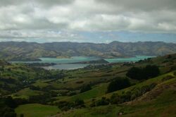
Akaroa is a small town on Banks Peninsula in the Canterbury Region of the South Island of New Zealand, situated within a harbour of the same name. The name Akaroa is Kāi Tahu Māori for "Long Harbour", which would be spelled Whangaroa in standard Māori. The area was also named Port Louis-Philippe by French settlers after the reigning French king Louis Philippe I.
The town is 84 kilometres (52 mi) by road from Christchurch and is the terminus of State Highway 75. It is set on a sheltered harbour and is overlooked and surrounded by the remnants of an eruptive centre of the miocene Banks Peninsula Volcano.[2] Akaroa is entirely dependent upon rainfall on the hills.[3]
Akaroa is a popular resort town. Many Hector's dolphins may be found within the harbour, and 'swim with the dolphins' boat tours are a major tourist attraction.[4][5] Akaroa has become a popular cruise ship destination after the 2011 Canterbury Earthquakes damaged the port of Lyttelton. In the summer of 2009-10, Akaroa was visited by seven cruise ships. This has increased to ninety cruise ships in 2019 and 2020. The numbers reduced to 19 cruise ships in 2022 with the opening of Lyttelton cruise ship berth.[6][7][8]
Ōnuku marae, a marae (tribal meeting ground) of Ngāi Tahu and its Ōnuku Rūnanga branch, is located in Akaroa.[9] It includes the Karaweko wharenui (meeting house).[10]
History
In 1830, the Māori settlement at Takapūneke, just east of the current town of Akaroa, became the scene of a notorious incident. The captain of the British brig Elizabeth, John Stewart, helped North Island Ngāti Toa chief, Te Rauparaha, to capture the local Kāi Tahu chief, Tama-i-hara-nui, his wife Te Whe and his young daughter, Roimata. The settlement of Takapūneke was sacked. Concern over the complicity of John Stewart, amongst other lawlessness among Europeans in New Zealand, led to the appointment of an official British Resident James Busby to New Zealand in 1832 – the first step in the British involvement that led to the Treaty of Waitangi.[12]
In early 1832, Te Rauparaha, fresh from his successful three-month siege of Kaiapoi Pā, took the pā on the Ōnawe Peninsula at the head of Akaroa Harbour. There were an estimated 400 Kāi Tahu in the pā and most were killed, with only the strongest taken as slaves.[13]
The earliest European settlers used Akaroa as a whaling base. Akaroa is now one of the few whaling bases in New Zealand that still exists as a town.[14]
French settlement
.JPG)
In 1838 Captain Jean François Langlois made a provisional purchase of land in "the greater Banks Peninsula" from 12 Kāi Tahu chiefs.[15] A deposit of commodities in the value of £6 was paid and a further £234 worth of commodities was to be paid at a later period.[16]
On his return to France, Langlois advertised for settlers to go to New Zealand, and ceded his interest in the land to the Nanto-Bordelaise Company, of which he became a part-owner. On 9 March 1840, 63 emigrants left from Rochefort. The settlers embarked for New Zealand on the Comte de Paris, an old man-of-war ship given to them by the French government. The Comte de Paris and its companion ship the Aube, captained by Commodore Charles-François Lavaud (fr), arrived in the Bay of Islands in the North Island on 11 July 1840, where they discovered that during their voyage the British had claimed Banks Peninsula. The French arrived in Akaroa Harbour on 18 August and established a settlement centred on the present-day site of Akaroa. Bishop Pompallier established his first European station in Akaroa in 1840 as the French immigrants were all nominally Catholic. However, he closed the station in disgust, due to the religious apathy of the French immigrants.[17]
Given that the French colonists had set out for New Zealand on the assumption that they owned the land, the New Zealand authorities made a grant of 30,000 acres to the Nanto-Bordelaise Company, which ceded all rights to the peninsula for £4,500.[16]
Before 1840, the area of the current Akaroa town was also known as Wangaloa. The French at first called their settlement Port Louis-Philippe in honour of Louis Philippe I, who reigned as King of the French from 1830 to 1848.[18]
The area still shows a French influence, prominent in many local place names.[19] It is the oldest town in Canterbury and one of the most historic places in New Zealand.[14]
British settlement
After being informed of the French intention to colonise Akaroa and to further its use as a whaling port, the Lieutenant-Governor of New Zealand, Captain William Hobson, sent the ship HMS Britomart to proclaim sovereignty over the area for the British Crown. HMS Britomart arrived in Akaroa on 16 August 1840, although the captain's log shows the arrival date as 11 August. Captain Stanley raised the British flag, and held a court at each of the occupied settlements, to convince the French that the area was indeed under British control.[16] A monument at the eastern edge of the town commemorates the British arrival.
James Robinson Clough, also known as Jimmy Robinson, had arrived at Akaroa several years before. He acted as interpreter for Captain Owen Stanley at the flag-raising of 1840, and was the first European to travel up the Avon River in 1843. Clough's descendants are still prominent on the Peninsula today.
British immigrants settled in both Akaroa and German Bay (Takamatua), along with many German farmers, who set up dairy, sheep and cocksfoot (Dactylis glomerata) farms. The great majority of the artifacts currently held at Akaroa Museum are of the early farming community and their way of life at the time.
Arriving from England in April 1850, the Monarch, needing repairs, sailed into Akaroa Harbour. It was bound for Auckland however forty of the passengers decided to stay in Akaroa.[20] The British immigrants settled at the southern end of Akaroa with the French living at the northern end with a small bay separating the two.[21]
Akaroa was described in 1854 as “altogether very like a small seaside village in England”. In 1878, there were only ten French born residents in the town of Akaroa out of a population of 642 people. A further 27 French born people lived outside the town boundaries.[20]
Businesses grew in Akaroa and by 1883 there were five builders, four confectioners, eight general stores, five milk-sellers, four shoemakers, two bankers, five milliners and five blacksmiths.[20]
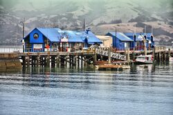
Daly's wharf was built between 1863 and 1865 and refurbished in 1914.[22] Located at the end of Rue Balguerie, it has been used by coastal ships and fishing boats. At the end of the wharf, an octagonal building with a turret roof was built by 1932.[23]
The main wharf at Akaroa was built in 1887.[24] Plans were made in 2022 to rebuild the main wharf in the same position that it currently is, as it was nearing the end of its useable life.[25] The rebuild is expected to cost $19.1 million and be completed by 30 June 2025.[26]
Demographics
Akaroa is defined by Statistics New Zealand as a rural settlement, and covers 2.03 km2 (0.78 sq mi).[1] It had an estimated population of Template:NZ population data 2018 SA2 as of Template:NZ population data 2018 SA2 with a population density of Formatting error: invalid input when rounding people per km2.
| Historical population | ||
|---|---|---|
| Year | Pop. | ±% p.a. |
| 2006 | 591 | — |
| 2013 | 645 | +1.26% |
| 2018 | 756 | +3.23% |
| Source: [27] | ||
Akaroa had a population of 756 at the 2018 New Zealand census, an increase of 111 people (17.2%) since the 2013 census, and an increase of 165 people (27.9%) since the 2006 census. There were 288 households. There were 375 males and 378 females, giving a sex ratio of 0.99 males per female. The median age was 55.3 years (compared with 37.4 years nationally), with 63 people (8.3%) aged under 15 years, 108 (14.3%) aged 15 to 29, 339 (44.8%) aged 30 to 64, and 240 (31.7%) aged 65 or older.
Ethnicities were 82.5% European/Pākehā, 6.0% Māori, 0.8% Pacific peoples, 11.9% Asian, and 2.8% other ethnicities (totals add to more than 100% since people could identify with multiple ethnicities).
The proportion of people born overseas was 34.9%, compared with 27.1% nationally.
Although some people objected to giving their religion, 44.4% had no religion, 34.9% were Christian, 1.6% were Hindu, 4.8% were Muslim, 1.6% were Buddhist and 4.4% had other religions.
Of those at least 15 years old, 126 (18.2%) people had a bachelor or higher degree, and 87 (12.6%) people had no formal qualifications. The median income was $31,800, compared with $31,800 nationally. The employment status of those at least 15 was that 327 (47.2%) people were employed full-time, 111 (16.0%) were part-time, and 9 (1.3%) were unemployed.[27]
Education
Akaroa's first primary school opened in 1857, and the first high school followed in 1883. The high school was for boys only in the first year but became co-educational in the second year. However, in 1900 it closed due to a lack of paying students. The next year, it re-opened as a free District High School. It moved to the current site in 1935. In 2007, the primary school was merged with it to form Akaroa Area School.[28] This is now a co-educational composite school covering years 1 to 13,[29] with a roll of 128 as of July 2022.[30]
Museum
The Akaroa museum, first opened in 1964, concentrates on the history of Akaroa and the Banks Peninsula. It is located at 71 Rue Lavaud and includes within the museum complex: the 1850s customs house, the 1878 court house and the 1840s Langlois-Eteveneaux cottage.[31][32][33] In 2023, the museum put on an exhibition called Catching Shadows which displayed a photographic history of Banks Peninsula starting in the early 1840s.[34]
Akaroa lighthouse
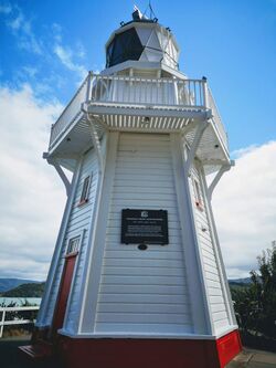
The Akaroa lighthouse has sat at Cemetery Point within the township since 1980. For the 100 years prior to that, it sat 270 feet above sea level on the headland of Akaroa heads. The original site was chosen in 1875 and in 1877 the lens and mount were ordered from France and the mechanism from Scotland. The road to the lighthouse had to be blasted out of solid rock and took ten months to complete. Construction of the lighthouse finally began in 1879. Unfortunately, a southerly storm demolished the framework completely and work had to start from scratch again, this time with a stronger design, The 28-foot-tall light house was completed in 1880 and when operating, its light could be seen 37 kilometres away. A telephone was installed in the lighthouse in 1885, and a kerosene generator was installed in 1935 automating the lighthouse. This was converted to diesel in 1951. In 1977 an automatic lighthouse was built to replace the original staffed lighthouse. In 1980 the original lighthouse was moved in pieces and then reassembled in its current position within the town of Akaroa. The Akaroa lighthouse in open for viewing on Sundays and on days when cruise ships visit the town.[35][36][37][38]
Churches
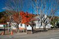
Onuku church
This church had its foundation stone laid in November 1876 and was completed in 1878. It is located at the Onuku marae. It was built out of timber with a pitched shingle roof. It has a bell turret and room for 60 parishioners. After falling into disrepair around 1939, work was completed to restore the church and add traditional carved panels to the porch. Services were held regularly until 1963.[39]
Saint Patrick's Catholic church
This was the third Catholic church to be built in Akaroa, replacing the two earlier churches. It was designed by Christchurch architects Benjamin Mountfort and Maxwell Bury and built in 1865 out of timber. A porch was added in 1886 and a bell tower in 1893. A stained glass window depicting the crucifixion was added in 1930.[40]
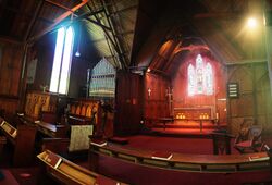
Saint Peter's Anglican church
Saint Peter's Anglican church was built out of timber in the Gothic revival style and was completed in 1863. It replaced the previous Anglican church which was built eleven years earlier in 1852. A pipe organ was added in 1869. Benjamin Mountfort designed the transepts and chancel in 1877.[41][42]
Trinity Presbyterian church
The Trinity Presbyterian church was completed in 1886, thirty years after the first Presbyterian services were held in a private home. Built in the Gothic revival style with a steep roof, it was designed by Christchurch architect, John Whitelaw. In 1912, a church hall was added. It was listed by Heritage New Zealand as a category two historic place in 1990.[43][44]
.jpg)
Onuku church
,_Akaroa.jpg)
Saint Patrick's Catholic church
.jpg)
Saint Peter's Anglican church
Trinity Presbyterian church
Notable residents
- Jessie Buckland (1878–1939), photographer[45]
- John Buckland (1844–1909), politician[46][47]
- Bob Parker (born 1953), former mayor of Banks Peninsula and former resident[48]
- William Penlington (1832–1899), sawmiller, builder and mayor of Akaroa[49]
- William Penlington (1890–1982), school principal and educationalist[50]
- Hugh Wilson (born 1945), botanist living at Hinewai Reserve over the hill from Akaroa[48]
- Frank Worsley (1872–1943), sailor and explorer who served on Ernest Shackleton's Imperial Trans-Antarctic Expedition of 1914–1916, as captain of the Endurance[51]
Notes
- ↑ 1.0 1.1 "ArcGIS Web Application". https://statsnz.maps.arcgis.com/apps/webappviewer/index.html?id=6f49867abe464f86ac7526552fe19787.
- ↑ Royal Society & February 1958, pp. 207ff.
- ↑ "Akaroa water supply". https://www.ccc.govt.nz/services/water-and-drainage/water-supply/water-supply-schemes/akaroa-water-supply/.
- ↑ "Swimming with dolphins in Akaroa tops NZ must-dos". ODT (ODT). 28 February 2017. https://www.odt.co.nz/news/national/swimming-dolphins-akaroa-tops-nz-must-dos.
- ↑ Mitchell, Charlie (18 September 2016). "Ban on new dolphin tourism ventures in Akaroa Harbour". Stuff. http://www.stuff.co.nz/environment/84388112/Ban-on-new-dolphin-tourism-ventures-in-Akaroa-Harbour.
- ↑ "From 90 to 19: Drop in number of cruise ships returning to Banks Peninsula this summer" (in en-nz). 2022-05-07. https://www.rnz.co.nz/news/national/466645/from-90-to-19-drop-in-number-of-cruise-ships-returning-to-banks-peninsula-this-summer.
- ↑ "Cruise ship impact on Akaroa needs more research report finds" (in en-nz). 2019-10-13. https://www.rnz.co.nz/news/national/400906/cruise-ship-impact-on-akaroa-needs-more-research-report-finds.
- ↑ Allott, Amber (2022-10-21). "Fewer Hector's dolphins in harbour after cruise ship activity ramped up, study finds" (in en). https://www.stuff.co.nz/environment/130247929/fewer-hectors-dolphins-in-harbour-after-cruise-ship-activity-ramped-up-study-finds.
- ↑ "Te Kāhui Māngai directory". Te Puni Kōkiri. http://www.tkm.govt.nz/.
- ↑ "Māori Maps". Te Potiki National Trust. https://maorimaps.com/map.
- ↑ "Saint Peter's Anglican Church (1864) – Akaroa – New Zealand". http://www.akaroa.com/places-worship/saint-peters-anglican-church-1864.
- ↑ "Captain Stewart and the Elizabeth". Ministry for Culture and Heritage. 20 December 2012. https://nzhistory.govt.nz/culture/maori-european-contact-pre-1840/captain-stewart-and-the-elizabeth.
- ↑ Ogilvie 2010, p. 13.
- ↑ 14.0 14.1 Ogilvie 2010, p. 20.
- ↑ "French colonists in Akaroa, South Island". http://history-nz.org/colonisation4.html.
- ↑ 16.0 16.1 16.2 Andersen, Johannes C.. "The Mission of the Britomart at Akaroa, in August, 1840". The New Zealand Institute. http://christchurchcitylibraries.com/Heritage/Publications/Akaroa/MissionoftheBritomart/MissionoftheBritomart.pdf.
- ↑ King, Michael (2003). The Penguin History of New Zealand. New Zealand: Penguin. pp. 170–1.
- ↑ Reed, A. W. (2010). Peter Dowling. ed. Place Names of New Zealand. Rosedale, North Shore: Raupo. p. 19. ISBN 9780143204107.
- ↑ "SettlementatAkaroa". http://freepages.genealogy.rootsweb.com/~ourstuff/SettlementatAkaroa.htm.
- ↑ 20.0 20.1 20.2 John Wilson, Louise Beaumont (June 2009). "Akaroa Historical Overview". https://ccc.govt.nz/assets/Documents/The-Council/Plans-Strategies-Policies-Bylaws/Plans/district-plan/banks-peninsula/AkaroaHistoricalOverview-part-1.pdf.
- ↑ Turner, Gwenda (1977). Akaroa. Dunedin, New Zealand: John McIndoe. pp. 14. ISBN 0-908565-41-0.
- ↑ "DALY’S WHARF". http://www.akaroacivictrust.co.nz/fastpage/fpengine.php/templateid/56/menuid/1/tempidx/2/catid/1/editstatus/.
- ↑ "DALY’S WHARF, SHELTER AND SETTING 1A RUE BALGUERIE, AKAROA". 15 January 2015. https://districtplan.ccc.govt.nz/Images/DistrictPlanImages/Statement of Significance/Banks Peninsula/HID 1210.pdf.
- ↑ "Akaroa Wharf" (in en-GB). https://ccc.govt.nz/the-council/future-projects/major-facilities/akaroa-wharf/.
- ↑ "$19.1 million Akaroa Wharf plan progresses" (in en). 2022-05-13. https://www.odt.co.nz/star-news/star-christchurch/191-million-akaroa-wharf-plan-progresses.
- ↑ "Akaroa Wharf" (in en-GB). https://ccc.govt.nz/the-council/future-projects/major-facilities/akaroa-wharf/.
- ↑ 27.0 27.1 "Statistical area 1 dataset for 2018 Census". Statistics New Zealand. March 2020. Akaroa (333500). https://www.stats.govt.nz/information-releases/statistical-area-1-dataset-for-2018-census-updated-march-2020. 2018 Census place summary: Akaroa
- ↑ "Brief School History". Akaroa Area School. http://akaroa.school.nz/location-map/.
- ↑ Template:TKI
- ↑ "New Zealand Schools Directory". New Zealand Ministry of Education. https://www.educationcounts.govt.nz/data-services/directories/list-of-nz-schools.
- ↑ "Akaroa Museum | Christchurch NZ" (in en-NZ). 2019-12-02. https://christchurch.co.nz/listing/akaroa-museum/.
- ↑ "Organisation details | Museums Aotearoa". https://www.museumsaotearoa.org.nz/museums-directory/23263/details.
- ↑ "Home : Akaroa Museum". https://akaroamuseum.org.nz/.
- ↑ "Tracing a century of photography on Banks Peninsula" (in en-GB). 2023-04-18. https://newsline.ccc.govt.nz/news/story/tracing-a-century-of-photography-on-banks-peninsula.
- ↑ "Akaroa Lighthouse" (in en-NZ). https://www.heritage.org.nz/list-details/3343/Akaroa Lighthouse.
- ↑ "AKAROA LIGHTHOUSE". http://www.akaroacivictrust.co.nz/fastpage/fpengine.php/link/1/templateid/76/tempidx/2/menuid/1.
- ↑ "Akaroa Head" (in en-nz). https://www.doc.govt.nz/parks-and-recreation/places-to-go/canterbury/places/banks-peninsula-area/historic-akaroa-head/.
- ↑ "Akaroa Lighthouse Preservation Society » Akaroa & The Bays". https://www.akaroa.com/members/akaroa-lighthouse-preservation-society/.
- ↑ "TE WHARE KARAKIA O ŌNUKU AND SETTING – 392 ONUKU ROAD, AKAROA". 8 August 2014. https://districtplan.ccc.govt.nz/Images/DistrictPlanImages/Statement of Significance/Banks Peninsula/HID 683.pdf.
- ↑ "ST PATRICK’S ROMAN CATHOLIC CHURCH". http://www.akaroacivictrust.co.nz/fastpage/fpengine.php/templateid/15/menuid/1/tempidx/6/catid/1/editstatus/.
- ↑ "ST PETER’S ANGLICAN CHURCH". http://www.akaroacivictrust.co.nz/fastpage/fpengine.php/templateid/16/menuid/1/tempidx/6/catid/1/editstatus/.
- ↑ "St Peter's Church (Anglican)" (in en-NZ). https://www.heritage.org.nz/list-details/267/St Peter's Church (Anglican).
- ↑ "TRINITY PRESBYTERIAN CHURCH". http://www.akaroacivictrust.co.nz/fastpage/fpengine.php/templateid/62/menuid/1/tempidx/2/link/1.
- ↑ "Trinity Church (Presbyterian)" (in en-NZ). https://www.heritage.org.nz/list-details/5288/Trinity Church (Presbyterian).
- ↑ Main, William. "Jessie Lillian Buckland". Dictionary of New Zealand Biography. Ministry for Culture and Heritage. https://teara.govt.nz/en/biographies/2b47. Retrieved 23 April 2017.
- ↑ "Buckland, Jessie Lillian" (in en). https://teara.govt.nz/en/biographies/2b47/buckland-jessie-lillian.
- ↑ "Buckland, Jessie Lillian, 1878–1939" (in en-nz). 1 January 1878. https://natlib.govt.nz/records/22356136.
- ↑ 48.0 48.1 Easther, Elisabeth (31 January 2014). "Kia ora: Akaroa". The New Zealand Herald (Auckland). http://www.nzherald.co.nz/travel/news/article.cfm?c_id=7&objectid=11193402.
- ↑ Template:Macdonald Dictionary
- ↑ Boyd, Mary. "William Arthur Greener Penlington". Dictionary of New Zealand Biography. Ministry for Culture and Heritage. https://teara.govt.nz/en/biographies/4p7.
- ↑ Dennerly, P. Y.. "Worsley, Frank Arthur". Dictionary of New Zealand Biography. Ministry for Culture and Heritage. https://teara.govt.nz/en/biographies/3w28.
References
- Ogilvie, Gordon (2010). Banks Peninsula : Cradle of Canterbury (3rd ed.). Phillips & King Publishers. ISBN 978-0-9583315-7-9.
- The Royal Society of New Zealand (February 1958). New Zealand Journal of Geology and Geophysics. The Royal Society of New Zealand. p. 207. https://archive.org/details/bub_gb_KKg4AAAAIAAJ.
External links
 Akaroa travel guide from Wikivoyage
- Akaroa official website
- Akaroa Civic Trust
 |
Categories: [Miocene volcanoes]
↧ Download as ZWI file | Last modified: 12/04/2023 04:54:55 | 2 views
☰ Source: https://handwiki.org/wiki/Place:Akaroa | License: CC BY-SA 3.0
 ZWI signed: