Sadat (City)
 From Handwiki
 [ ⚑ ] 30°22′52″N 30°31′36″E / 30.3811°N 30.5266°E
Sadat السادات | |
|---|---|
City | |
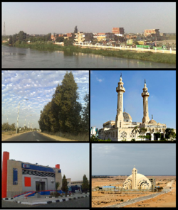 Images from top, left to right: Skyline of Kafr Daoud Village, Shibin El Kom-Sadat Road, Abd El-Aziz Ezz Mosque, CIB Bank, Virgin Mary Church | |
 Flag  Seal | |
 Sadat Location in Egypt | |
| Coordinates: [ ⚑ ] 30°22′52″N 30°31′36″E / 30.3811°N 30.5266°E | |
| Country | |
| Governorate | Monufia |
| Established | 1978 |
| Area | |
| • Total | 241 sq mi (625 km2) |
| Population (2010) | |
| • Total | 79,000 |
| Time zone | UTC+2 (EST) |
| Area code(s) | +2 048 |
Sadat (Arabic: السادات El Sādāt Egyptian Arabic pronunciation: [essæˈdæːt]) is a city in the Monufia Governorate, Egypt. It is named after late president Anwar Sadat. The city is located 94 kilometres (58 mi) northwest of Cairo. It is a first generation new urban community and one of the largest industrial cities in the country.[1]
The city is surrounded by a 350 km2 green belt, which has earned it a place in the top ten list of environmentally friendly industrial cities in the Middle East.
Industry
Sadat City has industry in a variety of sectors and in 2017, more land was slated and offered for industrial investment in Sadat.[2]
Climate
Köppen-Geiger climate classification system classifies its climate as hot desert (BWh).
Script error: No such module "weather box".
See also
- List of cities and towns in Egypt
- Anwar Sadat
- Beheira governorate
- 6th of October City
- New Cairo
- New Borg El Arab
- Greater Cairo
References
- ↑ "Sadat City Investor's Association". http://www.sadat-city.com/en/default.asp.
- ↑ Ayyad, Mohamed (December 31, 2016). "Industry Ministry to offer new lands for industrial investment in 2017". Daily News Egypt. http://www.dailynewsegypt.com/2016/12/31/industry-ministry-offer-new-lands-industrial-investment-2017/.
- ↑ "Climate: Madinat al Sadat - Climate graph, Temperature graph, Climate table". climate-data.org. http://en.climate-data.org/location/475946/. Retrieved 13 August 2013.
External links
 |
Categories: [Cities in Egypt]
↧ Download as ZWI file | Last modified: 07/29/2024 06:05:30 | 3 views
☰ Source: https://handwiki.org/wiki/Place:Sadat_(city) | License: CC BY-SA 3.0