Guarujá Formation
 From Handwiki
 | Guarujá Formation Stratigraphic range: Early Albian ~113–108 Ma PreЄ
Є
O
S
D
C
P
T
J
K
Pg
N
↓ | |
|---|---|
| Type | Geological formation |
| Unit of | Camburi Group |
| Underlies | Itajaí-Açu Fm., Juréia Fm. |
| Overlies | Ariri Formation |
| Thickness | up to 2,500 m (8,200 ft) |
| Lithology | |
| Primary | Limestone |
| Other | Marl |
| Location | |
| Coordinates | [ ⚑ ] : 26°6′S 43°43′W / 26.1°S 43.717°W |
| Region | Santos Basin, South Atlantic |
| Country | |
| Type section | |
| Named for | Guarujá |
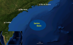 Location of the Santos Basin | |
The Guarujá Formation (Portuguese: Formacão Guarujá) is a geological formation of the Santos Basin offshore of the Brazil ian states of Rio de Janeiro, São Paulo, Paraná and Santa Catarina. The predominantly calcarenite formation with marls dates to the Early Cretaceous period; Early Albian epoch and has a maximum thickness of 2,500 metres (8,200 ft). The formation is the second-most important post-salt reservoir rock of the Santos Basin.
Etymology
The formation is named after the city of Guarujá, São Paulo.
Description
The Guarujá Formation is 832 to 2,500 metres (2,730 to 8,202 ft) thick,[1] and consists of oolitic calcarenites, which laterally grade to greyish ochre and brownish grey calcilutites and grey marls. These facies are interbedded with the alluvial clastics of the Florianópolis Formation. The Guarujá name is restricted to the lowest limestone intercalation, previously named Lower Guarujá by Ojeda and Ahranha in Pereira and Feijó (1994). The microfacies indicate a tidal flat to shallow lagoon and open carbonate platform depositional environment. The age based on planktonic foraminifera and pollen is Early Albian.[2]
Petroleum geology
The formation is the second-most important post-salt reservoir rock of the Santos Basin,[3] after the Itajaí-Açu Formation.[4][5]
| Field | Year | Operator | Reserves (in place, million barrels) | Reserves (in place, million m3) | Notes |
|---|---|---|---|---|---|
| Cavalo Marinho | 2001 | Petrobras | 25.04 | 3.981 | [4][6]
|
| Caravela | 1992 | Petrobras | 48.81 | 7.760 | [4][7]
|
| Caravela Sul | 1991 | Petrobras | 5 | 0.79 | [4]
|
| Coral | 1990 | Petrobras | 22.57 | 3.588 | [4][8]
|
| Estrela do Mar | 1990 | Petrobras | 15.16 | 2.410 | [4][9]
|
| Tubarão | 1988 | Petrobras | 30 | 4.8 | [10]
|
See also
- Campos Basin
References
- ↑ Kiang Chang et al., 2008, p.32
- ↑ Clemente, 2013, p.22
- ↑ Contreras, 2011, p.34
- ↑ 4.0 4.1 4.2 4.3 4.4 4.5 "Santos Basin Fields". http://www.karoon.com.br/en/index.php/proyecto-brasil/?img=6&id=38.
- ↑ Vieira, 2007, p.9
- ↑ Juarez, 2013, p.14
- ↑ ANP Yearbook, 2014, p.30
- ↑ Coral Field: Case History in Oil Producing Albian Carbonates in Santos Basin, Brazil
- ↑ Estrela do Mar, Cavalo Marinho oil output by 2007
- ↑ Juarez, 2013, p.11
Bibliography
- ANP, .. 2014. Oil, natural gas and biofuels - Statistical Yearbook, 1–73. ANP.
- Clemente, Pilar. 2013. Petroleum geology of the Campos and Santos basins, Lower Cretaceous Brazilian sector of the South Atlantic margin, 1–33. Danmarks Tekniske Universitet. Accessed 2017-09-04.
- Contreras, Jorham. 2011. Seismo-stratigraphy and numerical basin modeling of the southern Brazilian continental margin (Campos, Santos, and Pelotas basins) (PhD thesis), 1–171. Ruprecht-Karls-Universität Heidelberg. Accessed 2017-09-04.
- Juarez Feijó, Fávio. 2013. Santos Basin: 40 Years from Shallow to Deep to Ultra-Deep Water. Search and Discovery 10553. 1–49. Accessed 2017-09-04.
- Kiang Chang, Hung; Mario Luis Assine; Fernando Santos Corrêa; Julio Setsuo Tinen; Alexandre Campane Vidal, and Luzia Koike. 2008. Sistemas petrolíferos e modelos de acumulação de hidrocarbonetos na Bacia de Santos. Revista Brasileira de Geociências 38. 29–46. Accessed 2017-09-04.
- Vieira, Juliana. 2007. Brazil Round 9 - Santos Basin, 1–73. ANP. Accessed 2017-09-04.
 |  |
Categories: [Albian Stage] [Limestone formations] [Shallow marine deposits] [Reservoir rock formations]
↧ Download as ZWI file | Last modified: 09/15/2024 23:07:51 | 3 views
☰ Source: https://handwiki.org/wiki/Earth:Guarujá_Formation | License: CC BY-SA 3.0