Falls of the Ohio
 From Citizendium - Reading time: 1 min


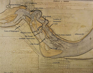
A ridge of rock crosses the Ohio River, at Louisville, Kentucky, known as the Falls of the Ohio. It was the only navigational obstacle on the river. Passengers and cargo had to be portaged, until a canal was constructed.
Licensed under CC BY-SA 3.0 | Source: https://citizendium.org/wiki/Falls_of_the_Ohio24 views | Status: cached on November 25 2025 16:06:20↧ Download this article as ZWI file
 KSF
KSF