Ontario Line
 From Citizendium - Reading time: 3 min

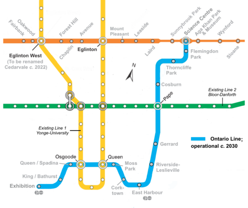
The Ontario Line is a new subway line under construction in Toronto, Ontario slated to be completed by around 2030. Its construction was one of platform promises of Conservative Party leader Doug Ford, during Ontario's 2016 election. He promised to replace a less ambitious more traditional line initiated by his rivals from the then ruling Liberal Party.
Comparison with the Downtown Relief Line[edit]
Toronto's first subway line ran approximately 6 kilometres under Yonge Street, from Union Station to Eglinton Avenue. This segment was completed in 1954. Over the years the route was extended, at both ends. with the Yonge portion eventually being extended another 8 kilometres, to Finch Avenue. The Finch Avenue terminus connects with bus routes from both within Toronto, and from neighbouring municipalities.
While the route's extension from Union Station curves back northwest, to serving riders from that quadrant, ridership on the original Yonge portion started to reach and exceed the line's capacity. During its busiest periods southbound riders waiting on the platforms in the middle of the route could find that there was no room to board trains as they had already been filled with riders from the more northerly stations.
Plans for a parallel north-south route, east of Yonge, had been worked on for decades, without any particular plans finding funding, until the Liberals announced a plan for a route that would run from Pape Station at Pape and Danforth avenues, to Osgoode Station, at Queen Street and University Avenue. This first phase was budgeted at approximately $6 billion in 2016 Canadian dollars.
Ford's Conservatives promised a longer route, from the future Ontario Science Centre Station at Eglinton Avenue and Don Mills Road, to a station named Ontario Place Station, at the Canadian National Exhibition grounds. Both terminii were named after large projects completed by a previous Conservative government, in 1967 and 1973. Both high profile projects were named after the Province, so the entire route was going to be named after the Province.
Ford promised taxpayers that the route he proposed would be longer than the planned route it superceded, would be completed more quickly than the route it superceded, and would cost less per kilometer. He based this promise on using newer technology than the standard heavy rail vehicles used on the earlier subway routes.
Ford's plan was going to use then unspecified smaller lighter rolling stock, and acheive the same carrying capacity by running trainsets with shorter time between trains. This would be achieved by using automated trains with robotic automatic train control.
Role of the Province[edit]
While the Provincial government had helped fund Toronto's first two rapid transit routes, it had not taken any role in the design or implementation. When the city built its third rapid transit line, from the eastern terminus of its east-west route, at Kennedy Station, to the Scarborough Town Centre, it original plan had been for this to be a Light Rail line, using conventional streetcars, on a dedicated right of way. In this case the Provincial funding depended upon the city agreeing to use new experimental vehicles, with linear induction motors, that the Province had helped fund.
The Province played a larger role in the plans for a later plan to build a half dozen light rail lines within the city, creating a new Provincial agency, Metrolinks, for this purpose. And the Province continued this trend with both the now superceded Downtown Relief Line and the ONtario Line. While Toronto's own Toronto Transit Commission will have operational control, once the line is complete, the Province awarded the construction contracts, and will contract out the line's maintenance.
Stations[edit]
- Science Centre Station - Connects with the east-west Eglinton Crosstown LRT
- Flemingdon Park Station
- Thorncliffe Park Station
- Cosburn Station
- Pape Station - Connects with the east-west Bloor Danforth Line
- Gerrard Station - Connects with the GO Transit regional commuter rail system
- Riverside–Leslieville Station
- East Harbour Station - Connects with the GO Transit regional commuter rail system
- Corktown Station
- Moss Park Station
- Queen Station - Connects with the north-south Yonge University Line
- Osgoode Station - Connects with the north-south Yonge University Line
- Queen–Spadina Station
- King–Bathurst Station
- Ontario Place Station - Connects with the GO Transit regional commuter rail system
 KSF
KSF