Lamé (crater)
Topic: Astronomy
 From HandWiki - Reading time: 2 min
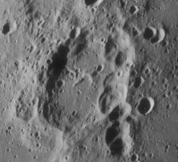
 Oblique Lunar Orbiter 4 image | |
| Diameter | 84 km |
|---|---|
| Depth | 3.3 km |
| Colongitude | 296° at sunrise |

Lamé is a lunar impact crater located astride the northeast rim of the crater Langrenus, to the east of Mare Fecunditatis. The eastern crater rim appears overlaid by a series of overlapping craters that form an intermittent chain flowing nearly a hundred kilometers to the south. The crater rim protrudes only slightly above the surrounding terrain, but it has a significant rampart where the rim lies within Vendelinus. In the middle of the floor is a slight ridge, forming a central peak.
On some older maps this crater was called Smith. It was previously designated Vendelinus C before being renamed by the IAU.
Satellite craters
By convention these features are identified on lunar maps by placing the letter on the side of the crater midpoint that is closest to Lamé.
| Lamé | Latitude | Longitude | Diameter |
|---|---|---|---|
| E | 13.9° S | 66.8° E | 11 km |
| F | 13.9° S | 66.4° E | 18 km |
| G | 15.4° S | 65.5° E | 26 km |
| H | 15.8° S | 68.2° E | 12 km |
| J | 14.3° S | 65.7° E | 18 km |
| K | 13.3° S | 64.2° E | 8 km |
| L | 14.4° S | 68.6° E | 6 km |
| M | 15.8° S | 66.5° E | 13 km |
| N | 12.8° S | 67.1° E | 9 km |
| T | 12.5° S | 66.5° E | 11 km |
| W | 13.1° S | 65.9° E | 6 km |
| Z | 15.9° S | 65.9° E | 17 km |
References
- Andersson, L. E.; Whitaker, E. A. (1982). NASA Catalogue of Lunar Nomenclature. NASA RP-1097.
- Blue, Jennifer (July 25, 2007). "Gazetteer of Planetary Nomenclature". USGS. http://planetarynames.wr.usgs.gov/.
- Bussey, B.; Spudis, P. (2004). The Clementine Atlas of the Moon. New York: Cambridge University Press. ISBN 978-0-521-81528-4.
- Cocks, Elijah E.; Cocks, Josiah C. (1995). Who's Who on the Moon: A Biographical Dictionary of Lunar Nomenclature. Tudor Publishers. ISBN 978-0-936389-27-1. https://archive.org/details/isbn_9780936389271.
- McDowell, Jonathan (July 15, 2007). "Lunar Nomenclature". Jonathan's Space Report. http://host.planet4589.org/astro/lunar/.
- Menzel, D. H.; Minnaert, M.; Levin, B.; Dollfus, A.; Bell, B. (1971). "Report on Lunar Nomenclature by the Working Group of Commission 17 of the IAU". Space Science Reviews 12 (2): 136–186. doi:10.1007/BF00171763. Bibcode: 1971SSRv...12..136M.
- Moore, Patrick (2001). On the Moon. Sterling Publishing Co. ISBN 978-0-304-35469-6. https://archive.org/details/patrickmooreonmo00patr.
- Price, Fred W. (1988). The Moon Observer's Handbook. Cambridge University Press. ISBN 978-0-521-33500-3.
- Rükl, Antonín (1990). Atlas of the Moon. Kalmbach Books. ISBN 978-0-913135-17-4.
- Webb, Rev. T. W. (1962). Celestial Objects for Common Telescopes (6th revised ed.). Dover. ISBN 978-0-486-20917-3. https://archive.org/details/celestialobjects00webb.
- Whitaker, Ewen A. (1999). Mapping and Naming the Moon. Cambridge University Press. ISBN 978-0-521-62248-6.
- Wlasuk, Peter T. (2000). Observing the Moon. Springer. ISBN 978-1-85233-193-1.
 |
 KSF
KSF