Australian High
Topic: Earth
 From HandWiki - Reading time: 7 min
| Australian High | |
|---|---|
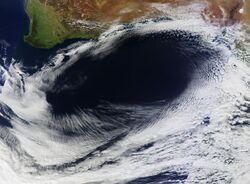
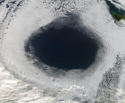
 The high featuring an anticlockwise rotation around an oval area of clear skies. | |
| Area of occurrence |
|
| Season | All-year round |
| Effect |
|
The Australian High, also known as the Australian subtropical ridge,[1] is a large, semi-permanent high pressure area or subtropical anticyclone that seasonally vacillates between the Great Australian Bight in the south to the Northern Territory in the north.[2] It is generally located between 25 and 40 degrees of south latitude, depending on the season.[3][4]
In summer, it typically sits over southern Australia as an Australian Bight High,[5] where it generally provides dry weather in the proximate region. In winter it normally moves north, therefore permitting cold fronts and low pressure systems to relocate up from the Great Australian Bight and bring rainfall to most parts of southern Australia.[6] The high is part of the subtropical ridge system and it is the reason why a large part of Australia is arid to semi-arid.[7]
Description

The Australian High tends to follow the seasonal variation in position of the sun; it is strongest and most persistent during the southern hemisphere summer and weakest during winter when it shifts towards the interior of Australia, as the westerly frontal systems becomes more active in the region around the Bight, thereby allowing cold fronts and low-pressure systems to perforate the southern states.[8]
This high-pressure block exhibits anticyclonic behaviour, circulating the air anticlockwise. It remains almost stationary for a prolonged period over the Bight, hence obstructing the typical easterly procession of weather systems across southern Australia.[9]
A cloud hole with an expansion as far as 1,000 kilometers (620 miles) has been observed, with tops of 1,040 millibars. The high may be extensive enough to interconnect with the Tasman High over in the Tasman Sea, just near New Zealand.[10][11]
Effects

The anticyclonic circulation produces a dry climate, bringing warm to hot weather in the southern Australian summer. The high influences the weather and climatic patterns of vast areas of Australia; The aridity of the Australian deserts and the summer drought of southern Australia is due to the large-scale subsidence and sinking motion of air in the system.[12]
In winter, when the high remains stationary in southern Australia (in a positive SAM phase), it can block or replace cold fronts from the Bight, thereby allowing warm weather to the southeast.[13] However, when the high remains fixed south of Western Australia, it can drive in polar air towards the continent, whereby increasing snowfall and rain in the southeast, particularly areas that lie west of the Great Dividing Range (due to the foehn effect).[14] Conversely, a large high stationed below South Australia can bring persistent rainfall to the east coast of Australia, whilst proving clear conditions to Tasmania.[15]
In the western part of the high, hot dry northerly winds from the dry centre push through South Australia and Victoria, ensuing heatwave conditions in these regions. The Australian High is one the drivers of the Southerly buster, which occurs in the southeast coast in the summer.[16] In winter, when the high pressure system is broad over the Australian landmass, widespread frost may occur.[17]
Effects on Asia
During the southern winter, the Australian High is one of the driving forces behind the South Asian Monsoon. Easterly winds blow from the center of the high towards Asia, and are deflected in a southwest direction towards India after crossing the equator due to the Coriolis effect.
Tasman High
Between summer and autumn, the high over southern Australia may be linked, or would intertwine, with the Tasman High in the southern Tasman Sea. When the high stalls in the Tasman Sea and becomes a blocking high, New Zealand and Tasmania will generally experience warm and generally dry weather, whilst the east coast of Australia (particularly southern Queensland and New South Wales) will experience moist onshore flows, particularly during a La Niña phase.[18] In March 2021, and also in February and March 2022, a stubborn blocking high in the south Tasman Sea caused heavy rain and flooding over large parts of Southeast Queensland and coastal New South Wales.[8][19][20]
See also
- Climate of Australia
- Brickfielder
References
- ↑ An assessment of relationships between the Australian subtropical ridge, rainfall variability and high-latitude circulation patterns by Dr Allyson A.J. Williams and Dr Roger C. Stone. Queensland Climate Change Centre of Excellence, Nambour, Queensland.
- ↑ An Australian "Anti-storm" EOS Project Science Office at NASA Goddard Space Flight Center. 5 June 2012.
- ↑ Summary of Weather Terms Bushwalking Leadership. Retrieved 7 April 2022.
- ↑ The Sub-tropical Ridge Bureau of Meteorology. Retrieved May 31, 2023
- ↑ Australian Bight High slows down GSC front runners and could reshuffle rankings by Marco Nannini from Global Solo Challenge. Retrieved 12 July 2024.
- ↑ Sub-tropical Ridge Example. Bureau of Meteorology. 2 April, 2008. Retrieved 31 May, 2023.
- ↑ Subtropical ridge leaves us high and dry this June Bureau of Meteorology. July 2017. Retrieved 31 May, 2023.
- ↑ 8.0 8.1 STALLED WEATHER: HOW STUCK AIR PRESSURE SYSTEMS DRIVE FLOODS AND HEATWAVES by Steve Turton from PreventionWeb.net. 3 March 2022
- ↑ Southern Annular Mode: The climate 'influencer' you may not have heard of By Kate Doyle from ABC. 14 August 2018. Retrieved 7 April 2022.
- ↑ High pressure systems: everything you need to know by Ben Domensino from Weatherzone. 21 May 2018. Retrieved 22 April 2022.
- ↑ THE CLIMATE KELPIE BLOG: Where have our winters gone? by Climate Kelpie. 6 May 2020.
- ↑ Extreme heat on its way to northwest WA by Ben Domensino from Weatherzone. 12 February 2022. Retrieved 7 April 2022.
- ↑ Sydney's record 15-day spell of 20 degree winter days by Ben Domensino from Weatherzone. 23 August 2021
- ↑ Australian snow, rain and heat linked by blocked weather systems, climatologist says By Ben Deacon from ABC Weather. 9 June 2022.
- ↑ Unrelenting high pressure dominating Australia’s weather by Ben Domensino from Weatherzone. 7 May 2024. Retrieved 9 May 2024.
- ↑ Modelling coastally trapped wind surges over Southeastern Australia. Reid, Helen J. 1999. UNSW
- ↑ Frost expected across nearly every state and territory in Australia this weekend By Tyne Logan from ABC News. 27 May 2023.
- ↑ Special Climate Statement—record warmth in the Tasman Sea, New Zealand and Tasmania Bureau of Meteorology. 27 March 2018
- ↑ THE CLIMATE AND WEATHER OF NELSON AND TASMAN 2nd edition G. R. Macara
- ↑ Weather: Blocking high expected to keep much of country warm, mostly dry for last days of summer by Michael Daly from Stuff. February 23 2021.
External links
- An assessment of relationships between the Australian subtropical ridge, rainfall variability and high-latitude circulation patterns.
- Influence of Global-Scale Variability on the Subtropical Ridge over Southeast Australia
 |
 KSF
KSF
