BP Structure
Topic: Earth
 From HandWiki - Reading time: 4 min
Short description: Exposed impact crater in Libya
| Gebel Dalma | |
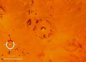
 Landsat image of the BP structure; screen capture from NASA World Wind | |
| Impact crater/structure | |
|---|---|
| Confidence | Confirmed |
| Diameter | 2 kilometres (1.2 mi) |
| Age | <120 Ma |
| Exposed | Yes |
| Drilled | No |
| Location | |
| Country | Libya |
| Lua error in Module:Location_map at line 422: No value was provided for longitude. | |

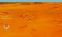
The BP Structure, also known as Gebel Dalma, is an exposed impact crater in Libya. It is so called because it was identified by a BP (then British Petroleum) geological survey team.[1]
French et al. state that the BP Structure and the larger Oasis crater, about 88 km (55 mi) to the south, were probably simultaneous impacts.[2] Both impacts deform the Nubian Sandstone of early Cretaceous age.
See also
References
- ↑ "BP". Earth Impact Database. Planetary and Space Science Centre University of New Brunswick Fredericton. http://www.passc.net/EarthImpactDatabase/New%20website_05-2018/bpstructure.html. Retrieved 2009-08-12.
- ↑ BEVAN M. FRENCH, JAMES R. UNDERWOOD, EDWARD P. FISK; Shock-Metamorphic Features in Two Meteorite Impact Structures, Southeastern Libya. GSA Bulletin 1974;; 85 (9): 1425–1428. doi: https://doi.org/10.1130/0016-7606(1974)85<1425:SFITMI>2.0.CO;2
External links
- Anonymous (nd) Africa (Impact Craters), Earth Impact Database, Planetary and Space Science Centre, University of New Brunswick, New Brunswick, Canada.
[ ⚑ ] 25°19′10″N 24°18′34″E / 25.31944°N 24.30944°E
 |
Licensed under CC BY-SA 3.0 | Source: https://handwiki.org/wiki/Earth:BP_Structure53 views | Status: cached on January 25 2026 09:56:40↧ Download this article as ZWI file
 KSF
KSF

