Beringia
Topic: Earth
 From HandWiki - Reading time: 15 min
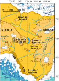
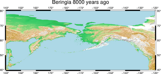
Beringia is defined today as the land and maritime area bounded on the west by the Lena River in Russia ; on the east by the Mackenzie River in Canada ; on the north by 72 degrees north latitude in the Chukchi Sea; and on the south by the tip of the Kamchatka Peninsula.[1] It includes the Chukchi Sea, the Bering Sea, the Bering Strait, the Chukchi and Kamchatka Peninsulas in Russia as well as Alaska in the United States and the Yukon in Canada .
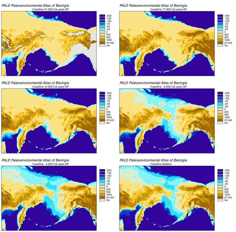
The area includes land lying on the North American Plate and Siberian land east of the Chersky Range. At various times, it formed a land bridge referred to as the Bering land bridge, that was up to 1,000 kilometres (620 miles) wide at its greatest extent and which covered an area as large as British Columbia and Alberta together,[2] totaling approximately 1,600,000 square kilometres (620,000 square miles), allowing biological dispersal to occur between Asia and North America. Today, the only land that is visible from the central part of the Bering land bridge are the Diomede Islands, the Pribilof Islands of St. Paul and St. George, St. Lawrence Island, St. Matthew Island, and King Island.[1]
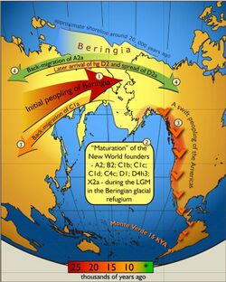
It is believed that a small human population of at most a few thousand arrived in Beringia from eastern Siberia during the Last Glacial Maximum before expanding into the settlement of the Americas sometime after 16,500 years Before Present (YBP).[3] This would have occurred as the American glaciers blocking the way southward melted,[4][5][6][7][8] but before the bridge was covered by the sea about 11,000 YBP.[9][10]
Etymology
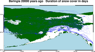
The term Beringia was coined by the Swedish botanist Eric Hultén in 1937, from the Danish explorer Vitus Bering.[11] During the ice ages, Beringia, like most of Siberia and all of North and Northeast China, was not glaciated because snowfall was very light.[12]
Geography
The remains of Late Pleistocene mammals that had been discovered on the Aleutians and islands in the Bering Sea at the close of the nineteenth century indicated that a past land connection might lie beneath the shallow waters between Alaska and Chukotka. The underlying mechanism was first thought to be tectonics, but by 1930 changes in the ice mass balance, leading to global sea-level fluctuations were viewed as the cause of the Bering land bridge.[13][14] In 1937, Eric Hultén proposed that around the Aleutians and the Bering Strait region were tundra plants that had originally dispersed from a now-submerged plain between Alaska and Chukotka, which he named Beringia after the Dane Vitus Bering who had sailed into the strait in 1728.[15][14] The American arctic geologist David Hopkins redefined Beringia to include portions of Alaska and Northeast Asia. Beringia was later regarded as extending from the Verkhoyansk Mountains in the west to the Mackenzie River in the east.[14] The distribution of plants in the genera Erythranthe and Pinus are good examples of this, as very similar genera members are found in Asia and the Americas.[16][17]
During the Pleistocene epoch, global cooling led periodically to the expansion of glaciers and the lowering of sea levels. This created land connections in various regions around the globe.[18] Today, the average water depth of the Bering Strait is 40–50 m (130–160 ft); therefore the land bridge opened when the sea level dropped more than 50 m (160 ft) below the current level.[19][20] A reconstruction of the sea-level history of the region indicated that a seaway existed from c. 135,000 – c. 70,000 YBP, a land bridge from c. 70,000 – c. 60,000 YBP, an intermittent connection from c. 60,000 – c. 30,000 YBP, a land bridge from c. 30,000 – c. 11,000 YBP, followed by a Holocene sea-level rise that reopened the strait.[21][22] Post-glacial rebound has continued to raise some sections of the coast.
During the last glacial period, enough of the earth's water became frozen in the great ice sheets covering North America and Europe to cause a drop in sea levels. For thousands of years the sea floors of many interglacial shallow seas were exposed, including those of the Bering Strait, the Chukchi Sea to the north, and the Bering Sea to the south. Other land bridges around the world have emerged and disappeared in the same way. Around 14,000 years ago, mainland Australia was linked to both New Guinea and Tasmania, the British Isles became an extension of continental Europe via the dry beds of the English Channel and North Sea, and the dry bed of the South China Sea linked Sumatra, Java, and Borneo to Indochina.
Refugium
The last glacial period, commonly referred to as the "Ice Age", spanned 125,000[23]–14,500 YBP[24] and was the most recent glacial period within the current ice age, which occurred during the last years of the Pleistocene era.[23] The Ice Age reached its peak during the Last Glacial Maximum, when ice sheets began advancing from 33,000 YBP and reached their maximum limits 26,500 YBP. Deglaciation commenced in the Northern Hemisphere approximately 19,000 YBP and in Antarctica approximately 14,500 years YBP, which is consistent with evidence that glacial meltwater was the primary source for an abrupt rise in sea level 14,500 YBP[24] and the bridge was finally inundated around 11,000 YBP.[10] The fossil evidence from many continents points to the extinction of large animals, termed Pleistocene megafauna, near the end of the last glaciation.[25]
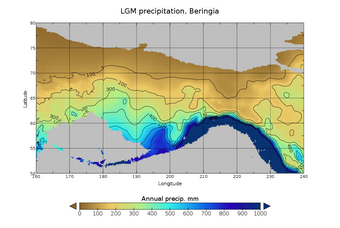
During the Ice Age a vast, cold and dry Mammoth steppe stretched from the arctic islands southwards to China, and from Spain eastwards across Eurasia and over the Bering land bridge into Alaska and the Yukon where it was blocked by the Wisconsin glaciation. Therefore, the flora and fauna of Beringia were more related to those of Eurasia rather than North America. Beringia received more moisture and intermittent maritime cloud cover from the north Pacific Ocean than the rest of the Mammoth steppe, including the dry environments on either side of it. This moisture supported a shrub-tundra habitat that provided an ecological refugium for plants and animals.[26][27] In East Beringia 35,000 YBP, the northern arctic areas experienced temperatures 1.5 °C (2.7 °F) degrees warmer than today but the southern sub-Arctic regions were 2 °C (4 °F) degrees cooler. During the LGM 22,000 YBP the average summer temperature was 3–5 °C (5–9 °F) degrees cooler than today, with variations of 2.9 °C (5.2 °F) degrees cooler on the Seward Peninsula to 7.5 °C (13.5 °F) cooler in the Yukon.[28] In the driest and coldest periods of the Late Pleistocene, and possibly during the entire Pleistocene, moisture occurred along a north–south gradient with the south receiving the most cloud cover and moisture due to the air-flow from the North Pacific.[27]
In the Late Pleistocene, Beringia was a mosaic of biological communities.[29][26][30] Commencing from c. 57,000 YBP (MIS 3), steppe–tundra vegetation dominated large parts of Beringia with a rich diversity of grasses and herbs.[29][26][31] There were patches of shrub tundra with isolated refugia of larch (Larix) and spruce (Picea) forests with birch (Betula) and alder (Alnus) trees.[29][30][31][32] It has been proposed that the largest and most diverse megafaunal community residing in Beringia at this time could only have been sustained in a highly diverse and productive environment.[33]
Analysis at Chukotka on the Siberian edge of the land bridge indicated that from c. 57,000 – c. 15,000 YBP (MIS 3 to MIS 2) the environment was wetter and colder than the steppe–tundra to the east and west, with warming in parts of Beringia from c. 15,000 YBP.[34] These changes provided the most likely explanation for mammal migrations after c. 15,000 YBP, as the warming provided increased forage for browsers and mixed feeders.[35] At the beginning of the Holocene, some mesic habitat-adapted species left the refugium and spread westward into what had become tundra-vegetated northern Asia and eastward into northern North America.[27]
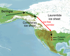
The latest emergence of the land bridge was c. 70,000 years ago. However, from c. 24,000 – c. 13,000 YBP the Laurentide Ice Sheet fused with the Cordilleran Ice Sheet, which blocked gene flow between Beringia (and Eurasia) and continental North America.[36][37][38] The Yukon corridor opened between the receding ice sheets c. 13,000 YBP, and this once again allowed gene flow between Eurasia and continental North America until the land bridge was finally closed by rising sea levels c. 10,000 YBP.[39] During the Holocene, many mesic-adapted species left the refugium and spread eastward and westward, while at the same time the forest-adapted species spread with the forests up from the south. The arid-adapted species were reduced to minor habitats or became extinct.[27]
Beringia constantly transformed its ecosystem as the changing climate affected the environment, determining which plants and animals were able to survive. The land mass could be a barrier as well as a bridge: during colder periods, glaciers advanced and precipitation levels dropped. During warmer intervals, clouds, rain and snow altered soils and drainage patterns. Fossil remains show that spruce, birch and poplar once grew beyond their northernmost range today, indicating that there were periods when the climate was warmer and wetter. The environmental conditions were not homogenous in Beringia. Recent stable isotope studies of woolly mammoth bone collagen demonstrate that western Beringia (Siberia) was colder and drier than eastern Beringia (Alaska and Yukon), which was more ecologically diverse.[40]
Grey wolves suffered a species-wide population bottleneck (reduction) approximately 25,000 YBP during the Last Glacial Maximum. This was followed by a single population of modern wolves expanding out of their Beringia refuge to repopulate the wolf's former range, replacing the remaining Late Pleistocene wolf populations across Eurasia and North America.[41][42][43]
The extinct pine species Pinus matthewsii has been described from Pliocene sediments in the Yukon areas of the refugium.[44]
Beringian Gap
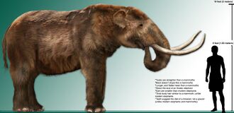
The existence of fauna endemic to the respective Siberian and North American portions of Beringia has led to the 'Beringian Gap' hypothesis, wherein an unconfirmed geographic factor blocked migration across the land bridge when it emerged. Beringia did not block the movement of most dry steppe-adapted large species such as saiga antelope, woolly mammoth, and caballid horses.[27] Notable restricted fauna include cave hyenas, and the woolly rhino in Siberia (which went no further east than the Anadyr River), and Arctodus simus, American badger, American kiang-like equids, Bootherium and Camelops in North America, with the existence of Homotherium being disputed in Late Pleistocene Siberia. The lack of mastodon and Megalonyx has been attributed to their inhabitation of Alaska and the Yukon being limited to interglacials.[45][46][47] However, ground sloth eDNA has potentially been recovered from Siberia.[48]
Human habitation and migration
Around 3,000 years ago, the progenitors of the Yupik peoples settled along both sides of the straits.[49] The governments of Russia and the United States announced a plan to formally establish "a transboundary area of shared Beringian heritage". Among other things this agreement would establish close ties between the Bering Land Bridge National Preserve and the Cape Krusenstern National Monument in the United States and Beringia National Park in Russia.[50]
Previous connections
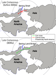
Biogeographical evidence demonstrates previous connections between North America and Asia.[51] Similar dinosaur fossils occur both in Asia and in North America.[52] The dinosaur Saurolophus was found in both Mongolia and western North America.[53] Relatives of Troodon, Triceratops, and Tyrannosaurus rex all came from Asia.[54][55]
The earliest Canis lupus specimen was a fossil tooth discovered at Old Crow, Yukon, Canada. The specimen was found in sediment dated 1 million YBP,[56] however the geological attribution of this sediment is questioned.[56][57] Slightly younger specimens were discovered at Cripple Creek Sump, Fairbanks, Alaska, in strata dated 810,000 YBP. Both discoveries point to the origin of these wolves in eastern Beringia during the Middle Pleistocene.[56]
Fossil evidence also indicates an exchange of primates and plants between North America and Asia around 55.8 million years ago.[51][58][59] 20 million years ago, evidence in North America shows the last natural interchange of mammalian species. Some, like the ancient saber-toothed cats, have a recurring geographical range: Europe, Africa, Asia, and North America.[51]
See also
- Bering Strait crossing
- Bluefish Caves
- Little John (archeological site)
- Geologic time scale
- Last glacial period
- Paleoshoreline
- Pleistocene
- Yukon Beringia Interpretive Centre
References
- ↑ Dr Barbara Winter (2005). "A Journey to a New Land". virtualmuseum.ca. http://www.sfu.museum/journey/an-en/postsecondaire-postsecondary/pont_beringie-beringia_bridge.
- ↑ "BBC Earth | Home". https://www.bbcearth.com/.
- ↑ Wang, Sijia et al. (2007). "Genetic Variation and Population Structure in Native Americans". PLOS Genetics 3 (11): e185. doi:10.1371/journal.pgen.0030185. PMID 18039031.
- ↑ Goebel, Ted; Waters, Michael R.; O'Rourke, Dennis H. (2008). "The Late Pleistocene Dispersal of Modern Humans in the Americas". Science 319 (5869): 1497–1502. doi:10.1126/science.1153569. PMID 18339930. Bibcode: 2008Sci...319.1497G.
- ↑ Fagundes, Nelson J. R. (2008). "Mitochondrial Population Genomics Supports a Single Pre-Clovis Origin with a Coastal Route for the Peopling of the Americas". American Journal of Human Genetics 82 (3): 583–92. doi:10.1016/j.ajhg.2007.11.013. PMID 18313026.
- ↑ Tamm, Erika (2007). Carter, Dee. ed. "Beringian Standstill and Spread of Native American Founders". PLoS ONE 2 (9): e829. doi:10.1371/journal.pone.0000829. PMID 17786201. Bibcode: 2007PLoSO...2..829T.
- ↑ Achilli, A. (2008). MacAulay, Vincent. ed. "The Phylogeny of the Four Pan-American MtDNA Haplogroups: Implications for Evolutionary and Disease Studies". PLOS ONE 3 (3): e1764. doi:10.1371/journal.pone.0001764. PMID 18335039. Bibcode: 2008PLoSO...3.1764A.
- ↑ Elias, Scott A.; Short, Susan K.; Nelson, C. Hans; Birks, Hilary H. (1996). "Life and times of the Bering land bridge". Nature 382 (6586): 60. doi:10.1038/382060a0. Bibcode: 1996Natur.382...60E.
- ↑ 10.0 10.1 Jakobsson, Martin; Pearce, Christof; Cronin, Thomas M.; Backman, Jan; Anderson, Leif G.; Barrientos, Natalia; Björk, Göran; Coxall, Helen et al. (2017). "Post-glacial flooding of the Beringia Land Bridge dated to 11,000 cal yrs YBP based on new geophysical and sediment records". Climate of the Past Discussions: 1–22. doi:10.5194/cp-2017-11.
- ↑ John F. Hoffecker; Scott A. Elias (2007). Human Ecology of Beringia. Columbia University Press. p. 3. ISBN 978-0-231-13060-8. https://books.google.com/books?id=VgomQY3o9U0C&pg=PA3. Retrieved 2016-04-10.
- ↑ Karel Hendrik Voous (1973). Proceedings of the 15th International Ornithological Congress, The Hague, The Netherlands 30 August–5 September 1970. Brill Archive. p. 33. ISBN 978-90-04-03551-5. https://books.google.com/books?id=EdgUAAAAIAAJ&pg=PA33. Retrieved 2016-04-10.
- ↑ Hopkins DM. 1967. Introduction. In: Hopkins DM, editor. The Bering land bridge. Stanford: Stanford University Press. pp. 1–6.
- ↑ 14.0 14.1 14.2 Hoffecker, John F.; Elias, Scott A.; O'Rourke, Dennis H.; Scott, G. Richard; Bigelow, Nancy H. (2016). "Beringia and the global dispersal of modern humans". Evolutionary Anthropology: Issues, News, and Reviews 25 (2): 64–78. doi:10.1002/evan.21478. PMID 27061035.
- ↑ Hultén E. 1937. Outline of the history of arctic and boreal biota during the Quaternary Period. New York: Lehre J. Cramer.
- ↑ Nesom, G. L. (2011). "A New Species of Erythranthe (Phrymaceae) From China". Phytoneuron 7: 1–5. ISSN 2153-733X. http://www.phytoneuron.net/2017Phytoneuron/07PhytoN-Erythranthediminuens.pdf.
- ↑ Brubaker, Linda B.; Anderson, Patricia; Edwards, Mary E.; Anatoly, Lozhkin (2005). "Beringia as a glacial refugium for boreal trees and shrubs: New perspectives from mapped pollen data". Journal of Biogeography 32 (5): 833–48. doi:10.1111/j.1365-2699.2004.01203.x. https://www.researchgate.net/publication/229646915.
- ↑ [Lowe JJ, Walker M. 1997 Reconstructing quaternary environments, 2nd edn. Harlow, UK: Prentice Hall.
- ↑ Miller, K.G.; Kominz, M.A.; Browning, J.V.; Wright, J.D.; Mountain, G.S.; Katz, M.E.; Sugarman, P.J.; Cramer, B.S. et al. (2005). "The Phanerozoic record of global sea-level change". Science 310 (5752): 1293–98. doi:10.1126/science.1116412. PMID 16311326. Bibcode: 2005Sci...310.1293M. https://academiccommons.columbia.edu/doi/10.7916/D8C53WV8/download.
- ↑ Siddall, M.; Rohling, E.J.; Almogi-Labin, A.; Hemleben, C.; Eischner, D.; Schmelzer, I; Smeed, D.A. (2003). "Sealevel fluctuations during the last glacial cycle". Nature 423 (6942): 853–58. doi:10.1038/nature01690. PMID 12815427. Bibcode: 2003Natur.423..853S.
- ↑ Hu, Aixue; Meehl, Gerald A.; Otto-Bliesner, Bette L.; Waelbroeck, Claire; Han, Weiqing; Loutre, Marie-France; Lambeck, Kurt; Mitrovica, Jerry X. et al. (2010). "Influence of Bering Strait flow and North Atlantic circulation on glacial sea-level changes". Nature Geoscience 3 (2): 118. doi:10.1038/ngeo729. Bibcode: 2010NatGe...3..118H.
- ↑ Meiri, M.; Lister, A. M.; Collins, M. J.; Tuross, N.; Goebel, T.; Blockley, S.; Zazula, G. D.; Van Doorn, N. et al. (2013). "Faunal record identifies Bering isthmus conditions as constraint to end-Pleistocene migration to the New World". Proceedings of the Royal Society B: Biological Sciences 281 (1776): 20132167. doi:10.1098/rspb.2013.2167. PMID 24335981.
- ↑ 23.0 23.1 Intergovernmental Panel on Climate Change (UN) (2007). "IPCC Fourth Assessment Report: Climate Change 2007 – Palaeoclimatic Perspective". The Nobel Foundation. https://www.ipcc.ch/publications_and_data/ar4/wg1/en/spmsspm-a-palaeoclimatic.html.
- ↑ 24.0 24.1 Clark, P. U.; Dyke, A. S.; Shakun, J. D.; Carlson, A. E.; Clark, J.; Wohlfarth, B.; Mitrovica, J. X.; Hostetler, S. W. et al. (2009). "The Last Glacial Maximum". Science 325 (5941): 710–14. doi:10.1126/science.1172873. PMID 19661421. Bibcode: 2009Sci...325..710C.
- ↑ Elias, S.A.; Schreve, D. (2016). "Late Pleistocene Megafaunal Extinctions". Encyclopedia of Quaternary Science (in Reference Module in Earth Systems and Environmental Sciences, pp. 3202–17). pp. 700–712. doi:10.1016/B978-0-12-409548-9.10283-0. ISBN 978-0-12-409548-9. https://pure.royalholloway.ac.uk/portal/files/1398773/Article_318_Late_Pleistocene_megafaunal_extinctions.pdf. Retrieved 2017-05-04.
- ↑ 26.0 26.1 26.2 Elias SA, Crocker B. 2008 The Bering land bridge: a moisture barrier to the dispersal of steppe-tundra biota? Q. Sci. Rev. 27, 2473–83
- ↑ 27.0 27.1 27.2 27.3 27.4 Guthrie RD. 2001 Origin and causes of the mammoth steppe: a story of cloud cover, woolly mammal tooth pits, buckles, and inside-out Beringia. Q. Sci. Rev. 20, 549–74.
- ↑ Elias, S.A.; Brigham-Grette, J. (2007). "GLACIATIONS Late Pleistocene Events in Beringia". Encyclopedia of Quaternary Science. p. 1057. doi:10.1016/B0-44-452747-8/00132-0. ISBN 9780444527479. https://pure.royalholloway.ac.uk/portal/files/1398755/Article_105_Late_Pleistocene_events_in_Beringia.pdf. Retrieved 2 May 2017.
- ↑ 29.0 29.1 29.2 Hoffecker JF, Elias SA. 2007 Human ecology of Beringia. New York, NY: Columbia University Press.
- ↑ 30.0 30.1 Brigham-Grette J, Lozhkin AV, Anderson PM, Glushkova OY. 2004 Paleoenvironmental conditions in Western Beringia before and during the Last Glacial Maximum. In Entering America, Northeast Asia and Beringia Before the Last Glacial Maximum (ed. Madsen DB), pp. 29–61. Salt Lake City, UT: University of Utah Press
- ↑ 31.0 31.1 Sher AV, Kuzmina SA, Kuznetsova TV, Sulerzhitsky LD. 2005 New insights into the Weichselian environment and climate of the East Siberian Arctic, derived from fossil insects, plants, and mammals. Q. Sci. Rev. 24, 533–69.
- ↑ Anderson PH, Lozhkin AV. 2001 The Stage 3 interstadial complex (Karginskii/middle Wisconsinan interval) of Beringia: variations in paleoenvironments and implications for paleoclimatic interpretations. Q. Sci. Rev. 20, 93–125
- ↑ Guthrie RD. 1982 Mammals of the mammoth steppe as paleoenvironmental indicators. In Paleoecology of Beringia (eds Hopkins DM, Matthews JV, Schweger CE, Young SB), pp. 307–24. New York: Academic Press
- ↑ Kuzmina SA, Sher AV, Edwards ME, Haile J, Yan EV, Kotov AV, Willerslev E. 2011 The late Pleistocene environment of the Eastern West Beringia based on the principal section at the Main River, Chukotka. Q. Sci. Rev. 30, 2091–2106
- ↑ Meiri, M.; Lister, A. M.; Collins, M. J.; Tuross, N.; Goebel, T.; Blockley, S.; Zazula, G. D.; Van Doorn, N. et al. (2013). "Faunal record identifies Bering isthmus conditions as constraint to end-Pleistocene migration to the New World". Proceedings of the Royal Society B: Biological Sciences 281 (1776): 20132167. doi:10.1098/rspb.2013.2167. PMID 24335981.
- ↑ Burns, J.A. (2010). "Mammalian faunal dynamics in Late Pleistocene, Alberta, Canada". Quaternary International 217 (1–2): 37–42. doi:10.1016/j.quaint.2009.08.003. Bibcode: 2010QuInt.217...37B.
- ↑ Gowan, E.J. (2013) An assessment of the minimum timing of ice free conditions of the western Laurentide Ice Sheet. Quaternary Science Review, 75, 100–13.
- ↑ Rabassa, J.; Ponce, J.F. (2013). "The Heinrich and Dansgaard-Oeschger climatic events during Marine Isotopic Stage 3:searching for appropriate times for human colonization of the America". Quaternary International 299: 94–105. doi:10.1016/j.quaint.2013.04.023. Bibcode: 2013QuInt.299...94R.
- ↑ Koblmüller, Stephan; Vilà, Carles; Lorente-Galdos, Belen; Dabad, Marc; Ramirez, Oscar; Marques-Bonet, Tomas; Wayne, Robert K.; Leonard, Jennifer A. (2016). "Whole mitochondrial genomes illuminate ancient intercontinental dispersals of grey wolves (Canis lupus)". Journal of Biogeography 43 (9): 1728. doi:10.1111/jbi.12765.
- ↑ Szpak, Paul (2010). "Regional differences in bone collagen δ13C and δ15N of Pleistocene mammoths: Implications for paleoecology of the mammoth steppe". Palaeogeography, Palaeoclimatology, Palaeoecology 286 (1–2): 88–96. doi:10.1016/j.palaeo.2009.12.009. Bibcode: 2010PPP...286...88S. https://uwo.academia.edu/PaulSzpak/Papers/156300/Regional_differences_in_bone_collagen_13C_and_15N_of_Pleistocene_mammoths_Implications_for_paleoecology_of_the_mammoth_steppe.
- ↑ Loog, Liisa; Thalmann, Olaf; Sinding, Mikkel-Holger S.; Schuenemann, Verena J.; Perri, Angela; Germonpré, Mietje; Bocherens, Herve; Witt, Kelsey E. et al. (2019). "Ancient DNA suggests modern wolves trace their origin to a late Pleistocene expansion from Beringia". Molecular Ecology 29 (9): 1596–1610. doi:10.1111/mec.15329. PMID 31840921.
- ↑ Werhahn, Geraldine; Senn, Helen; Ghazali, Muhammad; Karmacharya, Dibesh; Sherchan, Adarsh Man; Joshi, Jyoti; Kusi, Naresh; López-Bao, José Vincente et al. (2018). "The unique genetic adaptation of the Himalayan wolf to high-altitudes and consequences for conservation". Global Ecology and Conservation 16: e00455. doi:10.1016/j.gecco.2018.e00455.
- ↑ Schweizer, Rena M.; Wayne, Robert K. (2020). "Illuminating the mysteries of wolf history". Molecular Ecology 29 (9): 1589–91. doi:10.1111/MEC.15438. PMID 32286714.
- ↑ McKown, A.D.; Stockey, R.A.; Schweger, C.E. (2002). "A New Species of Pinus Subgenus Pinus Subsection Contortae From Pliocene Sediments of Ch'Ijee's Bluff, Yukon Territory, Canada". International Journal of Plant Sciences 163 (4): 687–697. doi:10.1086/340425. https://www.academia.edu/404576.
- ↑ Stuart, Anthony J.; Lister, Adrian M. (2012-09-19). "Extinction chronology of the woolly rhinoceros Coelodonta antiquitatis in the context of late Quaternary megafaunal extinctions in northern Eurasia". Quaternary Science Reviews 51: 1–17. doi:10.1016/j.quascirev.2012.06.007. ISSN 0277-3791. https://www.sciencedirect.com/science/article/pii/S0277379112002326.
- ↑ "Beringia: Lost World of the Ice Age (U.S. National Park Service)" (in en). https://www.nps.gov/articles/aps-v12-i2-c8.htm.
- ↑ Blinnikov, Mikhail S.; Gaglioti, Benjamin V.; Walker, Donald A.; Wooller, Matthew J.; Zazula, Grant D. (2011-10-01). "Pleistocene graminoid-dominated ecosystems in the Arctic" (in en). Quaternary Science Reviews 30 (21): 2906–2929. doi:10.1016/j.quascirev.2011.07.002. ISSN 0277-3791. Bibcode: 2011QSRv...30.2906B. https://www.sciencedirect.com/science/article/pii/S027737911100206X.
- ↑ Courtin, Jérémy; Perfumo, Amedea; Andreev, Andrei A.; Opel, Thomas; Stoof‐Leichsenring, Kathleen R.; Edwards, Mary E.; Murton, Julian B.; Herzschuh, Ulrike (July 2022). "Pleistocene glacial and interglacial ecosystems inferred from ancient DNA analyses of permafrost sediments from Batagay megaslump, East Siberia" (in en). Environmental DNA 4 (6): 1265–1283. doi:10.1002/edn3.336. ISSN 2637-4943. https://onlinelibrary.wiley.com/doi/10.1002/edn3.336.
- ↑ "A Study of the Yupik People". http://www.kibin.com/essay-examples/a-study-of-the-yupik-people-AkpEcW1B.
- ↑ Llanos, Miguel (21 September 2012). "Ancient land of 'Beringia' gets protection from US, Russia". NBC News. http://worldnews.nbcnews.com/_news/2012/09/21/13941998-ancient-land-of-beringia-gets-protection-from-us-russia?lite.
- ↑ 51.0 51.1 51.2 51.3 "Fig. 1. Biogeographic connections of the Beringian region through time...". https://www.researchgate.net/figure/Biogeographic-connections-of-the-Beringian-region-through-time-adapted-from-Sanmart-in_fig1_306339486.
- ↑ Hunt, Katie (May 6, 2020). "Arctic dinosaur may have crossed between Asia and America to dominate the north". https://www.cnn.com/2020/05/06/world/arctic-dinosaur-edmontosaurus-scn/index.html.
- ↑ Norell, M. 2019. SAUROLOPHUS OSBORNI. The World of Dinosaurs: An Illustrated Tour. Chicago: University of Chicago Press, pp. 218-219.
- ↑ Fiorillo, Anthony R. (2014-05-05). "Dinosaurs of Arctic Alaska". Scientific American (Springer Science and Business Media LLC) 23 (2s): 54–61. doi:10.1038/scientificamericandinosaurs0514-54. ISSN 1936-1513.
- ↑ Fiorillo, Anthony R. (2004). "The Dinosaurs of Arctic Alaska". Scientific American (Scientific American, a division of Nature America, Inc.) 291 (6): 84–91. doi:10.1038/scientificamerican1204-84. ISSN 0036-8733. PMID 15597984. Bibcode: 2004SciAm.291f..84F. http://www.jstor.org/stable/26060803. Retrieved 2023-02-21.
- ↑ 56.0 56.1 56.2 Tedford, Richard H.; Wang, Xiaoming; Taylor, Beryl E. (2009). "Phylogenetic Systematics of the North American Fossil Caninae (Carnivora: Canidae)". Bulletin of the American Museum of Natural History 325: 1–218. doi:10.1206/574.1. http://digitallibrary.amnh.org/dspace/bitstream/2246/5999/1/B325.pdf.
- ↑ Westgate, John A; Pearce, G. William; Preece, Shari J; Schweger, Charles E; Morlan, Richard E; Pearce, Nicholas J.G; Perkins, T. William (2017). "Tephrochronology, magnetostratigraphy and mammalian faunas of Middle and Early Pleistocene sediments at two sites on the Old Crow River, northern Yukon Territory, Canada". Quaternary Research 79: 75–85. doi:10.1016/j.yqres.2012.09.003.
- ↑ Marris, Emma (March 3, 2008). "How primates crossed continents". Nature. doi:10.1038/news.2008.637. https://www.nature.com/articles/news.2008.637.
- ↑ Jiang, Dechun; Klaus, Sebastian; Zhang, Ya-Ping; Hillis, David M; Li, Jia-Tang (15 March 2019). "Asymmetric biotic interchange across the Bering land bridge between Eurasia and North America". National Science Review 6 (4): 739–745. doi:10.1093/nsr/nwz035. ISSN 2095-5138. PMID 34691929.
Further reading
- Demuth, Bathsheba (2019) Floating Coast: An Environmental History of the Bering Strait. W. W. Norton & Company. ISBN:978-0-393-35832-2.
- Fagundes, Nelson J.R.; Kanitz, Ricardo; Eckert, Roberta; Valls, Ana C.S.; Bogo, Mauricio R.; Salzano, Francisco M.; Smith, David Glenn; Silva Jr., Wilson A. et al. (3 March 2008). "Mitochondrial Population Genomics Supports a Single Pre-Clovis Origin with a Coastal Route for the Peopling of the Americas". American Journal of Human Genetics 82 (3): 583–92. doi:10.1016/j.ajhg.2007.11.013. PMID 18313026.
- Hoffecker, John F.; Elias, Scott A. (2007). Human ecology of Beringia. Columbia University Press. ISBN 978-0-231-13060-8. https://books.google.com/books?id=VgomQY3o9U0C. Retrieved 2016-04-10.
- Hoffecker, JF; Elias, SA; O'Rourke, DH (2014). "Anthropology. Out of Beringia?". Science 343 (6174): 979–80. doi:10.1126/science.1250768. PMID 24578571. Bibcode: 2014Sci...343..979H.
- Hey, Jody (2005). "On the Number of New World Founders: A Population Genetic Portrait of the Peopling of the Americas". PLOS Biology 3 (6): e193. doi:10.1371/journal.pbio.0030193. PMID 15898833.
- Pielou, E. C., After the Ice Age: The Return of Life to Glaciated North America (Chicago: University of Chicago Press) 1992 ISBN:978-0-226-66812-3
- Pringle, Heather (2014). "Welcome to Beringia". Science 343 (6174): 961–63. doi:10.1126/science.343.6174.961. PMID 24578560. Bibcode: 2014Sci...343..961P.
External links
- CBC News: New map of Beringia 'opens your imagination' to what landscape looked like 18,000 years ago
- Shared Beringian Heritage Program
- International National Park in the Bering Strait
- Bering Land Bridge National Preserve
- D.K. Jordan, "Prehistoric Beringia"
- Paleoenvironmental atlas of Beringia: includes animation showing the gradual disappearance of the Bering land bridge
- Yukon Beringia Interpretive Centre
- Paleoenvironments and Glaciation in Beringia
- Study suggests 20000 year hiatus in Beringia
- The Fertile Shore
 |
 KSF
KSF