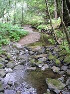
Gill (ravine)
Topic: Earth
 From HandWiki - Reading time: 5 min
A gill or ghyll is a ravine or narrow valley in the North of England and parts of Scotland. The word originates from the Old Norse gil.[1] Examples include Dufton Ghyll Wood, Dungeon Ghyll, Troller's Gill and Trow Ghyll. As a related usage, Gaping Gill is the name of a cave, not the associated stream, and Cowgill, Masongill and Halton Gill are derived names of villages.[2]
The stream flowing through a gill is often referred to as a beck: for example in Swaledale, Gunnerside Beck flows through Gunnerside Ghyll. Beck is also used as a more general term for streams in Yorkshire, Cumbria, south Durham and north Lanashire – examples include Ais Gill Beck, Arkle Beck and Peasey Beck. In the North Pennines, the word sike or syke[3] is found in similar circumstances. This is particularly common in the Appleby Fells area where sikes significantly outnumber the becks and gills; it can also be seen in the name of Eden Sike Cave in Mallerstang.
In the High Weald gills are deeply cut ravines, usually with a stream in the base[4] which eroded the ravine. These gills may be up to 200 feet (61 m) deep, which represents a significant physiographic feature in lowland England.[5]
See also
- List of generic forms in British place names
- Cumbrian placename etymology
References
- ↑ Anderson, G. K. (1938). "Two Ballads from Nineteenth Century Ohio". The Journal of American Folklore 51 (199): 38–46. doi:10.2307/535942. "I suggest-and it is only a tentative suggestion-that "g(u)ile" is "gill," spelled by Wordsworth "ghyll," a ravine or valley inclosing a small water-course."
- ↑ Daelnet placenames index , accessed 1 April 2012
- ↑ Ferguson, R.S. (1885). "The earthworks and keep, Appleby Castle". TCWAAS. http://archaeologydataservice.ac.uk/archiveDS/archiveDownload?t=arch-2055-1/dissemination/pdf/Article_Level_Pdf/tcwaas/001/1886/vol8/tcwaas_001_1886_vol8_0039.pdf.
- ↑ Natural England (2013). National Character Area profile:122: High Weald. Natural England. ISBN 978-1-78367-068-0. http://publications.naturalengland.org.uk/file/5851972632576000.
- ↑ Rose, F.; Patmore, J. M. (1997). Weald Gill Woodlands. English Nature, Sussex and Surrey Team, Lewes.
 |
 KSF
KSF
