Holy Island Group
Topic: Earth
 From HandWiki - Reading time: 2 min
| Holy Island Group Stratigraphic range: Furongian-Tremadoc ~497–477 Ma | |
|---|---|
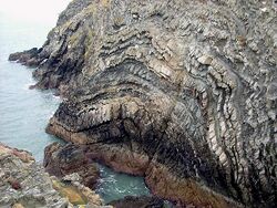
 Folded meta-sandstones and mudstones of the South Stack Formation, a subdivision of the Holy Island Group | |
| Type | Geological group |
| Unit of | Monian Supergroup |
| Sub-units | South Stack, Holyhead, Rhoscolyn and New Harbour formations |
| Underlies | Cemaes Group (unconformity) |
| Overlies | not exposed |
| Thickness | over 3,000 m (9,800 ft) |
| Lithology | |
| Primary | Metamorphosed sandstone |
| Other | Metamorphosed mudstone, quartzite, schist, phyllite etc |
| Location | |
| Coordinates | [ ⚑ ] : 53°18′N 4°40′W / 53.3°N 4.667°W |
| Region | Holy Island and Anglesey |
| Country | |
| Type section | |
| Named for | Holy Island, Anglesey |
| Lua error in Module:Location_map/multi at line 27: Unable to find the specified location map definition: "Module:Location map/data/Wales" does not exist. | |
The Holy Island Group is a sequence of metasedimentary rocks of Cambro-Ordovician (Furongian to Tremadocian) age found in northern and western Anglesey and the adjacent Holy Island in North Wales.[1] It comprises four formations; a lower South Stack Formation, an overlying Holyhead Formation, a succeeding Rhoscolyn Formation and an uppermost New Harbour Formation. The South Stack Formation outcrops on Holy Island, between Holyhead and South Stack and at Rhoscolyn, and also inland on Anglesey itself between Mynydd Mechell and Carreglefn.[2] The Holyhead and Rhoscolyn formations are restricted to the Holyhead Mountain and Rhoscolyn areas of Holy Island.[3] The New Harbour Formation, which previously enjoyed 'Group' status, is some 2km thick and conformably overlies the Rhoscolyn Formation. It extends across much of northern and western Anglesey and Holy Island.[4]
References
- ↑ "Holy Island Group". The BGS Lexicon of Named Rock Units. British Geological Survey. http://www.bgs.ac.uk/lexicon/lexicon.cfm?pub=NHI. Retrieved 3 November 2020.
- ↑ "South Stack Formation". British Geological Survey. https://webapps.bgs.ac.uk/lexicon/lexicon.cfm?pub=NSS. Retrieved 3 November 2020.
- ↑ "Holyhead Formation". British Geological Survey. https://webapps.bgs.ac.uk/lexicon/lexicon.cfm?pub=HHD. Retrieved 3 November 2020.
- ↑ "New Harbour Formation". British Geological Survey. https://webapps.bgs.ac.uk/lexicon/lexicon.cfm?pub=NNH. Retrieved 3 November 2020.
Further reading
Campbell,S., Wood,M. and Windley,B. (2014) Footsteps through Time: the rocks and landscape of Anglesey explained. GeoMôn, Isle of Anglesey County Council
 |
 KSF
KSF