Keyser Formation
Topic: Earth
 From HandWiki - Reading time: 4 min
| Keyser Formation Stratigraphic range: Pridoli-Lochkovian[1] | |
|---|---|
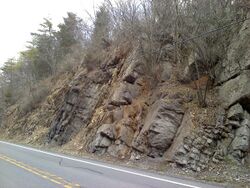
 Outcrop of the Keyser Formation on U.S. Route 522 in Fulton County, Pennsylvania, north of Warfordsburg | |
| Type | Sedimentary |
| Unit of | Helderberg Group |
| Sub-units | Byers Island, Jersey Shore & La Vale Members |
| Underlies | New Creek Limestone and Old Port Formation |
| Overlies | Tonoloway Formation |
| Thickness | 33 m (108 ft) at Allegheny Furnace |
| Lithology | |
| Primary | Limestone |
| Location | |
| Coordinates | [ ⚑ ] : 38°18′N 79°36′W / 38.3°N 79.6°W |
| Paleocoordinates | [ ⚑ ] 36°18′S 41°30′W / 36.3°S 41.5°W |
| Region | Pennsylvania, Maryland, Virginia, West Virginia |
| Country | |
| Extent | Appalachian Mountains |
| Type section | |
| Named for | Keyser, West Virginia |
| Named by | E. O. Ulrich |
| Year defined | 1911[2] |
| Lua error in Module:Location_map/multi at line 27: Unable to find the specified location map definition: "Module:Location map/data/Virginia" does not exist. | |
The Late Silurian to Early Devonian Keyser Formation is a mapped limestone bedrock unit in Pennsylvania, Maryland, Virginia, and West Virginia.
Description
The Keyser is a nodular limestone overlain by thick- and thin-bedded limestone and laminated limestone at its type locality in Keyser, West Virginia.
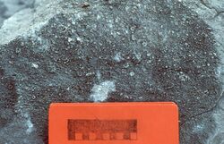
In central Pennsylvania, the basal "calico" limestone is a fossiliferous, medium-light- to medium-gray very thick bedded calcilutite containing numerous small irregular patches of clear calcite. The abundantly fossiliferous, nodular limestone at the base overlies the "calico". Overlying this is 5 to 6 m of fragmental calcarenite containing abundant crinoid columnals. Above the calcarenite is 6 m of fossiliferous, banded calcisiltite. The uppermost 15 m is a sequence alternating between laminated, stromatolitic calcisiltite, and calcilutite and calcisiltite that are argillaceous and fossiliferous.[3]
Depositional environment
The depositional environment of the Keyser is interpreted as shallow marine and tidal flats, occurring in cycles.[4]
Stratigraphy
Contact with Tonoloway Formation is probably conformable, but sharp enough to suggest an unconformity. Upper contact with the Old Port Formation is conformable.
The Keyser was divided into three members by J. W. Head in 1972.[5] These are, from lowest to highest, the Byers Island Member, Jersey Shore Member, and La Vale Member. The type locality of the Byers Island Member is at Selinsgrove, Pennsylvania, where it is 93 feet thick. The type locality of the Jersey Shore Member is at Jersey Shore, Lycoming County, Pennsylvania. The type locality of the La Vale Member is at the Corriganville quarry, Allegany County, Maryland, and is named for the nearby town of La Vale. This nomenclature is accepted by the USGS.
In Virginia and West Virginia the Keyser is divided into Upper and Lower Members by the Big Mountain Shale Member.[6]
Fossil content


- crinoid columnals
- stromatoporoids
- Brachiopods
- Tabulate corals
- Conodonts: Icriodus woschmidti,[6] Oulodus elegans, O. cristagalli[7]
Notable outcrops
- Keyser, West Virginia (type section), quarry and roadcut east of the town, on West Virginia.[8]
- Old Eldorado Quarry, at Mile Marker 30 along I-99/U.S. Route 220 in Blair County, Pennsylvania
- Alleghany Furnace Quarry, Altoona, Pennsylvania
- St. Clairsville/Osterburg Exit of I-99 in Bedford County, Pennsylvania (nearly vertical orientation)
- Abandoned quarry in Tyrone, Pennsylvania
- Quarry at Canoe Creek, Pennsylvania
- New Enterprise New Paris Quarry, Chestnut Ridge, Bedford County, Pennsylvania
- Roadcut along U.S. Route 30 (Everett bypass) through Warrior Ridge, Bedford County, Pennsylvania
- Strait Creek section on County Road 629, 1.5 miles south of U.S. Route 220, Strait Creek, Highland County, Virginia[6]
- Smoke Hole section on West Virginia Route 2, 1.5 miles west of U.S. Route 220, Pendleton County, West Virginia[6]
Age
Relative age dating places the Keyser in the late Silurian to early Devonian, with the transition occurring near the top of the formation. Denkler and Harris used conodont biostratigraphy to confirm this.[7]
See also
- List of types of limestone
- Cumberland Bone Cave
References
- ↑ Paleozoic Sedimentary Successions of the Virginia Valley & Ridge and Plateau
- ↑ Ulrich, E.O., 1911, Revision of the Paleozoic systems: Geological Society of America Bulletin, v. 22, p. 281-680
- ↑ Faill, R.T., Glover, A.D., and Way, J.H., 1989, Geology and mineral resources of the Blandburg, Tipton, Altoona, and Bellwood quadrangles, Blair, Cambria, Clearfield and Centre Counties, Pennsylvania: Pennsylvania Geological Survey Topographic and Geologic Atlas, 4th series, 86, 209 p., scale 1:24,000 and 1:48,000
- ↑ Anderson, E.J., Goodwin, P.W., and Sinclair, C.J., 2003, Facies and paleoenvironments of the Keyser Formation in the context of its cyclic structure, in Way, J.H., and others, eds., Geology on the edge: selected geology of Bedford, Blair, Cambria, and Somerset Counties, Guidebook, 68th Annual Field Conference of Pennsylvania Geologists, Altoona, PA, p. 1-18
- ↑ Head, J.W., III, 1972, Upper Silurian-Lower Devonian stratigraphy and nomenclature in the central Appalachians, IN Guidebook for the 37th annual field conference of Pennsylvania geologists: Field Conference of Pennsylvania Geologists, no. 37, p. 96-103.
- ↑ 6.0 6.1 6.2 6.3 Helfrich, C. T., 1978, A Conodont Fauna from the Keyser Limestone of Virginia and West Virginia, Journal of Paleontology, Vol. 52, No. 5 (Sep., 1978), pp. 1133-1142 [1]
- ↑ 7.0 7.1 Denkler, K.E. and Harris, A.G., 1988, Conodont-based determination of the Silurian-Devonian boundary in the Valley and Ridge province, northern and central Appalachians, U.S. Geological Survey Bulletin 1837-B [p. B1-B13] IN Sando, W.J., ed., Shorter contributions to paleontology and stratigraphy. [2]
- ↑ Previously, the quarry was exposed on County Route 8 in Mineral County, aka Waxler Road, but Waxler Road was moved to connect its more westward section to Route 46. The quarry is on private property, the site of the now closed Faulks Brothers Scrap Yard. It is visible on Google Maps at 39.43917865242232, -78.95964425171306 .
 |
 KSF
KSF