Nadir (topography)
Topic: Earth
 From HandWiki - Reading time: 3 min

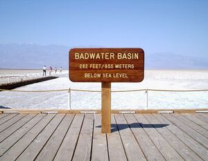
In topography, a nadir is a point on a surface that is lower in elevation than all points immediately adjacent to it. Mathematically, a nadir is a local minimum of elevation. A nadir may be the lowest point of a dry basin or depression, or the deepest point of a body of water or ice. The nadir of a body of water is often called a "deep", as in the Challenger Deep, the nadir of the Earth's oceans.
See also
- Depression (geology)
- Endorheic basin
- Geoid
- List of places on land with elevations below sea level
- Maxima and minima
- Summit (topography) (antonym)
- Topography
 |
Licensed under CC BY-SA 3.0 | Source: https://handwiki.org/wiki/Earth:Nadir_(topography)28 views | ↧ Download this article as ZWI file
 KSF
KSF