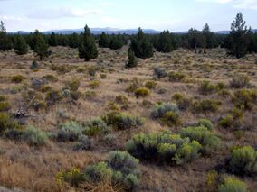
Oregon Badlands Wilderness
Topic: Earth
 From HandWiki - Reading time: 7 min
| Oregon Badlands Wilderness | |
|---|---|
IUCN category Ib (wilderness area) | |
 Oregon Badlands with sagebrush in bloom, Juniper trees, and proximity to Oregon Cascades | |
| Location | Deschutes / Crook counties, Oregon, United States |
| Nearest city | Bend, Oregon |
| Coordinates | [ ⚑ ] : 44°00′N 121°02′W / 44°N 121.04°W |
| Area | 29,301 acres (11,858 ha) |
| Established | United States Bureau of Land Management |
The Oregon Badlands Wilderness is a 29,301-acre (11,858 ha) wilderness area located east of Bend in Deschutes and Crook counties in the U.S. state of Oregon. The wilderness is managed by the Bureau of Land Management as part of the National Landscape Conservation System and was created by the Omnibus Public Land Management Act of 2009, which was signed into law by President Barack Obama on 30 March 2009.[1]
The area is known for igneous castle-like rock formations, harsh terrain, ancient Juniper trees, sagebrush, and extensive arid land. Desert wildflowers, dry river canyons, and Native American pictographs can be found.[2] The blind iditarod racer Rachel Scdoris trained in the area,[3] and the wilderness is home to the western terminus of the Oregon Desert Trail.[4][5]
Geology
The wilderness is situated on high desert terrain and is associated with a volcanic rootless shield.[6][7] This broad 10-to-12-kilometre (6.2 to 7.5 mi) volcanic shield issued lava from a rootless vent.[6] The lava flow dates to about 80,000 years old and comes from a main vent further up the slopes of Newberry Volcano.[6][8] This main vent was located near Lava Top Butte and the lava that came out of this vent travelled through the Arnold Lava Tube System to arrive at the current location of the Badlands.[6] An irregularly-shaped pit crater at the top of the shield marks the site where lava flowed in all directions to create the Badlands.[8] Lava tubes acted as conduits for the lava in some instances and are evidenced on the surface by tumuli, also known as pressure ridges.[7][9] Soils in the Badlands were largely formed from ash associated with the eruption of Mount Mazama some 7,700 years ago.[10][11]
It is the northwesternmost part of the Northern Basin and Range ecoregion, described as Pluvial Lake Basin, and shares many characteristics of the Great Basin.[12]
Ecology
Native vegetation in the Oregon Badlands Wilderness have adapted to the less than 12 inches (30 cm) of annual rainfall. Western juniper can live to be over 1,000 years old in the region. The oldest dated tree in Oregon – estimated to be over 1,600 years old – grows near the wilderness.[8]
Other common plants found in the Badlands wilderness include big sagebrush, rabbitbrush, and various bunchgrasses, including Idaho fescue and bluebunch wheatgrass. In the spring, the area blooms with a variety of wildflowers, including Oregon sunshine, dwarf monkeyflower, sulfur buckwheat, Indian paintbrush, and mariposa lily.[8]
The wilderness is home to a variety of wildlife, including black-tailed jackrabbit, mule deer, elk, pronghorn, cottontail rabbit, coyote, bats and six species of lizard. More than 100 species of bird live in the area, including golden eagle, sage grouse, and prairie falcon.[8]
Administration and stewardship
The Oregon Badlands Wilderness is administered by the Bureau of Land Management,[3] and is situated within the agency's Prineville District.[13] Before the wilderness designation, the Prineville District's BLM Liaison partnered with outside volunteers to develop physical restoration projects. These volunteers later incorporated as Friends of Oregon Badlands Wilderness after having donated over 1,200 hours of work mapping the area, repairing trailheads, installing kiosks and signs, and removing obsolete fencing that was a hazard to wildlife.[14] As of 2010, Friends of the Oregon Badlands Wilderness had used social media tools to organize over 200 Bend-area residents to execute these projects.[15]
In 2010, the BLM approved the retirement of a grazing permit called the Lynch Allotment, which allowed cattle grazing on a 2,971-acre (1,202 ha) parcel adjoining the wilderness. The parcel is part of a region called the Juniper Woodlands Special Management Area, and contains old-growth juniper home to deer and elk. The Oregon Natural Desert Foundation paid the value of the permit, roughly $10,000, to the compensate the rancher who previously grazed the parcel. The move was supported by adjoining landowners and the unanimous Deschutes County Commission. Because the grazing permit had limited demand and presented significant social and environmental conflicts, the Upper Deschutes Resource Management Plan[16] did not require the BLM to initiate a burdensome retirement process. According to ONDA, conflicts with hikers and equestrians contributed to the ranchers interest in retiring the permit.[17][18]
The Prineville District of the Bureau of Land Management is currently developing a management plan for the area. The plan is intended to provide guidance for "preserving and enhancing wilderness values while offering opportunities for solitude and primitive recreation, as well as managing other land uses and activities".[19]
Wilderness designation
The BLM designated the Oregon Badlands a wilderness study area in 1980,[20] and proposed federal wilderness designation for the Oregon Badlands in 1989.[21] Although there was popular local support for wilderness status in the years that followed,[22] issues such as grazing rights and off-highway vehicle (OHV) access were subjects of contention.
Wilderness designation was opposed by the Oregon Cattleman's Association and a non-profit group devoted to trail access for OHVs.[23] Among the groups that supported wilderness designation were the Oregon Natural Desert Association (ONDA), the Bend city commissioners,[24] and a rancher named Ray Clarno, who held a grazing permit within the proposed wilderness area. Clarno, alleging that off-road riders cut his fences and left cattle gates open, promised to retire his grazing rights if OHVs were barred from the area. He followed through on this promise in 2005, when the BLM banned OHVs from the Badlands.[20] ONDA estimated the cost of buying out grazing permits from a total of four affected ranchers at about $100,000.[23]
The proposed and final legislation designating the wilderness area included provisions for land swaps between private and public holders. The Central Oregon Irrigation District, which was neutral on the matter of the wilderness itself, supported the proposed legislation because it would benefit from the land swap.[23]
As of 1999, Oregon Senator Ron Wyden supported wilderness designation, and Oregon Senator Gordon H. Smith opposed it.[23] Because the Deschutes County commissioners disagreed about wilderness designation, the Deschutes County Commission ultimately took no official position on the issue.[25][26] The County Commission received 1,572 comments on the subject, with 75% of them favoring wilderness designation.[26]
Polls of Deschutes County residents conducted in 2002 and 2004 showed an increasing majority support for wilderness designation. In the 2004 poll, 57% of respondents favored the creation of a wilderness area, and 28% were opposed.[22] Wilderness designation was officially granted on 30 March 2009, with the passage of the Omnibus Public Land Management Act of 2009.
See also
- List of Oregon Wildernesses
- List of U.S. Wilderness Areas
References
- ↑ "Obama signs public lands reform bill". CNN. 30 March 2009. Archived from the original on 31 March 2009. https://web.archive.org/web/20090331220135/http://cnnwire.blogs.cnn.com/2009/03/30/obama-signs-public-lands-reform-bill/. Retrieved 30 March 2009.
- ↑ "Badlands Proposed Wilderness". Oregon Natural Desert Association. http://onda.org/defending-desert-wilderness/badlands-proposed-wilderness/badlands-proposed-wilderness. Retrieved 10 July 2008.
- ↑ 3.0 3.1 "Wyden announces wilderness legislation for Badlands in Deschutes County". Press Release of Senator Wyden. U.S. Senate newsroom. 27 May 2008. http://wyden.senate.gov/newsroom/press/release/?id=5f733e32-e635-406e-8a61-f30ca2eb0f37. Retrieved 10 July 2008.
- ↑ Morical, Mark (5 June 2013). "Bend hiker hopes to hike trail first". The Bulletin (Bend, Oregon). http://www.bendbulletin.com/article/20130605/NEWS0107/306050317/. Retrieved 6 June 2013.
- ↑ "Across the Oregon Desert Trail". Oregon Natural Desert Association. http://onda.org/where-we-work/oregon-desert-trail. Retrieved 6 June 2013.
- ↑ 6.0 6.1 6.2 6.3 Donnelly-Nolan, Julie M.. "Magnetic Excursion Recorded in Basalt at Newberry Volcano, Central Oregon".
- ↑ 7.0 7.1 "Deschutes & Ochoco National Forests". http://www.fs.fed.us/r6/centraloregon/geology/sites/badlands.shtml. Retrieved 18 August 2009.
- ↑ 8.0 8.1 8.2 8.3 8.4 Badlands Natural History - Oregon Natural Desert Association
- ↑ "Oregon High Desert Grotto". Skeels. http://www.ohdgrotto.com. Retrieved 6 August 2009.
- ↑ C. M. Zdanowicz; Zielinski, G. A.; Germani, M. S. (July 1999). "Mount Mazama eruption; calendrical age verified and atmospheric impact assessed". Geology 27 (7): 621–624. doi:10.1130/0091-7613(1999)027<0621:MMECAV>2.3.CO;2. Bibcode: 1999Geo....27..621Z. http://geology.geoscienceworld.org/cgi/content/abstract/27/7/621. Retrieved 15 November 2013. "Geochemical identification of Mount Mazama ash in the Greenland Ice Sheet Project 2 (GISP2) ice core gives a calendrical age of 7627 ± 150 cal yr B.P. (5677 ± 150 B.C.) for the eruption, thus providing a more accurate early Holocene stratigraphic time line than previously available.".
- ↑ "Badlands Wilderness Study Area Map and Guide". Oregon BLM. 8 March 2007. Archived from the original on 21 January 2009. https://web.archive.org/web/20090121021827/http://www.blm.gov/or/districts/prineville/files/pdo_badlands_brochure_03_01_2007.pdf.
- ↑ Southeast Oregon Resource Management Plan: Environmental Impact Statement. 1. Bureau of Land Management. 2001. p. 4. https://books.google.com/books?id=j_wxAQAAMAAJ&q=pluvial+lake+basin+badlands+oregon+-wiki&dq=pluvial+lake+basin+badlands+oregon+-wiki&hl=en&sa=X&ei=cvT2UaWwKKiCyQHxlYCoBg&ved=0CDAQ6AEwAA. Retrieved 29 July 2013.
- ↑ "Oregon Badlands Wilderness, Prineville District, OR". Bureau of Land Management. http://www.blm.gov/or/resources/recreation/site_info.php?siteid=399. Retrieved 15 May 2013.
- ↑ "Friends of the Oregon Badlands Wilderness (aka The Fobbits) and Gavin Hoban: Landscape Stewardship Certificate of Appreciation for 2009". The Public Lands Foundation. Archived from the original on 27 November 2010. https://web.archive.org/web/20101127085904/http://publicland.org/18_awards/land_steward_coa/LSCOA_09_fobbits.html. Retrieved 15 May 2013.
- ↑ Eidson, Lisa (April 2010). "Social Media in Wilderness Stewardship" (PDF). International Journal of Wilderness 16 (1): 33–36. http://ijw.org/wp-content/uploads/2010/08/Apr10-IJW-text-pgs-Vol16_no1.pdf#page=35. Retrieved 15 May 2013.
- ↑ "Upper Deschutes Resource Management Plan". BLM. September 2005. http://www.blm.gov/or/districts/prineville/plans/deschutesrmp/. Retrieved 11 June 2013.
- ↑ "Grazing permit near Badlands retired". The Bulletin. 29 September 2010. http://www.bendbulletin.com/apps/pbcs.dll/article?AID=/20100929/NEWS0107/9290350/1001/NEWS01&nav_category=NEWS01. Retrieved 6 June 2013.
- ↑ "Livestock Grazing Retired on 3,000 acres near the Oregon Badlands". Oregon Natural Desert Association. 28 September 2010. http://onda.org/pressroom/press-releases/grazing-retired-on-3-000-acres-near-the-oregon-badlands. Retrieved 6 June 2013.
- ↑ "Oregon Badlands Wilderness Management Plan: Public Meeting Notice and Request for Comments" (PDF). Bureau of Land Management. http://www.blm.gov/or/resources/recreation/badlands/files/2011-0030-EA-scoping-badlands.pdf. Retrieved 15 May 2013.
- ↑ 20.0 20.1 "Evolution of the Badlands, a Recipe for Success". Cascade Business News. http://www.cascadebusnews.com/archives/hot-news/480-evolution-of-the-badlands-a-recipe-for-success.
- ↑ Schechtel, Scott (February 2001). "Oregon's Badlands: Only The Lonely". Backpacker Magazine. Archived from the original on 14 April 2009. https://web.archive.org/web/20090414072812/http://www.backpacker.com/february_2001_destinations_oregon_badlands_wsa/destinations/1819. Retrieved 13 May 2013.
- ↑ 22.0 22.1 "Badlands wilderness backers cite poll support". Bend Bugle News. 14 May 2004. http://www.bendbugle.com/2004/05/badlands-wilderness-backers-cite-poll-support/. Retrieved 13 May 2013.
- ↑ 23.0 23.1 23.2 23.3 Odell, Rachel (28 April 2002). "The Badlands Wilderness preservation puzzle involves multiple parties". The Bulletin. Archived from the original on 30 March 2003. https://web.archive.org/web/20030330110138/http://www.traditionalmountaineering.org/News_Badlands_Designation.htm.
- ↑ Attig, Rick (3 April 1986). "Bend board endorses Badlands designation". The Bulletin. https://news.google.com/newspapers?nid=1243&dat=19860403&id=dJNTAAAAIBAJ&sjid=GocDAAAAIBAJ&pg=4274,4691841.
- ↑ Tom DeWolf, Chair, Deschutes County Commission (30 March 2005). "Deschutes County Commissioner DeWolf supports Badlands Wilderness". http://www.traditionalmountaineering.org/News_Badlands_DeWolf.htm. Retrieved 10 July 2008.
- ↑ 26.0 26.1 Barker, Chris (31 March 2005). "County takes no position on Badlands". The Bulletin. http://www.traditionalmountaineering.org/News_Badlands_County.htm.
External links
- Hiking the Badlands
- Badlands petroglyphs page 1 and page 2
- BLM Brochure and Trail Map (PDF)
- Oregon Badlands Wilderness Area - BLM page
 KSF
KSF

