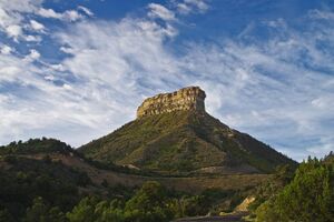
Point Lookout (Colorado)
Topic: Earth
 From HandWiki - Reading time: 2 min
| Point Lookout | |
|---|---|
 North aspect | |
| Highest point | |
| Elevation | 8,427 ft (2,569 m) [1] |
| Prominence | 607 ft (185 m) [2] |
| Parent peak | Park Point (8,571 ft)[2] |
| Isolation | 3.39 mi (5.46 km) [2] |
| Coordinates | [ ⚑ ] : 37°18′57″N 108°25′07″W / 37.3158286°N 108.4186979°W [3] |
| Geography | |
Lua error in Module:Location_map at line 522: Unable to find the specified location map definition: "Module:Location map/data/Colorado" does not exist.
| |
| Location | Mesa Verde National Park Montezuma County, Colorado, U.S. |
| Parent range | Colorado Plateau |
| Topo map | USGS Point Lookout |
| Geology | |
| Age of rock | Cretaceous |
| Type of rock | Point Lookout Sandstone |
| Climbing | |
| Easiest route | class 1 hiking trail[2] |
Point Lookout is an 8,427-foot (2,569 meter) elevation sandstone summit located in Mesa Verde National Park, in Montezuma County of southwest Colorado.[3] This prominent landmark is situated 2 miles (3.2 km) south of the park entrance, and 9.3 miles (15.0 km) east-southeast of the town of Cortez, and towers 1,600 feet above the surrounding terrain of Mancos Valley. Soldiers from Fort Lewis army post used its lofty position to send heliographic signals to troops campaigning in the west.[4] A trail climbs 2.2 miles (3.5 km) round-trip to the top and offers views of Montezuma and Mancos valleys, as well as the La Plata Mountains. This geographical feature's name was officially adopted in 1934 by the U.S. Board on Geographic Names.[3]
Geology
The main entrance road to Mesa Verde National Park traverses the east flank of Point Lookout as it climbs the escarpment of the East Rim of Mesa Verde. Point Lookout is located on the Colorado Plateau, and is composed of 400-foot thick Cretaceous Point Lookout Sandstone, which is the oldest of the three formations that make up the Mesaverde Group which is common to the Mesa Verde region.[5] The cliff-forming Point Lookout Sandstone overlays softer, slope-forming Mancos Shale, which is 2,000 feet thick and extends to the valley floor. Precipitation runoff from this feature drains into the San Juan River watershed.
Gallery
Climate
According to the Köppen climate classification system, Point Lookout is located in a Humid continental climate zone.[6] April through October are the most favorable months to visit.
Script error: No such module "weather box".
See also
- List of rock formations in the United States
References
- ↑ "Point Lookout, Colorado". http://www.peakbagger.com/peak.aspx?pid=3980.
- ↑ 2.0 2.1 2.2 2.3 "Point Lookout - 8,427' CO". https://listsofjohn.com/peak/4789. Retrieved 2020-11-25.
- ↑ 3.0 3.1 3.2 "Point Lookout". United States Geological Survey. https://geonames.usgs.gov/apex/f?p=gnispq:3:::NO::P3_FID:179078.
- ↑ Duane A. Smith, "Mesa Verde National Park", Arcadia Publishing, 2009.
- ↑ Ann G. Harris, Esther Tuttle, Sherwood D. Tuttle, "Geology of National Parks", 6th Ed., Kendall/Hunt Publishing, 2004.
- ↑ Peel, M. C.; Finlayson, B. L.; McMahon, T. A. (2007). "Updated world map of the Köppen−Geiger climate classification". Hydrol. Earth Syst. Sci. 11. ISSN 1027-5606.
- ↑ "PRISM Climate Group, Oregon State University". http://prism.oregonstate.edu/explorer/. Retrieved July 15, 2019.
External links
- Weather forecast: National Weather Service
 |
 KSF
KSF


