Table of Contents Categories
Bridgetown
Topic: Place
 From HandWiki - Reading time: 12 min
Bridgetown (UN/LOCODE: BB BGI)[1] is the capital and largest city of Barbados. Formerly The Town of Saint Michael, the Greater Bridgetown area is located within the parish of Saint Michael. Bridgetown is sometimes locally referred to as "The City", but the most common reference is simply "Town". As of 2014, its metropolitan population stands at roughly 110,000.
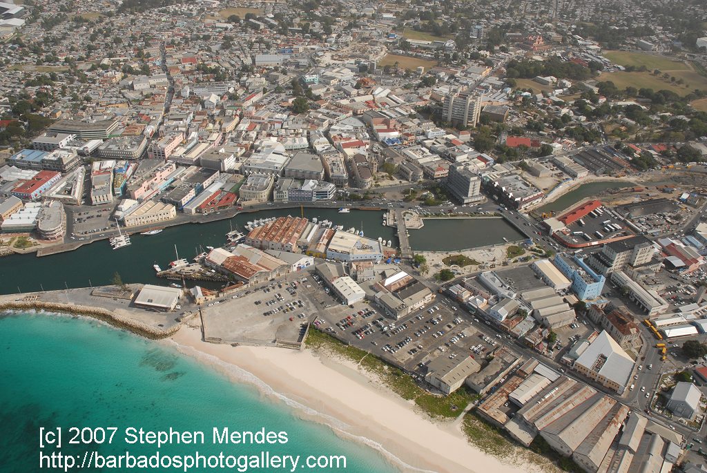
The Bridgetown port, found along Carlisle Bay (at [ ⚑ ] 13°06′22″N 59°37′55″W / 13.106°N 59.632°W) lies on the southwestern coast of the island. Parts of the Greater Bridgetown area (as roughly defined by the Ring Road Bypass or more commonly known as the ABC Highway),[2] sit close to the borders of the neighbouring parishes Christ Church and St. James. The Grantley Adams International Airport for Barbados, the only airport on the island, is located 16 kilometres (10 mi) southeast of Bridgetown city centre. It has daily flights to major cities in the United Kingdom, United States, Canada and the Caribbean. There is no longer a local municipal government, but it is a constituency of the national Parliament. During the short-lived 1950s-1960s Federation of the British West Indian Territories, Bridgetown was one of three capital cities[3] within the region being considered to be the Federal capital of the region.[4][5]
The present-day location of the city was established by English settlers in 1628; a previous settlement under the authority of Sir William Courten was at St. James Town. Bridgetown is a major West Indies tourist destination, and the city acts as an important financial, informatics, convention centre, and cruise ship port of call in the Caribbean region. On 25 June 2011, "Historic Bridgetown and its Garrison" was added as a World Heritage Site of UNESCO.[6][7][8]
History
Although the island was totally abandoned or uninhabited when the British arrived, one of the few traces of indigenous pre-existence on the island was a primitive bridge constructed over the Careenage area's swamp at the centre of Bridgetown. It was thought that this bridge was created by a people indigenous to the Caribbean known as the Tainos. Upon finding the structure, the British settlers began to call what is now the Bridgetown area Indian Bridge. Scholars widely believe that the Tainos were driven from Barbados to the neighbouring island of Saint Lucia, during an invasion by the Kalinagos, another indigenous people of the region. Eventually after 1654 when a new bridge was constructed over the Careenage by the British, the area became known as The Town of Saint Michael and later as Bridgetown, after Sir Tobias Bridge.[9]
Bridgetown is the only city outside the present United States that George Washington visited. (George Washington House, the house where he stayed, is included within the boundaries of the Garrison Historic Area.) Two of Washington's ancestors, Jonathon and Gerrard Hawtaine, were early planters on the island. Their grandmother was Mary Washington of Sulgrave, Northamptonshire, England. In 2011, historic buildings in Bridgetown were designated as a protected area by UNESCO.[10]
Early settlement

.jpg)
English settlement of Bridgetown began on 5 July 1628[11] under Charles Wolverstone, who brought with him 64 settlers to these lands formally claimed by James Hay, the Earl of Carlisle. Wolverstone had been sent by a group of London merchants, headed by Sir Marmaduke Rawdon. They had been granted a lease[12] to 10,000 acres (4,000 ha) of land by the Earl of Carlisle in settlement of debts. Wolverstone granted each of the settlers 100 acres (40 ha) of land on the northern side of the Careenage waterway for the purpose of general settlement.[11] The southern shore on Needham's Point was claimed by Carlisle's agents in October 1628. In 1631, many acres of land directly facing Carlisle Bay were passed to Henry Hawley, the new Governor; but after reports of his dishonest behaviour he was arrested and forcibly returned to England in 1639. An investigation by a commission in 1640 found that much of Hawley's land transactions were legitimate and properly showed[clarification needed] these lands (including the town site) as being attributed to the Earl of Carlisle. Bridgetown was built with a street layout resembling early English medieval or market towns, with its narrow serpentine street and alley configuration. It is estimated that between 1627 and 1807, approximately 387,000 enslaved Africans were sent to Barbados.[13]
From town to city
In 1824, Barbados became the seat of the Anglican Diocese of Barbados and the Leeward Islands. The St Michael's Parish Church became a cathedral, so that Bridgetown became a city. In 1842, Barbados, Trinidad, Tobago, Grenada, Saint Vincent, and Saint Lucia were split into separate dioceses by royal letters patent which also decreed that the Town of Bridgetown should be called the City of Bridgetown.[14]

Local government in Barbados did not last long. In April 1967, the local government councils were dissolved and replaced by an interim commissioner for local government. The Corporation of Bridgetown thus ceased to exist, and its records and paraphernalia were deposited in both the Government Department of Archives and Barbados Museum and Historical Society.[15] Today, Bridgetown and surrounding constituencies are administered by members of the Barbadian parliament.
Geography and climate
Geography

As established in the early 17th century, Bridgetown's centre was originally composed of a swamp, which was drained and filled in to make way for development.[16]
Boundaries
The earliest boundaries of Bridgetown are contained by way of an act passed on 4 April 1660 called, "to prevent the danger which may happen by fire, in or about any of the seaport towns of the Island".[11] The southern limit was declared to be the River (Careenage), whilst the western limit was declared to be the western boundary of St. Michael's (now St. Mary's) Churchyard, and extending in a direct line to the seaside. The town's other limits consisted of properties of certain citizens' names in this statute, the location of which cannot now be determined with certainty.[11] The boundaries were not redefined until 1822. [17]
Through Statutory Instrument (S.I) 1984 No. 141, Road Traffic Act, CAP. 295, ROAD TRAFFIC REGULATIONS, and under Schedule Sec. No. 6: The Boundaries of Bridgetown, Speightstown, Holetown and Oistin are cited as follows: 1) "City of Bridgetown" – "Bridgetown" – "The City":[18]
The area bounded by Highway 7 at the junction of Bay Street with Jemmotts Lane; thence in a north easterly and northerly direction following Jemmotts Lane, Martindales Road and Halls Road to the junction of Halls Road not including the said boundary roads; thence in a westerly direction following Tweedside Road and Roebuck Street to the junction of Country Road with Roebuck Street; thence in a northerly, westerly, and south-westerly direction following Country Road and Passage Road and Westbury Road to the junction of Westbury Road with President Kennedy Drive; thence in a southwesterly direction following President Kennedy Drive to its junction with Samuel Jackman Prescod Boulevard not including President Kennedy Drive; thence in a southerly and westerly direction following Samuel Jackman Prescod Boulevard to its junction with Princess Alice Highway not including Samuel Jackman Prescod Boulevard; thence continuing in a westerly direction to a point on the sea-coast; thence in a south-easterly direction following the sea coast to the junction of Bay Street with Jemmotts Lane.[citation needed]
Beyond the boundary outlined, the wider Greater Bridgetown metropolitan area technically occupies most of the parish of Saint Michael, an area which covers around 39 km2 (15 sq mi). The above portion for the Road Traffic Act also omits much of the 90 acres of new land originally formed by completion of the Port of Bridgetown in 1961.
Careenage
Climate
Bridgetown features a tropical savanna climate (Köppen Aw), with relatively constant temperatures throughout the course of the year. While fairly hot, Bridgetown is cooled somewhat by the trade winds that affect weather in Barbados in general. Bridgetown's record high of 33.1 °C (91.6 °F) in September 2005 and record low of 16.5 °C (61.7 °F) on 2 January 1984.[19] Bridgetown features distinct wet and dry seasons, with a relatively lengthy wet season and a shorter dry season. Its wet season is from June through December, while the dry season covers the remaining months.
| Bridgetown, Barbados | ||||||||||||||||||||||||||||||||||||||||||||||||||||||||||||
|---|---|---|---|---|---|---|---|---|---|---|---|---|---|---|---|---|---|---|---|---|---|---|---|---|---|---|---|---|---|---|---|---|---|---|---|---|---|---|---|---|---|---|---|---|---|---|---|---|---|---|---|---|---|---|---|---|---|---|---|---|
| Climate chart (explanation) | ||||||||||||||||||||||||||||||||||||||||||||||||||||||||||||
| ||||||||||||||||||||||||||||||||||||||||||||||||||||||||||||
| ||||||||||||||||||||||||||||||||||||||||||||||||||||||||||||
Script error: No such module "weather box".
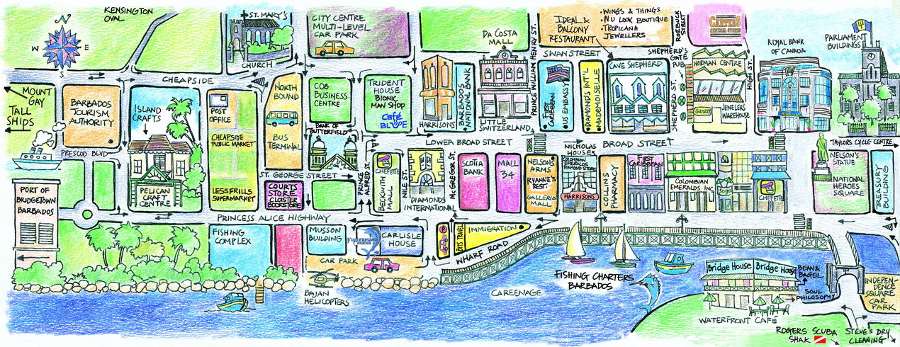
The City


- Swan Street – which is parallel to Broad Street, to the north.
- Roebuck Street – which leads towards Queens Park to the North, and East of Swan Street.
- Tudor Street – which comes from the north, intersects Swan Street and runs perpendicular to Broad Street.
- The Spring Garden Highway, which lies to the west of the city, plays host to over 85,000 bystanders and participants in the annual Grand Kadooment Carnival Parade.
Neighbourhoods
- Belleville
- Cat's Castle
- Cheapside
- Fontabelle
- Garden Land
- New Orleans
- Pinelands
- Strathclyde
- Weymouth
- Whitepark
Landmarks/points of interest
- National Heroes Square (formerly Trafalgar Square) and Fountain Garden[21]
.jpg)
- Independence Square and The Independence Arch
- The Montefiore Fountain
- Parliament Buildings of Barbados
- The Cathedral Church of Saint Michael and All Angels
- The St. Mary's Anglican Church
- The St. Patrick's Roman Catholic Cathedral
- Nidhe Israel Synagogue
- The Pelican Village and Craft Centre
- Queen's Park
- The Barbados Museum
- Kensington Oval (site of the 2007 Cricket World Cup final)
- Carlisle Bay Beach
- Cheapside market
- Rihanna Drive Monument
- The Tom Adams Financial Complex
- The Frank Collymore Hall of the Performing Arts
- The Cathedral Plaza
- The Cave Shepherd Department Store (No.10 Broad Street)
- The Mutual Building (lower Broad Street)
- The Cheapside Gardens
- Sagicor Plaza
- The Garrison Savannah and National Historic Area
- The Hilton Hotel
- Martineau House
- Pierhead Development Complex
Harbour
The Harbour port acts as one of the major shipping and transhipment hubs from international locations for the entire Eastern Caribbean. Recently, the Bridgetown Port was dredged to allow safe access and berthing for the new league of "super cruise ships". The dredging project was completed in 2002 and the city can now host many of the largest cruise ships in the world.

Society and culture


For a city of its size, the Greater Bridgetown area is home to several prestigious educational institutions. The city serves as the seat of one of the three campuses of the University of the West Indies in the northern suburb of Cave Hill. The campus sits on a bluff offering views of Bridgetown and its port. The Barbados Community College is located three miles (4.8 km) east of the Central Business District in a suburb known as "The Ivy", while the sprawling campus of the Samuel Jackman Prescod Polytechnic is located just beyond the eastern limits of the city in a suburb known as "The Pine". In addition, the city houses such distinguished secondary schools as Harrison College, Combermere and The St. Michael School. The American University of Barbados, School of Medicine located in Wildey area of the Parish of Saint Michael located roughly 4 km east of Bridgetown, it lies on the border with the Parish of Christ Church. The City of Bridgetown also played host to the 1994 United Nations Global Conference on Sustainable Development of Small Islands States. Bridgetown has branches of some of the largest banks in the world and English-speaking Caribbean and is internationally recognised as an emerging financial domicile. The city underwent considerable redevelopment in preparation for the 2007 World Cricket Cup Finals held at the historic Kensington Oval. The stadium was renovated to a state-of-the-art sports facility accommodating 30,000 spectators. Live viewership for the 2007 event was estimated to be over 100 million people worldwide.[22]
Utilities and local services

- Electricity – Barbados Light and Power Company Ltd. (BL&P)
- Natural Gas – National Petroleum Corporation
- Water – Barbados Water Authority (BWA)
- Telecommunications – Digicel, FLOW, and WIISCOM
- Television – CBC TV 8, Multi-Choice TV (Barbados), and DirecTV
- Radio – List of radio stations in Barbados
- Barbadian media
Economy
Barbados' main exports are sugar, rum, and molasses. The island is also involved in other industries namely tourism and the offshore sector.[23]
Stock exchange
Business/specifics
Business: Banks are open 08:00–15:00, Hours: Monday to Thursday, and 08:00–17:00 on Fridays.
- Bank of Nova Scotia,
- Republic Bank,
- Canadian Imperial Bank of Commerce (CIBC) (see FirstCaribbean International Bank),
- First Citizens and
- Royal Bank of Canada (RBC)
Automatic Teller Machines are available.
Shops are open:
- 08:00–18:00 weekdays and
- 08:00–12:00 Saturdays.
Payment cards are widely accepted.
Electricity: 115 volts AC, 50 cycles. Most hotels have 220 AC.
Telecommunications: the international dialling code for Barbados is +1.246 followed by seven digits. On the island, use the seven digits alone. When on the island, to call anywhere in the United States or Canada simply dial +1 (area code) + seven digit phone number.
Emergency numbers: Police: 211 (emergency only) Fire: 311 Ambulance: 511 Coast Guard and Defense Force: +1.246.427.8819
Transportation
All seven of Barbados's primary highways begin close to the City of Bridgetown, in the Parish of Saint Michael. They all fan out to the north, south and east to other parts of the island. Driving is done of the left-hand side of the road with a speed limit of 60 km/h (37 mph) in built-up areas. The speed limit on the ABC Highway is generally 80 km/h (50 mph) except in built-up areas. Water transport is regulated by the Barbados Port Authority.
Public buses
Route taxis
Diplomatic missions in Barbados
Twin towns – sister cities
Bridgetown is twinned with:
 Bridgetown, Nova Scotia, Canada (9 July 2004)[24]
 Hackney, United Kingdom (1982)[25]
- Template:Country data CN Hunan province, China (2023)[26][27]
 New York City, New York, United States (22 October 2024)[28]
- Wilmington, North Carolina, United States (28 June 2004)[29]
Notable people

- Jofra Archer, cricketer
- Stede Bonnet, pirate, sometimes called "The Gentleman Pirate"
- Richard Clement Moody, founder of British Columbia.
- Gilbert Elliott (1870–unknown), first-class cricketer
- Anthony Forde, darts player
- Grandmaster Flash, rapper
- Orlando Greene, Olympic runner[30]
- Dawn-Marie Layne, cricketer
- Zane Maloney, racecar driver and 2019 British F4 champion
- Malcolm Marshall, cricketer
- Jackie Opel, credited as creator of experimental syncopated music genre called Spouge.
- Rihanna, singer-songwriter
- Kyffin Simpson racecar driver and 2021 Formula Regional Americas champion
- Sir Garfield Sobers, cricketer
- Sir Clyde Walcott, cricketer
- Sir Everton Weekes, cricketer
- Sir Frank Worrell, cricketer
- Dame Sandra Mason, First President of Barbados.
See also
- Demographics of Barbados
- List of cities in Barbados
- List of cities in the Caribbean
- List of metropolitan areas in the West Indies
- Parishes of Barbados
- Transportation in Barbados
References
- ↑ Barbados codes, United Nations – Code for Trade and Transport Locations (UN/LOCODE) via UNECE
- ↑ "Restore priority of B'town Redevelopment Plan". The Barbados Advocate. 21 March 2012. http://www.barbadosadvocate.com/newsitem.asp?more=letters&NewsID=23551.
- ↑ Nantambu, Dr. Kwame (12 December 2005). "W.I. Federation: Failure From the Start". Trinicenter.com. http://www.trinicenter.com/kwame/2010/1505.htm.
- ↑ Kasperson, Roger E.; Minghi, Julian V. (2011). "Decision Making". The Structure of Political Geography. New Brunswick, NJ: Transaction Publishers. pp. 350–365. ISBN 978-1-4128-1854-4.
- ↑ Lewis, Gordon K. (2004). The Growth of the Modern West Indies. pp. 350–365. ISBN 976-637-171-7.
- ↑ "Barbados enters World Heritage List with Bridgetown and its Garrison; Hiraizumi (Japan) and Germany's Beech Forests also inscribed". UNESCOPRESS. UNESCO. 25 June 2011. http://www.unesco.org/new/en/media-services/single-view/news/barbados_enters_world_heritage_list_with_bridgetown_and_its_garrison_hiraizumi_japan_and_germanys_beech_forests_also_inscribed/. "The World Heritage Committee has inscribed three new sites on UNESCO’s World Heritage List so far today: the Ancient Beech Forests of Germany as an extension to the World Heritage site of Primeval Beech Forests of the Carpathians (Slovakia, Ukraine), Historic Bridgetown and its Garrison, the first heritage site of Barbados to enter the World Heritage List; and Hiraizumi – Temples, Gardens and Archaeological Sites"
- ↑ Ramsay, Allison (26 June 2011). "Barbados makes the list!". The Barbados Advocate. http://www.barbadosadvocate.com/newsitem.asp?more=local&NewsID=18380. "Historic Bridgetown and its Garrison site was considered for nomination after Barbados became signatory to the UNESCO Convention for the Protection of World Cultural and Natural Heritage Convention in 2002. Barbados submitted the nomination dossier to UNESCO World Heritage Centre on February 1, 2009, and that was among 45 proposals which were examined by the World Heritage Committee in June 2010. A total of 35 nominations including natural, cultural and mixed properties are being reviewed by the Committee. The session will end on 29 June."
- ↑ "Historic Bridgetown now a World Heritage Site". Caribbean Broadcasting Corporation (CBC). 26 June 2011. http://www.cbc.bb/index.php?option=com_content&view=article&id=2075:historic-bridgetown-now-a-world-heritage-site&catid=36:local-news&Itemid=59. "The World Heritage Committee, meeting in Paris, said Bridgetown and its garrison deserved a place on the List, which is comprised of more than 900 cultural or natural sites around the world regarded as having outstanding universal value.."
- ↑ Pape, Thomas (1938). Newcastle-under-Lyme in Tudor and early Stuart times. Manchester University Press. p. 150. https://books.google.com/books?id=ExwNAQAAIAAJ&pg=PA150. Retrieved 9 October 2025.
- ↑ Staff writer (29 June 2011). "Guard our heritage". The Barbados Advocate. http://www.barbadosadvocate.com/newsitem.asp?more=editorial&NewsID=18426. "The World Heritage Committee (WHC) determined that historic Bridgetown and its Garrison fulfil the following roles: 1) "exhibit an important interchange of human values, over a span of time or within a cultural area of the world, on developments in architecture or technology, monumental arts, town-planning or landscape design; 2) bear a unique or at least exceptional testimony to a cultural tradition or to a civilisation which is living or which has disappeared; 3) be an outstanding example of a type of building, architectural or technological ensemble or landscape which illustrates (a) significant stage(s) in human history"."
- ↑ 11.0 11.1 11.2 11.3 Alleyne, Warren (1978). "I "The Beginning"". Historic Bridgetown. The Barbados National Trust. pp. 7, 8.
- ↑ Carrington, Sean; Fraser, Henry (2003). "Settlement of Barbados". A~Z of Barbados Heritage. Macmillan Caribbean. pp. 185–186. ISBN 0-333-92068-6.
- ↑ "BBC - History - British History in depth: Slavery and Economy in Barbados" (in en-GB). https://www.bbc.co.uk/history/british/empire_seapower/barbados_01.shtml. "It is estimated that between 1627 to 1807, some 387 000 Africans were shipped to the island against their will, in overcrowded, unsanitary ships, which made the Middle Passage a synonym for barbaric horror."
- ↑ No. 20146. 30 September 1842. p. 2631. https://www.thegazette.co.uk/London/issue/20146/page/2631
- ↑ Alleyne, Warren (1978). Historic Bridgetown. Barbados: The Barbados National Trust.
- ↑ Smith, S.D. (2007-01-01). "Paying the levy: Taxable wealth in Bridgetown, Barbados, 1680–1715". The History of the Family 12 (2): 116–129. doi:10.1016/j.hisfam.2007.08.004. ISSN 1081-602X. https://www.tandfonline.com/doi/abs/10.1016/j.hisfam.2007.08.004.
- ↑ "1376-ICOMOS-1786-en.pdf". ICOMOS. https://whc.unesco.org/document/152514&usg=AOvVaw1aoTJqbiHCgPe54yjz2sUF&opi=89978449.
- ↑ "Road Traffic Act". http://208.109.177.6/en/showdoc/cr/1984_141/se:105?splitmode=true#Pd61946487e5056.
- ↑ 19.0 19.1 "Barbados Weather Climate Data". Barbados Meteorological Services. http://www.barbadosweather.org/barbados-weather-climate-data.php.
- ↑ "Station Grantley" (in fr). Meteo Climat. http://meteo-climat-bzh.dyndns.org/index.php?page=stati&id=1505.
- ↑ "Trafalgar Square". http://www.funbarbados.com/Sights/S_trafalgarsquare.CFM.
- ↑ Mukherjee, Sharmistha (25 March 2011). "ICC Cricket World Cup draws record viewership". Business Standard. http://www.sify.com/finance/icc-cricket-world-cup-draws-record-viewership-news-equity-ldzbb5gebaf.html.
- ↑ Centre, UNESCO World Heritage. "The Industrial Heritage of Barbados: The Story of Sugar and Rum" (in en). https://whc.unesco.org/en/tentativelists/5942/.
- ↑ Miller, Dame Billie (2004-07-09). "Remarks by Senior Minister Dame Billie Miller at the Signing Ceremony on the Occasion of the Twinning of Bridgetown, Nova Scotia and Bridgetown, Barbados". Ministry of Foreign Affairs, Foreign Trade and International Business (Barbados). Bridgetown, N.S., Canada. http://www.foreign.gov.bb/Userfiles/File/B'town,%20B'dos%20&%20B'town,%20Nova%20Scotia%20-%20Twinning%20%20July%2009.%202004.pdf.
- ↑ "Twinning | Hackney Council". https://hackney.gov.uk/twinning/.
- ↑ Jiangjiang, Yu, ed (June 26, 2023). "Hunan, Bridgetown Establish Friendship Province-city Ties". Hunan Provincial People's Government. http://www.enghunan.gov.cn/hneng/News/Localnews/202306/t20230626_29384578.html.
- ↑ "Hunan's International Sister Cities at the Provincial Level". Hunan Provincial People's Government. http://www.enghunan.gov.cn/hneng/AboutHunan/GlobalAssociations/SisterCities/201508/t20150811_1817678.html
- ↑ Austin, Sharon (2024-10-22). "Sister-City Agreement Between Bridgetown & New York Signed" (in en-US). https://gisbarbados.gov.bb/blog/sister-city-agreement-between-bridgetown-new-york-signed/.
- ↑ "Wilmington's Sister Cities". http://www.scawilmington.org/Barbados.html.
- ↑ Fox, Scarlett (22 October 2012). "Newsome Coach Orlando Greene: From Caribbean To Olympian". http://fl.milesplit.com/articles/94526/newsome-coach-orlando-greene-from-caribbean-to-olympian.
Further reading
Maps
UNESCO World Heritage site
- World Heritage Sites in Barbados, UNESCO
- Map showing area designated as Historic Bridgetown and the Garrison, UNESCO
- The Importance of Bridgetown in the New world – The UNESCO World Heritage Centre website
- Historic Bridgetown and Its Garrison on Facebook
External links
Template:North American capitals
 |
 EncycloReader
is supported by the
EncycloReader
is supported by the