Regions of Lithuania
Topic: Place
 From HandWiki - Reading time: 4 min


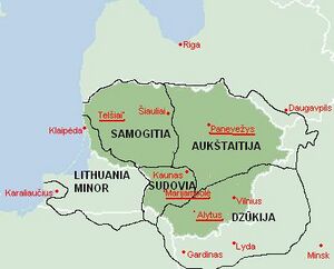
Lithuania can be divided into historical and cultural regions (called ethnographic regions). The exact borders are not fully clear, as the regions are not official political or administrative units. They are delimited by culture, such as country traditions, traditional lifestyle, songs, tales, etc. To some extent regions correspond to the zones of Lithuanian language dialects. This correspondence, however, is by no means strict. For example, although the Dzūkian dialect is called South Aukštaitian, it does not mean that Dzūkija is part of Aukštaitija. In certain parts of some regions, dialects of other regions are spoken, while for example in Samogitia, there are three indigenous dialects (southern, northern and western Samogitian), some of which are subdivided into subdialects.[1]
Regions in politics
No region, except for Samogitia, has ever been a political or an administrative entity. However, some work was done recently to delimit their boundaries more clearly, as there is a project to change the system of counties in Lithuania into ethnographic regions, which would be called lands (singular - žemė, plural - žemės). This project is also supported by the view that with the limited functions of counties, 10 of them are not needed for Lithuania. Another supporting argument is that in other countries historical territories are being revived, while in Lithuania artificially made counties exist. The project was supported by the former president Rolandas Paksas, yet now it is not clear when or if the project will be completed at all. However, Dzūkija quite recently adopted the coat of arms and emblem which would be used in case the reform were to be implemented. Alytus County, which lies almost entirely within Dzūkija, adopted soon thereafter a coat of arms that is based on the Dzūkija coat of arms. Samogitia has a flag and a coat of arms dating from the time of the Duchy of Samogitia; these symbols are considerably older than the flag of Lithuania. Lithuania Minor has a flag used since the 17th century, and an anthem originating from the 19th century. However, if the reform were to be implemented, most likely there would be just 4 lands, not 5, because most of Lithuania minor is located within the modern borders of Russia (in the Kaliningrad Oblast) and many Lithuanians were expelled from there. The relatively small remaining part is also populated mostly by relative newcomers, as much of the local population died in the Second World War or was expelled. Therefore, Lithuania minor would probably be attached to Samogitia.
Despite the fact that the regions are not political/administrative entities, most regions have their "capitals" (cities which are commonly considered to be capitals). These cities are not necessarily the largest in the region.
NUTS-2 statistical regions
In 2016, Seimas announced the creation of new NUTS-2 regions for Lithuania: "Sostinės regionas" or "capital region", and "Vidurio ir vakarų Lietuvos regionas" or "middle and western Lithuania".[2] The new regions were approved by the European parliament on 21 November 2016.
Capital region covers a land area of 9,731 km2 and has a population of approximately 0.8 million people. The middle and western region Lithuania covers a land area of 55,569 km2 and has a population of approximately 2.0 million people[3].
In 2018, the capital region had a GDP per capita of €23,000 and a total GDP of €19 billion. The middle and western Lithuania region had a GDP per capita of €13,000 and total GDP of €26 billion.[4][5]
List of regions
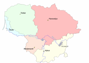
- Aukštaitija (Literally Highlands). Region in northeastern Lithuania, also includes some historical Lithuanian territories of southwestern Latvia and northwestern Belarus . Capital Panevėžys, it is also largest city of region.
- Samogitia, (Žemaitija, literally Lowlands). Region in western Lithuania. Capital is Telšiai, largest city is Šiauliai.
- Dzūkija (Dzūkija or Dainava (the latter name literally means "Land of songs")). Region in the southeast of Lithuania, also includes vast historically Lithuanian territories of Belarus , and some territories of Poland . Capital is Alytus, largest city is Vilnius.
- Suvalkija (Sūduva or Suvalkija). Region in the southwest of Lithuania, the smallest ethnographic region. Capital is Marijampolė, largest city - Kaunas.
- Lithuania Minor (Mažoji Lietuva). Region at the Baltic sea coast, also includes territories with large historical Lithuanian population of what is now Kaliningrad Oblast and a bit of northern Poland . Largest city is Klaipėda.
See also
- Counties of Lithuania
- Ethnographic Lithuania
- Geography of Lithuania
- Historical regions of Central Europe
References
- ↑ ThingLink. "AUKŠTAITIJA by baltvile" (in en). https://www.thinglink.com/scene/370999704114167810.
- ↑ "Dėl Sostinės bei Vidurio ir vakarų Lietuvos regionų statistinių rodiklių skelbimo ir perdavimo Europos Komisijai (Eurostatui) - Naujienos - Lietuvos statistikos departamentas - Oficialiosios statistikos portalas" (in Lithuanian). https://www.stat.gov.lt/home/-/asset_publisher/lbrXvLVHX2ln/content/del-sostines-bei-vidurio-ir-vakaru-lietuvos-regionu-statistiniu-rodikliu-skelbimo-ir-perdavimo-europos-komisijai-eurostatui-?inheritRedirect=false.
- ↑ https://osp.stat.gov.lt/documents/10180/3329771/Population.pdf&ved=2ahUKEwjQ9Mu0sqniAhXhk4sKHaYXCPkQFjALegQIBRAF&usg=AOvVaw2qBxMzbr24oDoK07xY-VH5&cshid=1558330751138
- ↑ https://ec.europa.eu/eurostat/documents/2995521/9618249/1-26022019-AP-EN.pdf/f765d183-c3d2-4e2f-9256-cc6665909c80
- ↑ https://osp.stat.gov.lt/informaciniai-pranesimai?articleId=7016550
 KSF
KSF