GenGIS
Topic: Software
 From HandWiki - Reading time: 1 min
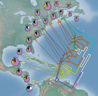
 Biodiversity of 19 marine metagenomes from the Global Ocean Sampling Expedition. | |
| Developer(s) | Donovan Parks, Mike Porter, Timothy Mankowski, Suwen Wang, Sylvia Churcher, Alex Keddy, Christian Blouin, Jacqueline Whalley, Stephen Brooks, Rob Beiko |
|---|---|
| Stable release | 2.5.3
/ 22 April 2017 |
| Operating system | Windows, Mac OS X |
| Type | Bioinformatics |
| License | GPL v3 |
| Website | kiwi |
GenGIS[1] merges geographic, ecological and phylogenetic biodiversity data in a single interactive visualization and analysis environment. A key feature of GenGIS is the testing of geographic axes that can correspond to routes of migration or gradients that influence community similarity.[2] Data can also be explored using graphical summaries of data on a site-by-site basis, as 3D geophylogenies, or custom visualizations developed using a plugin framework. Standard statistical test such as linear regression and Mantel are provided, and the R statistical language can be accessed directly within GenGIS. Since its release, GenGIS has been used to investigate the phylogeography of viruses and bacteriophages, bacteria, and eukaryotes.
See also
References
- ↑ Parks, DH; Porter M; Churcher S; Wang S; Blouin C; Whalley J; Brooks S; Beiko RG (2009). "GenGIS: A geospatial information system for genomic data". Genome Research 19 (10): 1896–1904. doi:10.1101/gr.095612.109. PMID 19635847.
- ↑ Parks, DH; Beiko RG (2009). "Quantitative visualizations of hierarchically organized data in a geographic context". 2009 17th International Conference on Geoinformatics. 1–6. doi:10.1109/GEOINFORMATICS.2009.5293552. ISBN 978-1-4244-4562-2.
External links
 |
Licensed under CC BY-SA 3.0 | Source: https://handwiki.org/wiki/Software:GenGIS7 views | Status: cached on August 17 2024 05:00:29↧ Download this article as ZWI file
 KSF
KSF