Categories
Barpeta district
 From Wikipedia - Reading time: 12 min
Barpeta district | |
|---|---|
District of Assam | |
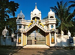 Patbaushi Satra, Barpeta | |
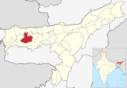 Location in Assam | |
 Barpeta district | |
| Coordinates: 26°32′N 91°00′E / 26.533°N 91.000°E | |
| Country | |
| State | Assam |
| Division | Lower Assam |
| Headquarters | Barpeta |
| Government | |
| • Lok Sabha constituencies | Barpeta |
| • Vidhan Sabha constituencies | Sorbhog, Barpeta, Jania, Baghbar, Sarukhetri, Chenga |
| Area | |
• Total | 2,764 km2 (1,067 sq mi) |
| Population (2011) | |
• Total | 1,439,806 |
| • Density | 520/km2 (1,300/sq mi) |
| Time zone | UTC+05:30 (IST) |
| ISO 3166 code | IN-AS-BA |
| Website | https://barpeta.assam.gov.in/ |
Barpeta district is an administrative district in the state of Assam in India. The district headquarters are located at Barpeta. The district occupies an area of 3,245 km2 (1,253 sq mi) and has a population of 1,642,420 (as of 2001).
History
[edit]
Barpeta district was created in 1983 when it was split from Kamrup district.[1] In 2020, Bajali subdivision was split from Barpeta to be a fully-fledged district.[2]
Geography
[edit]Barpeta district occupies an area of 3,245 square kilometres (1,253 sq mi),[3] comparatively equivalent to Russia's Iturup Island.[4]
Important villages and towns of the district
[edit]This section does not cite any sources. (October 2019) |
These are the important cities/towns of the district:
- Barpeta
- The headquarters and the second largest town in the district. The town is surrounded by rivulets and canals from all directions. The important centre of attraction is the Barpeta satra established by Vaishnavite saint Madhabdev.
- Howly
- The middle town of the district between Barpeta Road and Barpeta Town. It is a busy commercial town that is also known as the business capital of the district.
- Barpeta Road
- The largest town of the district. It is a busy commercial town that is also known as the business capital of western Assam.
- Bhaktardoba
- Bhaktardoba is a Bazaar located in Barpeta district in the state of Assam, India.
- Sarbhog
- A small town along National Highway no. 31.
- Bahari
- It is situated in the southeast corner of Barpeta, near about 20 km away from the main town. Brahmaputra river flows on the southern side of Bahari. It is also the commercial hub for the entire southeastern part of the Barpeta district. Bahari is also famous for the Satra which is established by Mahapurux Sri Sri Haridev.
- Sarthebari
- A small town known for its bell-metal works.
- Kalgachia
- A Town in the west of the district
- Barbhitha
- A village of the southwest border of Barpeta district.
- Mandia
- Mandia is another town in the south part of the district.
Joypur Bazar
An important Bazar Of Barpeta District
These are the important Vallage of the district:
Jashihati
One Of Tha Best Vallage Of BARPETA Distric
Educational institution
[edit]Fakhruddin Ali Ahmed Medical College and Hospital (FAAMCH) is the fifth medical college of Assam based in Barpeta.[1] The college has been named after former President of India Fakhruddin Ali Ahmed. The classes were formally inaugurated in August 2012 by then health minister of Assam, Himanta Biswa Sarma, after it received the permission from the Medical Council of India even though the hospital section was inaugurated on 11 February 2011.[2][3]
Schools
[edit]Assam board
[edit]- Harendra Chitra College, Bhaktardoba also known as H.C. College, is an undergraduate college established in the year 1992 at Bhaktardoba of Barpeta district in Assam.
- Barbhitha High School, established in 1947, located in the southwestern part of Barpeta District
- K. K. Pathak High School, Kalgachia, established in 1975, located in Kalgachia town in the western part of Barpeta district
- Padmapara High School, established in 1981, located in Padmapara village in the southeastern part of Barpeta district
CBSE
[edit]- Adarsh Vidyalaya, Dahalapara
- Adarsh Vidyalaya, Mandia
- Adarsh Vidyalaya, Ganakkuchi
- Adarsh Vidyalaya, Chenga Village
- Adarsh Vidyalaya, Pakabetbari
- Adarsh Vidyalaya, Gomafulbari
- Jawahar Navodaya Vidyalaya
- Kendriya Vidyalaya, Barpeta
- Christ Jyoti School
- Don Bosco School
- Manas Valley Academy
- Pathsala Public School
- Sreeram Academ
- Kishalay Shishu Niketan, Sarupeta, Established In 1993 Located In Sarupeta
Economy
[edit]In 2006 the Indian government named Barpeta one of the country's 250 most backward districts (out of a total of 640).[5] It is one of the eleven districts in Assam currently receiving funds from the Backward Regions Grant Fund Programme (BRGF).[5]
Divisions
[edit]There are eight Assam Legislative Assembly constituencies in this district: Barpeta, Baghbor, Bhawanipur, Chenga, Jania, Patacharkuchi, Sarukhetri, Sorbhog.[6] Sorbhog is in the Kokrajhar Lok Sabha constituency, whilst the other seven are in the Barpeta Lok Sabha constituency.[7]
Demographics
[edit]| Year | Pop. | ±% p.a. |
|---|---|---|
| 1901 | 100,258 | — |
| 1911 | 120,332 | +1.84% |
| 1921 | 161,292 | +2.97% |
| 1931 | 272,623 | +5.39% |
| 1941 | 392,750 | +3.72% |
| 1951 | 466,475 | +1.74% |
| 1961 | 607,434 | +2.68% |
| 1971 | 828,404 | +3.15% |
| 1991 | 1,163,166 | +1.71% |
| 2001 | 1,394,755 | +1.83% |
| 2011 | 1,693,622 | +1.96% |
| source:[8] | ||
According to the 2011 census, the Barpeta district has a population of 1,693,622,[9] roughly equal to the nation of Guinea-Bissau[10] or the US state of Idaho.[11] This gives it a ranking of 292nd in India (out of a total of 640.)[9] The district has a population density of 632 inhabitants per square kilometre (1,640/sq mi).[9] Its population growth rate over the decade 2001–2011 was 21.4%.[9] Barpeta has a sex ratio of 951 females for every 1000 males,[9] and a literacy rate of 65.03%.[9]
The divided district has a population of 1,439,806, of which 136,111 (9.45%) live in urban areas. Barpeta has a sex ratio of 949 females per 1000 males. Scheduled Castes and Scheduled Tribes make up 76,128 (5.29%) and 15,858 (1.10%) of the population respectively.[9]
Languages
[edit]- Bengali (68.9%)
- Assamese (29.4%)
- Boro (1.03%)
- Others (0.69%)
At the time of the 2011 census in the residual district, 68.89% of the population spoke Bengali, 29.39% Assamese and 1.03% Bodo as their first language.[12]
Religions
[edit]In Barpeta district, as per the 2011 Indian census, Islam is the most followed religion with 1,117,033 (77.58%) adherents, while Hinduism is followed by 320,578 (22.27%) of the population. Small percentages of followers of Sikhism, Jainism and Buddhism are also present. Muslims are mainly rural and form over 83% of the rural population, while Hindus are majority in urban areas.[13] Way back in 1971, Hindus were slight majority in Barpeta district with forming 51.1% of the population, while Muslims were 48.6% at that time.[14]
| Circle | Muslims | Hindus | Others |
|---|---|---|---|
| Barnagar (Pt) | 49.48% | 50.15% | 0.37% |
| Kalgachia | 99.22% | 0.71% | 0.07% |
| Baghbor | 96.38% | 3.53% | 0.09% |
| Chenga | 84.15% | 15.76% | 0.09% |
| Barpeta | 76.49% | 23.37% | 0.14% |
| Sarthebari | 57.32% | 42.53% | 0.15% |
References
[edit]- ^ Law, Gwillim (25 September 2011). "Districts of India". Statoids. Retrieved 11 October 2011.
- ^ "Bajali Civil Sub-Division to a full-fledged district facing a new hurdle - Sentinelassam". The Sentinel. 10 September 2020. Retrieved 31 October 2020.
- ^ Srivastava, Dayawanti et al. (ed.) (2010). "States and Union Territories: Assam: Government". India 2010: A Reference Annual (54th ed.). New Delhi, India: Additional Director General, Publications Division, Ministry of Information and Broadcasting (India), Government of India. p. 1116. ISBN 978-81-230-1617-7.
{{cite book}}:|last1=has generic name (help) - ^ "Island Directory Tables: Islands by Land Area". United Nations Environment Program. 18 February 1998. Archived from the original on 1 December 2015. Retrieved 11 October 2011.
Iturup (Etorofu) 3,238km2
- ^ a b Ministry of Panchayati Raj (8 September 2009). "A Note on the Backward Regions Grant Fund Programme" (PDF). National Institute of Rural Development. Archived from the original (PDF) on 5 April 2012. Retrieved 27 September 2011.
- ^ "List of Assembly Constituencies showing their Revenue & Election District wise break – up" (PDF). Chief Electoral Officer, Assam website. Archived from the original (PDF) on 22 March 2012. Retrieved 26 September 2011.
- ^ "List of Assembly Constituencies showing their Parliamentary Constituencies wise break – up" (PDF). Chief Electoral Officer, Assam website. Archived from the original (PDF) on 22 March 2012. Retrieved 26 September 2011.
- ^ Decadal Variation In Population Since 1901
- ^ a b c d e f g "District Census Handbook: Barpeta" (PDF). censusindia.gov.in. Registrar General and Census Commissioner of India. 2011.
- ^ US Directorate of Intelligence. "Country Comparison:Population". Archived from the original on 13 June 2007. Retrieved 1 October 2011.
Guinea-Bissau 1,596,677 July 2011 est.
- ^ "2010 Resident Population Data". U.S. Census Bureau. Archived from the original on 19 October 2013. Retrieved 30 September 2011.
Idaho 1,567,582
- ^ a b "Table C-16 Population By Mother Tongue: Assam". censusindia.gov.in. Registrar General and Census Commissioner of India. 2011.
- ^ a b "Table C-01 Population By Religion: Assam". census.gov.in. Registrar General and Census Commissioner of India. 2011.
- ^ International Journal of Scientific and Research Publications https://www.ijsrp.org › ijsrp-...PDF The Change of Religion and Language Composition in the State of Assam ...
See also
[edit]- Chapar Bori
External links
[edit]Places adjacent to Barpeta district | ||||||||||||||||
|---|---|---|---|---|---|---|---|---|---|---|---|---|---|---|---|---|
| ||||||||||||||||
Capital: Dispur | |||||||||||
| State symbols |
| ||||||||||
| Topics |
| ||||||||||
| History |
| ||||||||||
| Administration |
| ||||||||||
| Districts and divisions |
| ||||||||||
| Geography |
| ||||||||||
| Culture |
| ||||||||||
| Arts, literature, music and cinema |
| ||||||||||
| People |
| ||||||||||
| Notable surnames |
| ||||||||||
| Urban areas |
| ||||||||||
| |||||||||||
Authority control databases | |
|---|---|
| International | |
| National | |
Original source: https://en.wikipedia.org/wiki/Barpeta district
Status: article is cached
 EncycloReader
is supported by the
EncycloReader
is supported by the