Categories
Boucé, Allier
 From Wikipedia - Reading time: 9 min
You can help expand this article with text translated from the corresponding article in French. (December 2008) Click [show] for important translation instructions.
|
Boucé | |
|---|---|
Commune | |
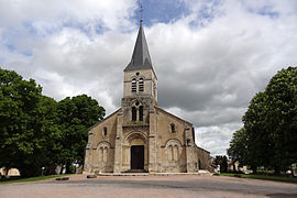 The church in Boucé | |
Location of Boucé  | |
 Boucé  Boucé | |
| Coordinates: 46°19′07″N 3°29′38″E / 46.3186°N 3.4939°E | |
| Country | France |
| Region | Auvergne-Rhône-Alpes |
| Department | Allier |
| Arrondissement | Vichy |
| Canton | Saint-Pourçain-sur-Sioule |
| Government | |
| • Mayor (2020–2026) | Roseline Gourdon[1] |
| Area 1 | 21.68 km2 (8.37 sq mi) |
| Population (2021)[2] | 490 |
| • Density | 23/km2 (59/sq mi) |
| Time zone | UTC+01:00 (CET) |
| • Summer (DST) | UTC+02:00 (CEST) |
| INSEE/Postal code | 03034 /03150 |
| Elevation | 246–310 m (807–1,017 ft) (avg. 265 m or 869 ft) |
| 1 French Land Register data, which excludes lakes, ponds, glaciers > 1 km2 (0.386 sq mi or 247 acres) and river estuaries. | |
Boucé (French pronunciation: [buse] ; Occitan: Bocèc) is a commune in the Allier department in central France.
Population
[edit]| Year | Pop. | ±% p.a. |
|---|---|---|
| 1968 | 650 | — |
| 1975 | 602 | −1.09% |
| 1982 | 575 | −0.65% |
| 1990 | 532 | −0.97% |
| 1999 | 512 | −0.42% |
| 2007 | 551 | +0.92% |
| 2012 | 535 | −0.59% |
| 2017 | 508 | −1.03% |
| Source: INSEE[3] | ||
See also
[edit]- Communes of the Allier department
References
[edit]- ^ "Répertoire national des élus: les maires" (in French). data.gouv.fr, Plateforme ouverte des données publiques françaises. 13 September 2022.
- ^ "Populations légales 2021" (in French). The National Institute of Statistics and Economic Studies. 28 December 2023.
- ^ Population en historique depuis 1968, INSEE
Wikimedia Commons has media related to Boucé.
Communes of the Allier department | |
|---|---|
| |
|
This Allier geographical article is a stub. You can help Wikipedia by expanding it. |
This article is licensed under CC BY-SA 3.0.
Original source: https://en.wikipedia.org/wiki/Boucé, Allier
Status: article is cached
Original source: https://en.wikipedia.org/wiki/Boucé, Allier
Status: article is cached
 EncycloReader
is supported by the
EncycloReader
is supported by the