Categories
California Historical Landmarks in Placer County
 From Wikipedia - Reading time: 13 min
List table of the properties and districts listed as California Historical Landmarks within Placer County, California.
- Note: Click the "Map of all coordinates" link to the right to view a Google map of all properties and districts with latitude and longitude coordinates in the table below.
Listings
[edit]| Image | [1] | Landmark name | Location | City or town | Summary |
|---|---|---|---|---|---|
 |
404 | Auburn | Historic district 38°53′55″N 121°04′28″W / 38.898611°N 121.074444°W | Auburn | |
 |
397 | Dutch Flat | Historic district 39°12′22″N 120°50′16″W / 39.206111°N 120.837778°W | Dutch Flat | |
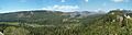 |
403 | Emigrant Gap | Emigrant Gap Vista Pt, Interstate 80 39°18′11″N 120°39′58″W / 39.303°N 120.666°W | Emigrant Gap | |
 |
399 | Foresthill | Historic district 39°01′10″N 120°50′10″W / 39.019444°N 120.836111°W | Foresthill | |
 |
405 | Gold Run | Historic district 39°10′51″N 120°51′21″W / 39.180833°N 120.855833°W | Gold Run | |
 |
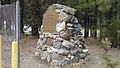
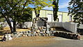
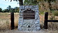
885 | Griffith Quarry | Taylor and Rock Springs Rds. 38°51′04″N 121°09′52″W / 38.851131°N 121.164439°W | Penryn | |
 |
401 | Iowa Hill | Historic district 39°06′31″N 120°51′34″W / 39.108611°N 120.859444°W | Iowa Hill | |
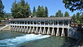 |
797 | Lake Tahoe outlet gates | 73 N Lake Blvd. 39°10′00″N 120°08′36″W / 39.166617°N 120.14345°W | Tahoe City | |
 |
402 | Michigan Bluff | Historic district 39°02′35″N 120°44′29″W / 39.043056°N 120.741389°W | Michigan Bluff | |
 |
463 | Ophir | Historic district 38°53′28″N 121°07′25″W / 38.891111°N 121.123611°W | Ophir | |
Upload Photo |
799 | Overland Emigrant Trail | Big Bend Ranger Station, 2008 Hampshire Rocks Rd. | Soda Springs | |
Upload Photo |
585 | Pioneer Express Trail | Folsom Lake State Recreation Area 38°43′30″N 121°10′19″W / 38.724983°N 121.17205°W | Folsom | |
 |
724 | Pioneer Ski Area of America | Cable Car Building 39°11′48″N 120°14′09″W / 39.196683°N 120.235833°W | Squaw Valley | |
 |
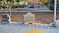
780 | Transcontinental Railroad - Auburn | 639 Lincoln Way 38°54′07″N 121°03′58″W / 38.901867°N 121.066133°W | Auburn | Building now serves as a Chamber of Commerce |
 |
780 | Transcontinental Railroad - Colfax | Grass Valley Street and Railroad Tracks in Railroad Park 39°06′01″N 120°57′10″W / 39.100183°N 120.95265°W | Colfax | |
 |
780 | Transcontinental Railroad - Newcastle | Main and Page Sts 38°52′32″N 121°08′03″W / 38.875617°N 121.134167°W | Newcastle | |
 |
780 | Transcontinental Railroad - Rocklin | Rocklin Rd and First St 38°47′30″N 121°14′16″W / 38.791683°N 121.237883°W | Rocklin | |
 |
780 | Transcontinental Railroad - Roseville | Church St. & Washington Blvd. 38°45′04″N 121°17′10″W / 38.751033°N 121.28615°W | Roseville | |
 |
400 | Virginiatown | 4725 Virginiatown Rd. 38°54′02″N 121°12′53″W / 38.900556°N 121.214722°W | Newcastle | |
 |
398 | Yankee Jims | Colfax Foresthill and Springs Garden Rds. 39°01′46″N 120°51′42″W / 39.029444°N 120.861667°W | Foresthill |
References
[edit]- ^ "California Historical Landmarks By County". Ohp.parks.ca.gov. Retrieved April 3, 2019.
See also
[edit]Wikimedia Commons has media related to California Historical Landmarks in Placer County, California.
- List of California Historical Landmarks
- National Register of Historic Places listings in Placer County, California
This article is licensed under CC BY-SA 3.0.
Original source: https://en.wikipedia.org/wiki/California Historical Landmarks in Placer County
Status: article is cached
Original source: https://en.wikipedia.org/wiki/California Historical Landmarks in Placer County
Status: article is cached
 EncycloReader
is supported by the
EncycloReader
is supported by the