Categories
California Historical Landmarks in San Bernardino County
 From Wikipedia - Reading time: 14 min
List table of the properties and districts — listed on the California Historical Landmarks — within San Bernardino County, Southern California.
- Note: Click the "Map of all coordinates" link to the right to view a Google map of all properties and districts with latitude and longitude coordinates in the table below.
Listings
[edit]| Image | [1] | Landmark name | Location | City or town | Summary |
|---|---|---|---|---|---|
 |
121 | Agua Mansa Cemetery | Agua Mansa Cemetery, 270 E Agua Mansa Rd. 34°02′31″N 117°21′47″W / 34.0419°N 117.3631°W | Colton | |
 |
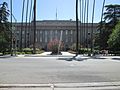
994 | A.K. Smiley Public Library | 125 West Vine St. 34°03′16″N 117°11′03″W / 34.054367°N 117.18405°W | Redlands | Also on the NRHP list as NPS-76000513 |
 |
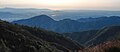
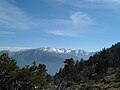
977 | Arrowhead | Wildwood Park 34°10′07″N 117°16′42″W / 34.168645°N 117.278355°W | San Bernardino | |
 |
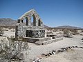
782 | Calico | Ghost Town Road 34°56′56″N 116°51′51″W / 34.948889°N 116.864167°W | Yermo | |
 |
963 | Camp Cady | 24 mi N. of Barstow (take Harvard Rd. offramp from I-15, turn right, go .8 mi. to Cherokee Rd., turn left and go 2.5 mi. and turn right at 2nd fence line. At the end of a dirt road.) 34°56′42″N 116°35′57″W / 34.94505°N 116.599217°W | Newberry Springs | |
 |
985 | Camp Clipper | Desert Training Center 34°48′29″N 115°13′11″W / 34.808167°N 115.21975°W | Fenner | |
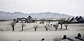 |
985 | Camp Ibis | Desert Training Center 34°58′10″N 114°49′58″W / 34.969517°N 114.83265°W | Needles | |
 |
985 | Camp Iron Mountain | Desert Training Center 34°04′55″N 115°07′47″W / 34.082067°N 115.129767°W | Vidal | |
 |
737 | Chimney Rock | On State Hwy 18 and Rabbit Springs Rd. 34°27′00″N 117°00′14″W / 34.449998°N 117.003922°W | Lucerne Valley | |
 |
490 | Rancho Cucamonga | Cucamonga Winery 8916 Foothill Blvd. 34°06′24″N 117°36′39″W / 34.106683°N 117.6107°W | Rancho Cucamonga | |
 |
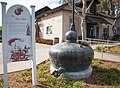
579 | Daley Toll Road Monument | On State Hwy 18 at Daley Canyon Rd 34°13′50″N 117°12′57″W / 34.2305666666667°N 117.215958333333°W | Rimforest | |
 |
617 | Fort Benson | 10600 Hunts Ln. 34°03′41″N 117°17′16″W / 34.06125°N 117.28765°W | Colton | |
 |
892 | Harvey House | 685 North 1st Ave. 34°54′17″N 117°01′29″W / 34.904722°N 117.024722°W | Barstow | Also on the NRHP list as NPS-75000458 |
 |
622 | Harry Wade Exit Route | State Hwy 127 35°37′59″N 116°17′27″W / 35.632917°N 116.290833°W | Baker | |
 |
619 | Holcomb Valley | Big Bear Valley Historical Society Museum 34°18′05″N 116°53′09″W / 34.301417°N 116.88575°W | Big Bear City | |
 |
939 | Hulaville Forest, Folk Art | Amargosa Rd, 2.0 mi W of I-15 and Phelan Rd. 34°55′31″N 116°53′12″W / 34.9252888888889°N 116.886627777778°W | Hesperia | |
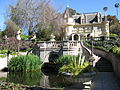 |
1019 | Kimberly Crest | 1325 Prospect Dr 34°02′16″N 117°10′21″W / 34.037836°N 117.172464°W | Redlands | |
 |
1028 | Madonna of the Trail | 1100 Block of North Euclid Ave. 34°06′26″N 117°39′04″W / 34.10725°N 117.651183°W | Upland | |
 |
618 | Garcés-Smith Monument | San Bernardino National Forest 34°14′44″N 117°21′12″W / 34.245533°N 117.353431°W | Colton | |
 |
95 | Guachama Rancheria | 25894 Mission Rd. 34°03′23″N 117°14′17″W / 34.0564388888889°N 117.237922222222°W | Redlands | |
 |
963 | Mojave Road | Midway Rest Area, N-bound I-15 33°47′05″N 118°15′29″W / 33.7846666666667°N 118.258163888889°W | Barstow | |
 |
43 | Mill Creek Zanja | Sylvan Park 34°03′37″N 117°10′04″W / 34.060283°N 117.16765°W | Redlands | Also on the NRHP list as NPS-77000329 |
 |
96 | Mormon Lumber Road | Waterman Canyon | Crestline | |
 |
44 | Mormon Stockade | San Bernardino County Courthouse 34°06′20″N 117°17′21″W / 34.105533°N 117.28915°W | San Bernardino | |
 |
577 | Mormon Trail Monument | W Cajon Canyon, State Hwy 138 34°21′05″N 117°31′37″W / 34.351483°N 117.527017°W | San Bernardino | |
 |
781 | National Old Trail Monument | On shoulder of NW corner of Colorado River Bridge, North K St. 34°51′04″N 114°36′35″W / 34.85101°N 114.609767°W | Needles | |
 |
725 | Old Bear Valley Dam | Big Bear Lake 34°14′31″N 116°58′34″W / 34.2420527777778°N 116.976066666667°W | Big Bear Lake | |
 Folk art |
939 | Possum Trot Folk art |
Ghost Town Rd, 1.5 mi N of I-15 34°55′31″N 116°53′12″W / 34.9252888888889°N 116.886627777778°W | Yermo | |
 |
942 | Rancho Santa Ana del Chino | Chino Fire Station No. 2, 4440 Eucalyptus Ave. 33°59′24″N 117°43′03″W / 33.989937°N 117.717621°W | Chino | |
 |
42 | San Bernardino de Sena Estancia | 26930 Barton Rd. 34°02′40″N 117°13′15″W / 34.044444°N 117.220833°W | Redlands | |
 |
576 | Santa Fe And Salt Lake Trail Monument | Cajon Pass S end Wagon Train Rd, SE corner I-15 and State Hwy 138 34°18′22″N 117°28′00″W / 34.3062°N 117.466622°W | San Bernardino | |
 |
774 | Searles Lake Borax discovery | Trona Rd at Center St 35°45′28″N 117°22′38″W / 35.757683°N 117.377333°W | San Bernardino | |
 |
578 | Stoddard-Waite Monument | Elsie Arey May Nature Center 34°18′13″N 117°28′00″W / 34.303533°N 117.466617°W | San Bernardino | |
 |
573 | Sycamore Grove | Glen Helen Regional Park 34°12′38″N 117°24′23″W / 34.2105°N 117.406263888889°W | Devore | |
 |
360 | Tapia Adobe | Rancho Cucamonga - 8916 Foothill Blvd. 34°06′24″N 117°36′39″W / 34.106667°N 117.61095°W | Rancho Cucamonga | |
 |
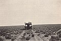
950 | U.S. Rabbit Experimental Station | Josephine Knoph Senior Citizen Center of Fontana, 8384 Cypress Ave 34°06′06″N 117°26′40″W / 34.101567°N 117.444533°W | Fontana | |
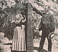 |
859 | Von Schmidt State Boundary Monument | E side of Pew Rd (River Rd), 2.6 mi S of state line 35°00′51″N 114°39′43″W / 35.01425°N 114.661817°W | Needles | |
 |
191 | Yorba-Slaughter Adobe | 17127 Pomona-Rincon Rd. 33°56′25″N 117°39′57″W / 33.940167°N 117.665767°W | Chino | Also on the NRHP list as NPS-75000460 |
 |
528 | Yucaipa Adobe | 32183 Kentucky St. 34°02′31″N 117°21′47″W / 34.0419°N 117.3631°W | Yucaipa | |
|
620 | Yucaipa Rancheria | 32183 Kentucky St. 34°01′21″N 117°06′08″W / 34.022433°N 117.102333°W | Yucaipa |
See also
[edit]Wikimedia Commons has media related to California Historical Landmarks in San Bernardino County, California.
- List of California Historical Landmarks
- National Register of Historic Places listings in San Bernardino County, California
References
[edit]- ^ "California Historical Landmarks By County". Ohp.parks.ca.gov. Retrieved April 3, 2019.
This article is licensed under CC BY-SA 3.0.
Original source: https://en.wikipedia.org/wiki/California Historical Landmarks in San Bernardino County
Status: article is cached
Original source: https://en.wikipedia.org/wiki/California Historical Landmarks in San Bernardino County
Status: article is cached
 EncycloReader
is supported by the
EncycloReader
is supported by the