Cap de la Chèvre
 From Wikipedia - Reading time: 3 min
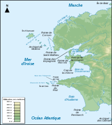

The cap de la Chèvre is the southernmost point of the Crozon peninsula in western Brittany in France. Facing south, it faces the north side of cap Sizun and closes off the baie de Douarnenez.
Consisting of heath, heather and maritime pines, this headland maintains a savage appearance and magnificent countryside, along with several little villages with stone-built houses typical of the region. At the end of the headland, in good weather, one can see cap Sizun, île de sein, the baie de Douarnenez, pointe de Pen-Hir, pointe Saint-Mathieu and the islands of Ushant and Molène.
Sheep will soon be reintroduced into the cap de la Chèvre, to maintain the moors of the Conservatoire du littoral.
External links[edit]
 Media related to Cap de la Chèvre at Wikimedia Commons
| Authority control databases |
|---|
48°10′20″N 4°32′50″W / 48.17222°N 4.54722°W
This Finistère geographical article is a stub. You can help Wikipedia by expanding it. |
Original source: https://en.wikipedia.org/wiki/Cap de la Chèvre
Status: article is cached
 EncycloReader
is supported by the
EncycloReader
is supported by the