Cerro Solo
 From Wikipedia - Reading time: 5 min
| Cerro Solo | |
|---|---|
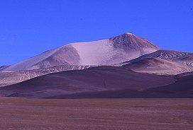 Cerro Solo from the North | |
| Highest point | |
| Elevation | 6,215 m (20,390 ft)[1] |
| Prominence | 715 m (2,346 ft)[2] |
| Parent peak | Nevado Tres Cruces |
| Coordinates | 27°6′19.07″S 068°42′47.52″W / 27.1052972°S 68.7132000°W |
| Geography | |
 Cerro Solo Argentina / Chile | |
| Location | Argentina-Chile |
| Parent range | Andes |
| Geology | |
| Mountain type | Stratovolcano |
| Last eruption | Unknown |
| Climbing | |
| First ascent | 02/21/1950 - Luis Alvarado, Jorge Balastino, Carlos and Oscar Alvarez (Chile)[3][4] |
| Easiest route | Hike |
Cerro Solo is a large stratovolcano on the border between Argentina and Chile, west of Ojos del Salado[5] with an elevation of 6,215 metres (20,390 ft) metres.[6][7][a][b][c] It consists of nine eruptive centers and is covered in light-colored rhyodacite pyroclastic flow deposits.
Its territory is within the Argentinean protection area of Catamarca High Andean and Puna Lakes Ramsar Site.[6] It is located in the territory of the Argentinean province of Catamarca (commune of Fiambalá)[6] and the Chilean province of Copiapo (commune of Copiapó).[7]
First Ascent[edit]
Solo was first climbed by Luis Alvarado, Jorge Balastino, Carlos and Oscar Alvarez (Chile) on 21 February 1950.[3][13]
See also[edit]
- List of volcanoes in Argentina
- List of volcanoes in Chile
Notes[edit]
- ^ Official height of 6205 meters.[8]
- ^ Other data from available digital elevation models: SRTM yields 6200 metres,[9] SRTM 6200 metres,[9] ALOS 6183 metres[10] and TanDEM-X 6241 metres[11]
- ^ The height of the nearest key col is 5500 meters, leading to a topographic prominence of 715 meters.[12] Its parent peak is Tres Cruces Sur and the Topographic isolation is 6.5 kilometers.[2]
External links[edit]
References[edit]
- ^ Biggar, John (2020). The Andes - A Guide for Climbers and Skiers (5th ed.). Scotland: Andes. p. 330. ISBN 978-0-9536087-6-8.
- ^ a b "Solo". Andes Specialists. Retrieved 2020-04-12.
- ^ a b "Ascensión al nevado de El Muerto, la montaña de la incógnita". Centro Cultural Argentino de Montaña. Retrieved 2021-08-18.
- ^ "Tres Quebradas". estiloandino (in Spanish). Retrieved 2021-08-18.
- ^ Biggar, John (2020). The Andes a guide for climbers (5th ed.). Castle Douglas, Scotland. ISBN 978-0-9536087-7-5. OCLC 1260820889.
{{cite book}}: CS1 maint: location missing publisher (link) - ^ a b c "Capas SIG | Instituto Geográfico Nacional". www.ign.gob.ar. Retrieved 2020-04-30.
- ^ "IGM Chile". IGM Chile. 14 April 2020. Retrieved 14 April 2020.
- ^ a b "90 metre SRTM Imagery South_America - Tile: S28W069.hgt.zip". Ardupilot.org Website - SRTM HGT Imagery. 2000. Archived from the original on 2021-08-22. Retrieved 2021-08-18.
- ^ "ALOS GDEM Project - JAXA | Japan Aerospace Exploration Agency EORC (Earth Observation Research Center) Tile: S28W069.zip". www.eorc.jaxa.jp. Data centre requires user registration. 2006. Retrieved 2021-08-18.
{{cite web}}: CS1 maint: others (link)[permanent dead link] - ^ "German Aerospace Center (DLR) TanDEM-X Data - Tile: TDM1_DEM__30_S28W069.zip". DLR - GeoService. Data source requires user registration. 2010. Retrieved 2021-08-18.
{{cite web}}: CS1 maint: others (link) - ^ "IGM Chile". IGM Chile. 8 August 2022. Retrieved 8 August 2022.
- ^ Almaraz, Guillermo. "Tres Quebradas". estiloandino (in Spanish). Archived from the original on 2020-09-28. Retrieved 2021-08-18.
- "El Solo". Global Volcanism Program. Smithsonian Institution.
This article about a place in Catamarca Province, Argentina is a stub. You can help Wikipedia by expanding it. |
This Atacama Region location article is a stub. You can help Wikipedia by expanding it. |
This article related to a mountain, mountain range, or peak in Argentina is a stub. You can help Wikipedia by expanding it. |
This article related to a mountain, mountain range, or peak in Chile is a stub. You can help Wikipedia by expanding it. |
Original source: https://en.wikipedia.org/wiki/Cerro Solo
Status: article is cached
 EncycloReader
is supported by the
EncycloReader
is supported by the