Chambles
 From Wikipedia - Reading time: 8 min
Chambles | |
|---|---|
Commune | |
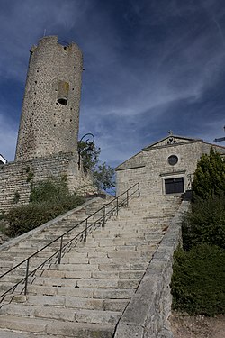 Tower and staircase | |
 Coat of arms | |
Location of Chambles  | |
 Chambles  Chambles | |
| Coordinates: 45°26′34″N 4°14′20″E / 45.4428°N 4.2389°E | |
| Country | France |
| Region | Auvergne-Rhône-Alpes |
| Department | Loire |
| Arrondissement | Montbrison |
| Canton | Saint-Just-Saint-Rambert |
| Intercommunality | CA Loire Forez |
| Government | |
| • Mayor (2020–2026) | Pierre Giraud[1] |
Area 1 | 18.9 km2 (7.3 sq mi) |
| Population (2022)[2] | 1,071 |
| • Density | 57/km2 (150/sq mi) |
| Time zone | UTC+01:00 (CET) |
| • Summer (DST) | UTC+02:00 (CEST) |
| INSEE/Postal code | 42042 /42170 |
| Elevation | 360–741 m (1,181–2,431 ft) (avg. 640 m or 2,100 ft) |
| 1 French Land Register data, which excludes lakes, ponds, glaciers > 1 km2 (0.386 sq mi or 247 acres) and river estuaries. | |
Chambles (French pronunciation: [ʃɑ̃bl]) is a commune in the Loire department in central France. The commune has an area of 18.90 km2 and its altitude ranges from 360 to 741 meters.[3] As of 2019, there were 522 dwellings in Chambles, of which 420 main residences.[4]
Population
[edit]
|
| ||||||||||||||||||||||||||||||||||||||||||||||||||||||||||||||||||||||||||||||||||||||||||||||||||||||||||||||||||
| Source: EHESS[3] and INSEE (1968-2017)[5] | |||||||||||||||||||||||||||||||||||||||||||||||||||||||||||||||||||||||||||||||||||||||||||||||||||||||||||||||||||
See also
[edit]- Communes of the Loire department
References
[edit]- ^ "Répertoire national des élus: les maires". data.gouv.fr, Plateforme ouverte des données publiques françaises (in French). 2 December 2020.
- ^ "Populations de référence 2022" (in French). The National Institute of Statistics and Economic Studies. 19 December 2024.
- ^ a b Des villages de Cassini aux communes d'aujourd'hui: Commune data sheet Chambles, EHESS (in French).
- ^ Logement en 2019, INSEE
- ^ Population en historique depuis 1968, INSEE
Wikimedia Commons has media related to Chambles.
Communes of the Loire department | |
|---|---|
| |
|
This Loire geographical article is a stub. You can help Wikipedia by expanding it. |
This article is licensed under CC BY-SA 3.0.
Original source: https://en.wikipedia.org/wiki/Chambles
Status: article is cached
Original source: https://en.wikipedia.org/wiki/Chambles
Status: article is cached
 EncycloReader
is supported by the
EncycloReader
is supported by the