Table of Contents Categories
Cranendonck
 From Wikipedia - Reading time: 5 min
Cranendonck | |
|---|---|
Municipality | |
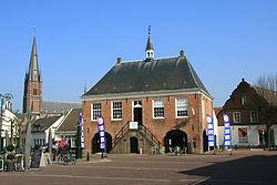 Former city hall of Budel | |
 Flag  Coat of arms | |
 Location in North Brabant | |
| Coordinates: 51°18′N 5°35′E / 51.300°N 5.583°ECoordinates: 51°18′N 5°35′E / 51.300°N 5.583°E | |
| Country | Netherlands |
| Province | North Brabant |
| Established | 1 January 1997[1] |
| Government | |
| • Body | Municipal council |
| • Mayor | Roland van Kessel (VVD) |
| Area | |
| • Total | 78.05 km2 (30.14 sq mi) |
| • Land | 76.40 km2 (29.50 sq mi) |
| • Water | 1.65 km2 (0.64 sq mi) |
| Elevation | 28 m (92 ft) |
| Population (January 2019)[4] | |
| • Total | 20,440 |
| • Density | 268/km2 (690/sq mi) |
| Time zone | UTC+1 (CET) |
| • Summer (DST) | UTC+2 (CEST) |
| Postcode | 6020–6028 |
| Area code | 0495 |
| Website | www |
Cranendonck (pronounced [ˈkraːnə(n)dɔŋk] (![]() listen)) is a municipality in the southern Netherlands.
Though located in North Brabant near Eindhoven, the spoken dialect is Budels (linguistically a West Limburgish dialect), rather than Kempenlands (linguistically an East Brabantian dialect).
listen)) is a municipality in the southern Netherlands.
Though located in North Brabant near Eindhoven, the spoken dialect is Budels (linguistically a West Limburgish dialect), rather than Kempenlands (linguistically an East Brabantian dialect).
Population centres[edit]
- Budel
- Budel-Dorplein
- Budel-Schoot
- Gastel
- Heikant, Gastel
- Maarheeze
- Soerendonk
Topography[edit]

Dutch topographic map of the municipality of Cranendonck, June 2015
Notable people[edit]

Sylvia Hoeks, 2017
- Antonius Mathijsen (1805 in Budel – 1878) a Dutch army surgeon who first used plaster of Paris
- Hans Teeuwen (born 1967 in Budel) a Dutch comedian, musician, actor and occasional filmmaker[5]
- Sylvia Hoeks (born 1983 in Maarheeze) a Dutch actress and former model[6]
Sport[edit]
- Toine van Mierlo (born 1957 in Soerendonk) a retired Dutch footballer with 230 club caps
- Craig Osaikhwuwuomwan (born 1990 in Budel) a Dutch professional basketball player
- Yvon Beliën (born 1993 in Budel) is a Dutch volleyball player, helped the Netherlands reach their first Olympic semifinals at the 2016 Summer Olympics
Gallery[edit]
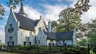
Achterzijde van 'Kasteel' Cranendonck te Soerendonk
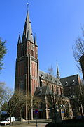
Budel - Kerkstraat, Vrouw Visitatie kerk

Maarheeze - Kerkstraat - Woonhuis

Zinkfabriek Budel
References[edit]
- ^ "Gemeentelijke indeling op 1 januari 1997" [Municipal divisions on 1 January 1997]. cbs.nl (in Dutch). CBS. Retrieved 8 May 2014.
- ^ "Kerncijfers wijken en buurten 2020" [Key figures for neighbourhoods 2020]. StatLine (in Dutch). CBS. 24 July 2020. Retrieved 19 September 2020.
- ^ "Postcodetool for 6027RK". Actueel Hoogtebestand Nederland (in Dutch). Het Waterschapshuis. Retrieved 8 May 2014.
- ^ "Bevolkingsontwikkeling; regio per maand" [Population growth; regions per month]. CBS Statline (in Dutch). CBS. 1 January 2019. Retrieved 1 January 2019.
- ^ IMDb Database retrieved 13 October 2019
- ^ IMDb Database retrieved 13 October 2019
External links[edit]
 Media related to Cranendonck at Wikimedia Commons
- Official website
Places adjacent to Cranendonck | ||||||||||||||||
|---|---|---|---|---|---|---|---|---|---|---|---|---|---|---|---|---|
| ||||||||||||||||
Municipalities of North Brabant | ||
|---|---|---|
|  | |
| ||
| Authority control |
|
|---|
This North Brabant location article is a stub. You can help Wikipedia by expanding it. |
This article is licensed under CC BY-SA 3.0.
Original source: https://en.wikipedia.org/wiki/Cranendonck
Status: article is cached
Original source: https://en.wikipedia.org/wiki/Cranendonck
Status: article is cached
 EncycloReader
is supported by the
EncycloReader
is supported by the