Easternijtsjerk
 From Wikipedia - Reading time: 6 min
Easternijtsjerk | |
|---|---|
Village | |
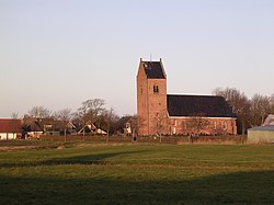 St Cecile's church | |
 Flag  Coat of arms | |
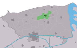 Location in the former Dongeradeel municipality | |
 Easternijtsjerk Location in the Netherlands  Easternijtsjerk Easternijtsjerk (Netherlands) | |
| Coordinates: 53°22′43″N 6°3′13″E / 53.37861°N 6.05361°E | |
| Country | |
| Province | |
| Municipality | Noardeast-Fryslân |
| Area | |
| • Total | 6.68 km2 (2.58 sq mi) |
| Elevation | 0.5 m (1.6 ft) |
| Population (2021)[1] | |
| • Total | 940 |
| • Density | 140/km2 (360/sq mi) |
| Postal code | 9137[1] |
| Dialing code | 0519 |
Easternijtsjerk (Dutch: Oosternijkerk) is a village in Noardeast-Fryslân in the province of Friesland, the Netherlands. It had a population of around 944 in January 2017.[3] Before 2019, the village was part of the Dongeradeel municipality.[4]
History[edit]
The village was first mentioned in 1224 as Nova Ecclesia, and means the new eastern church to differentiate from Westernijtsjerk.[5] Easternijtsjerk appeared after a dyke was built in the 11th or 12th century. The Dutch Reformed church received its current shape in the 15th century and has a 13th century tower.[6] In 1840, Easternijtsjerk was home to 695 people.[4]
The village's official name was changed from Oosternijkerk to Easternijtsjerk in 2023.[7][8]
References[edit]
- ^ a b c "Kerncijfers wijken en buurten 2021". Central Bureau of Statistics. Retrieved 1 April 2022.
two entries
- ^ "Postcodetool for 9137CD". Actueel Hoogtebestand Nederland (in Dutch). Het Waterschapshuis. Retrieved 1 April 2022.
- ^ Aantal inwoners per woonplaats in Dongeradeel op 1 januari 2017 Archived 2017-10-21 at the Wayback Machine - Dongeradeel
- ^ a b "Oosternijkerk". Plaatsengids (in Dutch). Retrieved 1 April 2022.
- ^ "Oosternijkerk - (geografische naam)". Etymologiebank (in Dutch). Retrieved 1 April 2022.
- ^ Ronald Stenvert & Sabine Broekhoven (2000). "Oosternijkerk" (in Dutch). Zwolle: Waanders. ISBN 90 400 9476 4. Retrieved 1 April 2022.
- ^ "22 dorpen in Noardeast-Fryslân krijgen op 1 januari 2023 een nieuwe Friese naam" [22 villages in Noardeast-Fryslân will receive a new Frisian name on 1 January 2023]. RTV NOF (in Dutch). 10 December 2022. Retrieved 7 April 2023.
- ^ "Friese namen" [Frisian names]. Taalunie (in Dutch). Retrieved 7 April 2023.
External links[edit]
![]() Media related to Easternijtsjerk at Wikimedia Commons
Media related to Easternijtsjerk at Wikimedia Commons
This Friesland location article is a stub. You can help Wikipedia by expanding it. |
Original source: https://en.wikipedia.org/wiki/Easternijtsjerk
Status: article is cached
 EncycloReader
is supported by the
EncycloReader
is supported by the