Herlies
 From Wikipedia - Reading time: 10 min
Herlies | |
|---|---|
Commune | |
 The town hall in Herlies | |
 Coat of arms | |
Location of Herlies  | |
 Herlies  Herlies | |
| Coordinates: 50°34′44″N 2°51′18″E / 50.5789°N 2.855°E | |
| Country | France |
| Region | Hauts-de-France |
| Department | Nord |
| Arrondissement | Lille |
| Canton | Annœullin |
| Intercommunality | Métropole Européenne de Lille |
| Government | |
| • Mayor (2020–2026) | Bernard Debeer[1] |
Area 1 | 7.11 km2 (2.75 sq mi) |
| Population (2022)[2] | 2,288 |
| • Density | 320/km2 (830/sq mi) |
| Time zone | UTC+01:00 (CET) |
| • Summer (DST) | UTC+02:00 (CEST) |
| INSEE/Postal code | 59303 /59134 |
| Elevation | 24–41 m (79–135 ft) (avg. 37 m or 121 ft) |
| 1 French Land Register data, which excludes lakes, ponds, glaciers > 1 km2 (0.386 sq mi or 247 acres) and river estuaries. | |
Herlies (French pronunciation: [ɛʁli]) is a commune in the Nord department in northern France. It is part of the Métropole Européenne de Lille.[3]
Population
[edit]| Year | Pop. | ±% p.a. |
|---|---|---|
| 1968 | 805 | — |
| 1975 | 814 | +0.16% |
| 1982 | 1,236 | +6.15% |
| 1990 | 1,697 | +4.04% |
| 1999 | 2,015 | +1.93% |
| 2007 | 2,059 | +0.27% |
| 2012 | 2,225 | +1.56% |
| 2017 | 2,399 | +1.52% |
| Source: INSEE[4] | ||
Heraldry
[edit] |
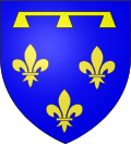
The arms of Herlies are blazoned : Azure, 3 fleurs de lys, in chief a label of three points Or.
|
See also
[edit]- Communes of the Nord department
References
[edit]- ^ "Répertoire national des élus: les maires" (in French). data.gouv.fr, Plateforme ouverte des données publiques françaises. 13 September 2022.
- ^ "Populations de référence 2022" (in French). The National Institute of Statistics and Economic Studies. 19 December 2024.
- ^ INSEE commune file
- ^ Population en historique depuis 1968, INSEE
Wikimedia Commons has media related to Herlies.
Communes of the Métropole Européenne de Lille | ||
|---|---|---|
| ||
Communes of the Nord department | |
|---|---|
| |
|
This Arrondissement of Lille geographical article is a stub. You can help Wikipedia by expanding it. |
This article is licensed under CC BY-SA 3.0.
Original source: https://en.wikipedia.org/wiki/Herlies
Status: article is cached
Original source: https://en.wikipedia.org/wiki/Herlies
Status: article is cached
 EncycloReader
is supported by the
EncycloReader
is supported by the