Kuala Muda District
 From Wikipedia - Reading time: 12 min
This article needs additional citations for verification. (January 2017) |
Kuala Muda District | |
|---|---|
| Daerah Kuala Muda | |
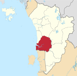 Location of Kuala Muda District in Kedah | |
 | |
 Kuala Muda District Location of Kuala Muda District in Malaysia | |
| Coordinates: 5°40′N 100°30′E / 5.667°N 100.500°E | |
| Country | |
| State | |
| Seat | Sungai Petani |
| Local area government(s) | Sungai Petani Municipal Council |
| Government | |
| • District officer | Md Shuhaime Abdul Rahman |
| Area | |
• Total | 928.35 km2 (358.44 sq mi) |
| Population (2020[2]) | |
• Total | 521,200 |
| • Density | 560/km2 (1,500/sq mi) |
| Time zone | UTC+8 (MST) |
| • Summer (DST) | UTC+8 (Not observed) |
| Postcode | 09xxx |
| Calling code | +6-044 |
| Vehicle registration plates | K |
The Kuala Muda District is a district in Kedah, Malaysia. Sungai Petani is the administrative center of the district. Kuala Muda district is in close proximity to the border of Kedah and Penang. Apart from Sungai Petani, other major towns in the district include Tikam Batu, Padang Tembusu, Sungai Lalang, Bedong, Bukit Selambau, Sidam, Gurun, Semeling, Merbok, Kota Kuala Muda and Tanjung Dawai. The Mount Jerai is shared with the neighbouring district of Yan while the Muda River is shares the bordering state of Penang. The iconic Jambatan Merdeka (Independent Bridge) connect both Tikam Batu with Bumbung Lima in Penang. Kuala Muda is the second largest and most populous district in Kedah, and it is also the site of some of the earliest civilization site in the country.
History
[edit]The name Kuala Muda may derived from the river that cut cross the southern part of Kedah, Sungai Muda (Muda River) which meets the Strait of Melaka in the fishing village of Kampung Sungai Muda, Kota Kuala Muda. Confluences of the river were also part of the Kedah history; Sungai Merbok and Sungai Mas harboured among the earliest civilization in the country, Sungai Sungai Petani, Sungai Semeling and Sungai Ketil. Ancient ruins and artifacts can be found across the districts, from temple-like structures or candis, the Kota Kuala Muda Gates, ancient boats called Perahu Sagor, glass beads, Buddhist and Hindu statues and potteries.
The district suffered from the 2004 tsunami which caused 11 casualties.[3]

Administrative divisions
[edit]Kuala Muda District is divided into 16 mukims, which are:[4]
- Bujang
- Bukit Meriam
- Gurun
- Haji Kudong
- Kota
- Kuala
- Merbok
- Pekula
- Pinang Tunggal
- Rantau Panjang
- Semeling
- Sidam Kiri
- Simpor
- Sungai Pasir
- Sungai Petani
- Teloi Kiri
Demographics
[edit]| Year | Pop. | ±% | ||
|---|---|---|---|---|
| 1991 | 254,372 | — | ||
| 2000 | 339,898 | +33.6% | ||
| 2010 | 443,488 | +30.5% | ||
| 2020 | 544,984 | +22.9% | ||
| ||||
| Source: [5] | ||||
Federal Parliament and State Assembly Seats
[edit]
List of Kuala Muda district representatives in the Federal Parliament (Dewan Rakyat)
| Parliament | Seat Name | Member of Parliament | Party |
|---|---|---|---|
| P12 | Jerai | Sabri bin Azit | Perikatan Nasional (PAS) |
| P14 | Merbok | Mohd Nazri Abu Hassan | Perikatan Nasional (BERSATU) |
| P15 | Sungai Petani | Mohammed Taufiq Johari | Pakatan Harapan (PKR) |
List of Kuala Muda district representatives in the State Legislative Assembly (Dewan Undangan Negeri)
| Parliament | State | Seat Name | State Assemblyman | Party |
|---|---|---|---|---|
| P12 | N22 | Gurun | Baddrol Bakhtiar | Perikatan Nasional (PAS) |
| P14 | N25 | Bukit Selambau | Azizan Hamzah | Perikatan Nasional (PAS) |
| P14 | N26 | Tanjung Dawai | Hanif Bin Ghazali | Perikatan Nasional (PAS) |
| P15 | N27 | Pantai Merdeka | Shahrir Long | Perikatan Nasional (PAS) |
| P15 | N28 | Bakar Arang | Adam Loh Wei Chai | Pakatan Harapan (PKR) |
| P15 | N29 | Sidam | Bau Wong Bau Ek | Pakatan Harapan (PKR) |
See also
[edit]- Districts of Malaysia
References
[edit]- ^ "Laman Web Rasmi Pejabat Daerah Kuala Muda - Sejarah Pentadbiran". pdkm.kedah.gov.my. Archived from the original on 2017-12-07. Retrieved 2017-11-26.
- ^ "Kependudukan Negeri Kedah" (PDF). Department of Statistics Malaysia. Retrieved 4 June 2023.
- ^ "Sembilan tahun menanti pembukaan Galeri Tsunami di Kota Kuala Muda" (in Malay). Utusan Online. 26 December 2015. Retrieved 2 March 2018.
- ^ "PEJABAT DAERAH KUALA MUDA". pejabatdaerahkualamuda.blogspot.my. 28 February 2011.
- ^ "Key Findings of Population and Housing Census of Malaysia 2020" (pdf) (in Malay and English). Department of Statistics, Malaysia. ISBN 978-967-2000-85-3.
State of Kedah | |||||||
|---|---|---|---|---|---|---|---|
Capital: Alor Setar, Royal town: Anak Bukit | |||||||
| Topics |
| ||||||
| Society |
| ||||||
| Administrative divisions |
| ||||||
| |||||||
Authority control databases | |
|---|---|
| International | |
| National | |
Original source: https://en.wikipedia.org/wiki/Kuala Muda District
Status: article is cached
 EncycloReader
is supported by the
EncycloReader
is supported by the