Moissy-Cramayel
 From Wikipedia - Reading time: 10 min
This article needs additional citations for verification. (July 2008) |
Moissy-Cramayel | |
|---|---|
Commune | |
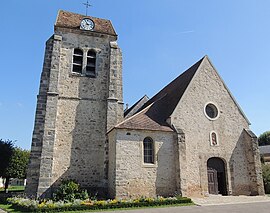 The church in Moissy | |
 Coat of arms | |
 Location (in red) within Paris inner and outer suburbs | |
Location of Moissy-Cramayel  | |
 Moissy-Cramayel  Moissy-Cramayel | |
| Coordinates: 48°37′37″N 2°35′35″E / 48.6269°N 2.5931°E | |
| Country | France |
| Region | Île-de-France |
| Department | Seine-et-Marne |
| Arrondissement | Melun |
| Canton | Combs-la-Ville |
| Intercommunality | CA Grand Paris Sud Seine-Essonne-Sénart |
| Government | |
| • Mayor (2020–2026) | Line Magne[1] |
| Area 1 | 14.28 km2 (5.51 sq mi) |
| Population (2021)[2] | 18,248 |
| • Density | 1,300/km2 (3,300/sq mi) |
| Time zone | UTC+01:00 (CET) |
| • Summer (DST) | UTC+02:00 (CEST) |
| INSEE/Postal code | 77296 /77550 |
| Elevation | 83–94 m (272–308 ft) |
| 1 French Land Register data, which excludes lakes, ponds, glaciers > 1 km2 (0.386 sq mi or 247 acres) and river estuaries. | |
Moissy-Cramayel (French pronunciation: [mwasi kʁamajɛl] ) is a commune in the Seine-et-Marne department in the Île-de-France region in north-central France.[3] It is part of the urban unit (agglomeration) of Paris,[3] 33 km (21 mi) southeast of the center of Paris, in the "new town" of Sénart, created in the 1970s.
Its inhabitants are called Moisséens.
History[edit]
During the French Revolution, Moissy-Cramayel was temporarily renamed Moissy-la-Plaine, meaning "Moissy the Plain".
Population[edit]
Graphs are unavailable due to technical issues. There is more info on Phabricator and on MediaWiki.org. |
| Year | Pop. | ±% p.a. |
|---|---|---|
| 1968 | 2,364 | — |
| 1975 | 3,172 | +4.29% |
| 1982 | 5,195 | +7.30% |
| 1990 | 12,263 | +11.33% |
| 1999 | 14,298 | +1.72% |
| 2007 | 16,932 | +2.14% |
| 2012 | 17,452 | +0.61% |
| 2017 | 17,713 | +0.30% |
| Source: INSEE[4] | ||
Transportation[edit]
Moissy-Cramayel is served by Lieusaint – Moissy station on Paris RER line ![]() .
.
Town twinning[edit]
Moissy-Cramayel is twinned with:
- Rosenfeld, Germany - since 1971
- Rosso, Mauritania - since 1986
- Bușteni, Romania - since 1993
See also[edit]
- Communes of the Seine-et-Marne department
- Moissy Cramayel US, a football club based in Moissy-Cramayel
References[edit]
- ^ "Répertoire national des élus: les maires" (in French). data.gouv.fr, Plateforme ouverte des données publiques françaises. 13 September 2022.
- ^ "Populations légales 2021" (in French). The National Institute of Statistics and Economic Studies. 28 December 2023.
- ^ a b Commune de Moissy-Cramayel (77296), INSEE
- ^ Population en historique depuis 1968, INSEE
External links[edit]
Wikimedia Commons has media related to Moissy-Cramayel.
- Official website (in French)
- 1999 Land Use, from IAURIF (Institute for Urban Planning and Development of the Paris-Île-de-France région) (in English)
- Base Mérimée: Search for heritage in the commune, Ministère français de la Culture. (in French)
| Population over 2 million |
|
|---|---|
| Population over 100,000 |
|
| Population over 75,000 |
|
| Population over 50,000 |
|
| Population over 25,000 |
|
| Population under 25,000 |
|
| |
|
This article related to a Seine-et-Marne location is a stub. You can help Wikipedia by expanding it. |
This article is licensed under CC BY-SA 3.0.
Original source: https://en.wikipedia.org/wiki/Moissy-Cramayel
Status: article is cached
Original source: https://en.wikipedia.org/wiki/Moissy-Cramayel
Status: article is cached
 EncycloReader
is supported by the
EncycloReader
is supported by the