Categories
Murat, Allier
 From Wikipedia - Reading time: 8 min
You can help expand this article with text translated from the corresponding article in French. (December 2008) Click [show] for important translation instructions.
|
Murat | |
|---|---|
Commune | |
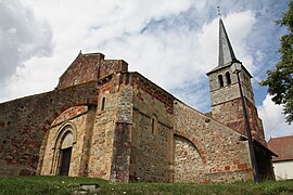 The church in Murat | |
Location of Murat  | |
 Murat  Murat | |
| Coordinates: 46°24′12″N 2°54′42″E / 46.4033°N 2.9117°E | |
| Country | France |
| Region | Auvergne-Rhône-Alpes |
| Department | Allier |
| Arrondissement | Montluçon |
| Canton | Commentry |
| Government | |
| • Mayor (2020–2026) | Ghislaine Bureau[1] |
| Area 1 | 20.07 km2 (7.75 sq mi) |
| Population (Jan. 2021)[2] | 271 |
| • Density | 14/km2 (35/sq mi) |
| Time zone | UTC+01:00 (CET) |
| • Summer (DST) | UTC+02:00 (CEST) |
| INSEE/Postal code | 03191 /03390 |
| Elevation | 247–360 m (810–1,181 ft) (avg. 314 m or 1,030 ft) |
| 1 French Land Register data, which excludes lakes, ponds, glaciers > 1 km2 (0.386 sq mi or 247 acres) and river estuaries. | |
Murat (French pronunciation: [myʁa]) is a commune in the Allier department in central France.
Population[edit]
| Year | Pop. | ±% |
|---|---|---|
| 1962 | 370 | — |
| 1968 | 409 | +10.5% |
| 1975 | 334 | −18.3% |
| 1982 | 295 | −11.7% |
| 1990 | 301 | +2.0% |
| 1999 | 311 | +3.3% |
| 2008 | 280 | −10.0% |
| 2012 | 288 | +2.9% |
| Source: INSEE (1968–2012) | ||
See also[edit]
- Communes of the Allier department
References[edit]
- ^ "Répertoire national des élus: les maires" (in French). data.gouv.fr, Plateforme ouverte des données publiques françaises. 4 May 2022.
- ^ "Populations légales 2021". The National Institute of Statistics and Economic Studies. 28 December 2023.
Wikimedia Commons has media related to Murat, Allier.
Communes of the Allier department | |
|---|---|
| |
|
This Allier geographical article is a stub. You can help Wikipedia by expanding it. |
This article is licensed under CC BY-SA 3.0.
Original source: https://en.wikipedia.org/wiki/Murat, Allier
Status: article is cached
Original source: https://en.wikipedia.org/wiki/Murat, Allier
Status: article is cached
 EncycloReader
is supported by the
EncycloReader
is supported by the