Table of Contents Categories
Outline of Eritrea
 From Wikipedia - Reading time: 9 min


Eritrea is a country in the Horn of Africa. Eritrea is the Italian form of the Greek name Ἐρυθραίᾱ (Erythraíā), meaning "red [land]". With its capital at Asmara, it is bordered by Sudan in the west, Ethiopia in the south, and Djibouti in the southeast. The northeastern and eastern parts of Eritrea have an extensive coastline along the Red Sea, directly across from Saudi Arabia and Yemen. The nation has a total area of approximately 117,600 km2 (45,406 sq mi), and includes the Dahlak Archipelago and several of the Hanish Islands.
Eritrea is a multi-ethnic country, with nine recognized ethnic groups. It has a population of around six million inhabitants. Most residents speak Afro-Asiatic languages, either of the Semitic or Cushitic branches. Among these communities, the Biher-Tigrinya make up about 55% of the population, with the Tigre constituting around 30% of inhabitants. In addition, there are a number of Nilo-Saharan-speaking Nilotic ethnic minorities. Most people in the territory adhere to Christianity or Islam.[1]
General reference
[edit]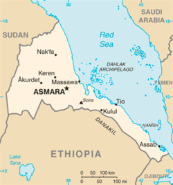
- Pronunciation: /ɛrɪˈtriːə/ or /ɛrɪˈtreɪ.ə/
- Common English country name: Eritrea
- Official English country name: The State of Eritrea
- Common endonym(s):
- Official endonym(s):
- Adjectival(s): Eritrean
- Demonym(s):
- ISO country codes: ER, ERI, 232
- ISO region codes: See ISO 3166-2:ER
- Internet country code top-level domain: .er
Geography of Eritrea
[edit]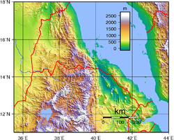
Geography of Eritrea
- Eritrea is: a country
- Location:
- Eastern Hemisphere and Northern Hemisphere
- Africa
- North Africa
- East Africa
- Horn of Africa
- Time zone: East Africa Time (UTC+03)
- Extreme points of Eritrea
- High: Emba Soira 3,018 m (9,902 ft)
- Low: Lake Kulul −75 m (−246 ft)
- Land boundaries: 1,626 km
 Ethiopia 912 km
 Sudan 605 km
 Djibouti 109 km
- Coastline: Red Sea 2,234 km
- Population of Eritrea: 6,333,000 (July 2013 UN estimate) 107th most populous country
- Area of Eritrea: 117,600 km2
- Atlas of Eritrea
Environment of Eritrea
[edit]
Environment of Eritrea
- Climate of Eritrea
- Environmental issues in Eritrea
- Ecoregions in Eritrea
- Geology of Eritrea
- Earthquakes in Eritrea
- Protected areas of Eritrea
- National parks of Eritrea
- Wildlife of Eritrea
- Fauna of Eritrea
- Birds of Eritrea
- Mammals of Eritrea
- Fauna of Eritrea
Natural geographic features of Eritrea
[edit]- Glaciers in Eritrea: none [2]
- Islands of Eritrea
- Mountains of Eritrea
- Volcanoes in Eritrea
- Rivers of Eritrea
- World Heritage Sites in Eritrea: None
Regions of Eritrea
[edit]Ecoregions of Eritrea
[edit]List of ecoregions in Eritrea
Administrative divisions of Eritrea
[edit]Administrative divisions of Eritrea
- Regions of Eritrea
- Districts of Eritrea
Regions of Eritrea
[edit]Regions of Eritrea
Districts of Eritrea
[edit]Districts of Eritrea
Municipalities of Eritrea
[edit]- Capital of Eritrea: Asmara
- Cities of Eritrea
Demography of Eritrea
[edit]Demographics of Eritrea
Government and politics of Eritrea
[edit]Politics of Eritrea
- Form of government: presidential republic
- Capital of Eritrea: Asmara
- Elections in Eritrea
- Political parties in Eritrea
Branches of the government of Eritrea
[edit]Government of Eritrea
Executive branch of the government of Eritrea
[edit]- Head of state: President of Eritrea,
- Head of government: Prime Minister of Eritrea,
Legislative branch of the government of Eritrea
[edit]- Parliament of Eritrea (bicameral)
- Upper house: Senate of Eritrea
- Lower house: House of Commons of Eritrea
Judicial branch of the government of Eritrea
[edit]Court system of Eritrea
Foreign relations of Eritrea
[edit]Foreign relations of Eritrea
- Diplomatic missions in Eritrea
- Diplomatic missions of Eritrea
International organization membership
[edit]The State of Eritrea is a member of:[1]
|
|
Law and order in Eritrea
[edit]Law of Eritrea
- Constitution of Eritrea
- Human rights in Eritrea
- LGBT rights in Eritrea
- Freedom of religion in Eritrea
- Law enforcement in Eritrea
Military of Eritrea
[edit]Military of Eritrea
- Command
- Commander-in-chief
- Forces
- Army of Eritrea
- Navy of Eritrea
- Air Force of Eritrea
Local government in Eritrea
[edit]Local government in Eritrea
History of Eritrea
[edit]
History of Eritrea
- Current events of Eritrea
- Italian Eritrea
- Eritrea Governorate
Culture of Eritrea
[edit]Culture of Eritrea
- Cuisine of Eritrea
- Italian eritrean cuisine
- Languages of Eritrea
- Media in Eritrea
- Museums in Eritrea
- National symbols of Eritrea
- Coat of arms of Eritrea
- Flag of Eritrea
- National anthem of Eritrea
- People of Eritrea
- Prostitution in Eritrea
- Public holidays in Eritrea
- Religion in Eritrea
- Christianity in Eritrea
- Catholicism in Eritrea
- Hinduism in Eritrea
- Islam in Eritrea
- Judaism in Eritrea
- Sikhism in Eritrea
- World Heritage Sites in Eritrea: None
Art in Eritrea
[edit]- Literature of Eritrea
- Music of Eritrea
Sports in Eritrea
[edit]Sports in Eritrea
- Football in Eritrea
- Eritrea at the Olympics
- Tour of Eritrea
Economy and infrastructure of Eritrea
[edit]Economy of Eritrea
- Economic rank, by nominal GDP (2007): 161st (one hundred and sixty first)
- Agriculture in Eritrea
- Banking in Eritrea
- National Bank of Eritrea
- Communications in Eritrea
- Internet in Eritrea
- Companies of Eritrea
- Currency of Eritrea: Nakfa
- ISO 4217: ERN
- Energy in Eritrea
- Mining in Eritrea
- Tourism in Eritrea
- Transport in Eritrea
- Health care in Eritrea
- Transportation in Eritrea
- Airports in Eritrea
- Rail transport in Eritrea
Education in Eritrea
[edit]- Education in Eritrea
Health in Eritrea
[edit]- Health in Eritrea
- COVID-19 pandemic in Eritrea
- COVID-19 vaccination in Eritrea
See also
[edit]- Eritrea
- All pages with titles beginning with Eritrea
- All pages with titles containing Eritrea
- All pages with titles beginning with Eritrean
- All pages with titles containing Eritrean
- List of Eritrea-related topics
- List of international rankings
- Member state of the United Nations
- Outline of Africa
- Outline of geography
References
[edit]- ^ a b Eritrea. The World Factbook. Central Intelligence Agency.
- ^ The only glaciers in Africa are on Mt Kenya (in Kenya), on Kilimanjaro (in Tanzania), and in the Ruwenzori Mountains (which are located in Uganda and the Democratic Republic of the Congo). See Proceedings of the Riederalp Workshop, September 1978; Actes de l'Atelier de Riederalp, septembre 1978): IAHS-AISH Publ. no. 126, 1980.
External links
[edit]- Government
- Official website of the Ministry of Information of Eritrea
- Official website of the Ministry of Education of Eritrea
- Other
- Tigrinya online learning with numbers, alphabet and history [Eritrea and north Ethiopia (Tigray-Province)]
- Eritrea About Eritrea
- CIA World Factbook - Eritrea
- History of Eritrea: First recordings - Munzinger - exploitation by colonialism and fight against colonialism (Italy, England, Ethiopia, Soviet Union, USA, Israel) - independence Archived 2007-10-12 at the Wayback Machine
- The Carter Center information on Eritrea (chronology)
Original source: https://en.wikipedia.org/wiki/Outline of Eritrea
Status: article is cached
 EncycloReader
is supported by the
EncycloReader
is supported by the