Sirajganj District
 From Wikipedia - Reading time: 13 min
Sirajganj District
সিরাজগঞ্জ জেলা | |
|---|---|
District of Bangladesh | |
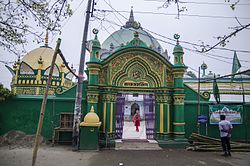      Clockwise from top-left: Shahzadpur Dargah Mosque, Jamuna Bridge, Hard Point, Jamuna Eco Park, Chalan Beel, China Barrage | |
| Nickname: The Gateway to North Bengal | |
 Location of Sirajganj District in Bangladesh | |
 Expandable map of Sirajganj District | |
| Coordinates: 24°20′N 89°37′E / 24.33°N 89.62°E | |
| Country | |
| Division | Rajshahi Division |
| Government | |
| • Deputy Commissioner | Dr. Farook Ahmed |
| Area | |
• Total | 2,402.02 km2 (927.43 sq mi) |
| Flood plain and Marsh land | |
| Elevation | 7 m (23 ft) |
| Population (2022)[2] | |
• Total | 3,357,706 |
| • Density | 1,400/km2 (3,600/sq mi) |
| Demonym(s) | Sirajganji, Shirazgonji |
| Time zone | UTC+06:00 (BST) |
| Postal code | 6700 |
| Area code | 0751 |
| ISO 3166 code | BD-59 |
| HDI (2018) | 0.606[3] medium · 10th of 21 |
| Website | www |
Sirajganj District (Bengali: সিরাজগঞ্জ জেলা) is a district in the North Bengal region of Bangladesh, located in the Rajshahi Division.[4] It is the 25th largest district by area and 9th largest district by population in Bangladesh. It is known as the gateway to North Bengal.
Its administrative headquarter is Sirajganj. It is famous for its hand-loom cottage industries. In 1885, Sirajganj emerged as a thana. Formerly under Mymensingh District in Dacca Division, it was transferred to Pabna District on 15 February 1866.[5] It was upgraded to become a subdivision of Pabna in 1885. In 1984, it was upgraded to a district.
History
[edit]In 1762, a severe earthquake changed the flow of the Jamuna river and created a new river named Baral on the west bank of this Baral river, new land emerged and most of the land of surrounding it belonged to Zamindar Siraj Ali Chowdhury. Gradually this area got its recognition as Sirajganj after his name.
The historic Salanga Movement in 1922 led to 1200 deaths, most notably in a massacre of independence activists on 27 January 1922, referred to as the Salanga massacre in Bengali history and memorialized with "Salanga Day" annually.[6] In 1924, a conference of All India Congress Party there. The convention of Brahmo Samaj in Sirajganj took place in 1928. In 1932, Kazi Nazrul Islam, currently known as the National Poet of Bangladesh visited Sirajganj. In 1940, the then Prime Minister of Bengal, A. K. Fazlul Huq laid the foundation stone of Sirajganj Government College. In 1942, a conference of All-India Muslim League there was attended by Muhammad Ali Jinnah.
Geography
[edit]Sirajganj District is the gateway to the North Bengal. It is bordered on the north by Bogra District and Natore District; on the west by Natore District and Pabna District; on the south by Pabna District and Manikganj District; on the east Manikganj District, Tangail District and Jamalpur District. It is composed mainly of low-lying alluvial deposits.
Sirajganj District of Rajshahi division has an area of about 2,497.92 square kilometres (964.45 sq mi). The main rivers are Jamuna, Baral, Ichamati, Karatoya, Phuljor and Hurasagor. The annual average temperature reaches a maximum of 34.6 °C, and a minimum of 11.9 °C. The annual rainfall is 1,610 millimetres (63 in).
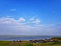
The district has several beels, the largest of which is Chalan Beel on the border with Pabna district.
Sirajganj district is in the Jamuna river basin. The Jamuna forms the eastern border of the district. It contains numerous small chars. The Karatoya river flows into Tarash upazila from Bogura district and flows southeast. It sends distributaries to the Bangali, a previous distributary which flows parallel to it on the east. These rivers flow into the Hurasagar river on Sirajganj's southwest border, which flows southeast into the Jamuna.
Demographics
[edit]| Year | Pop. | ±% p.a. |
|---|---|---|
| 1974 | 1,559,007 | — |
| 1981 | 1,878,025 | +2.70% |
| 1991 | 2,263,573 | +1.88% |
| 2001 | 2,693,814 | +1.76% |
| 2011 | 3,097,489 | +1.41% |
| 2022 | 3,357,706 | +0.74% |
| Sources:[2][7] | ||
According to the 2022 Census of Bangladesh, Sirajganj District has 842,308 households and a population of 3,357,706 with an average 3.93 people per household. Among the population, 651,384 (19.40%) inhabitants are under 10 years of age. The population density is 1,398 people per km2. Sirajganj District has a literacy rate (age 7 and over) of 69.48%, compared to the national average of 74.80%, and a sex ratio of 98.51 males per 100 females. Approximately, 20.25% (680,019) of the population live in urban areas. The ethnic population is 20,319 (0.61%), concentrated in Rayganj and Taras upazilas.[2]
Religion
[edit]| Religion | 1941[9]: 96–97 [a] | 1981[7] | 1991[7] | 2001[7] | 2011[7] | 2022[8] | ||||||
|---|---|---|---|---|---|---|---|---|---|---|---|---|
| Pop. | % | Pop. | % | Pop. | % | Pop. | % | Pop. | % | Pop. | % | |
| Islam |
816,539 | 79.52% | 1,726,967 | 91.96% | 2,114,864 | 93.43% | 2,551,708 | 94.72% | 2,948,505 | 95.19% | 3,210,116 | 95.61% |
| Hinduism |
204,842 | 19.95% | 149,479 | 7.96% | 146,032 | 6.45% | 141,406 | 5.25% | 147,514 | 4.76% | 146,523 | 4.37% |
| Others [b] | 5497 | 0.54% | 1,579 | 0.08% | 2,677 | 0.12% | 700 | 0.03% | 1,470 | 0.05% | 1,067 | 0.02% |
| Total Population | 1,026,878 | 100% | 1,878,025 | 100% | 2,263,573 | 100% | 2,693,814 | 100% | 3,097,489 | 100% | 3,357,706 | 100% |
Muslims make up 95.61% of the population, while Hindus are 4.37% of the population. The Hindu population has remained relatively constant while the Muslim population has constantly increased. The remaining 0.02% people follow other religions, mainly Christianity and Sarnaism.[7][1]
Economy
[edit]Sirajganj is home to Sirajganj Economic Zone, the largest private economic zone in Bangladesh as of March 2024 spanning 1,041 acres of land . The government is building a flyover to link the zone with the Dhaka-Bogura Highway. The zone supplies water from Jamuna river after treatment.[10]
As of June 2024, Sirajganj has a growing dairy market worth over BDT 100 core and receiving export orders. There are around 33,000 dairy farms in Sirajganj.[11]
Points of interest
[edit]- Chalan Beel : Chalan Beel is a wetland in Bangladesh. It is a large inland depression, marshy in character, with rich flora and fauna. Forty-seven rivers and other waterways flow into the Chalan Beel. As silt builds up in the beel, its size is being reduced.
- Homestead of Behula
- Shiva Temple
- Maha Prabhu Temple
- Gopinath Bigraha
- Kalika Debi Bigraha
- Pratap Dighi
- Joysagar Dighi
- House of Suchitra Sen
- Sirajganj Road : Sirajganj Road is one of the most important crossroads of entire Bangladesh
- Sirajganj Economic Zone
- China Barrages : There are four barrages located near Sirajganj city which are also a part of Sirajganj economic zone.
- Sirajganj Hard point
- Jamuna Eco Park
- Tarash Palace
- Navaratna Temple
- Katar Mahal Jamidar bari
- Rautara Jamidar bari
- Sannal Jamidar bari
- Elliott Bridge : A bridge located in the centre of the Sirajganj city.
- Makka Aoulia Mosque
- Shahjadpur Dargah Mosque
- Shahjadpur Kachharibari
- Tomb of Khaja Yunus Ali Enaetpuri
- Tomb of Shamsuddin Tabrizi
- Tomb of Abdul Ali Baki Shah
- Tomb of Makhdum Shah Doula
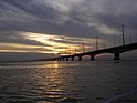
- Jamuna Bridge : Also known as the Bangabandhu Bridge. It is 4.8 kilometers long and it has 50 pillars and 49 spans.
- House of Maulana Abdul Hamid Khan Bhasani
- House of Syed Ismail Hossain Siraji
- Rasel Park
- Milkvita
- Baghabari Riverport
- Meghai Riverport
Administration
[edit]Sirajganj Sub-division was established in 1885 under Pabna district and it was turned into a district in 1984. Of the nine upazilas of the district Ullahpara is the largest (414.43 square kilometres (160.01 sq mi)) and Kamarkhanda is the smallest (91.61 square kilometres (35.37 sq mi)). Moreover, the district has six municipals, six Parliament seats, 82 unions and 2016 villages.
List of Upazilas
[edit]There are nine (9) Upazilas, namely :
- Sirajganj Sadar Upazila
- Kazipur Upazila
- Ullahpara Upazila
- Shahjadpur Upazila
- Raiganj Upazila
- Kamarkhanda Upazila
- Tarash Upazila
- Belkuchi Upazila
- Chauhali Upazila
Transport
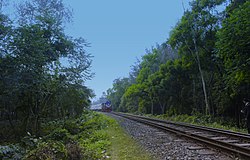
[edit]Sirajganj District's transportation system is very good. It has the most important highway and railway of Bangladesh which connects the entire North Bengal and a part of South Bengal with the rest of the country. It is very easy to travel through the district because of its great transport system. It has the 2nd largest bridge Jamuna Bridge and the largest railway bridge of Bangladesh. Sirajganj District is also famous for its River-ports.
Like many other districts in Bangladesh, Sirajganj is also a district with many rivers. The main bridges are Bangabandhu Multipurpose Bridge over the River Jamuna, Nalka Bridge Over the River Foljodre, Eliot Bridge etc.
Education
[edit]There are 3 medical colleges in the district, the public Shaheed M. Monsur Ali Medical College, established in 2014, the private North Bengal Medical College & Hospital, established in 2000, and the private Khwaja Yunus Ali Medical College & Hospital, established in 2005. They are respectively allowed to admit 65, 85, and 95 students annually.[12]
There are 2 universities in the district, the public Rabindra University, established in 2017 and the private Khwaja Yunus Ali University, established in 2012.
There are 6 government colleges under National University in the district. They are Islamia Government College, Government Akbar Ali College, Sirajganj Government College, Government Kazipur Mansur Ali College, Government Rashidazzoha Womens College, Government Shahjadpur College.[13][4]
There are 3 government high schools in the district. They are B.L. Government Boys High School, Saleha Ishaque Government Girls High School and Kazipur A.M.U. Government Girls High School.
Notable people
[edit]This article's list of residents may not follow Wikipedia's verifiability policy. (April 2022) |
- Abdul Hamid Khan Bhashani[14][15]
- Abdur Rashid Tarkabagish[16]
- Captain M. Monsur Ali[17]
- Jadav Chandra Chakravarti[18]
- Suchitra Sen[19]
- Ismail Hossain Siraji[20]
- Rajanikanta Sen
- Abdul Matin
- Abdul Latif Mirza[21]
- Mahadev Saha
- Rajendra Lahiri
- Makhdum Shah
- Haimanti Sukla[18]
- Abdullah-Al-Muti[22]
- Ishan Chandra Roy
- Bappi Lahiri
- Mohammad Najibar Rahman
- K G Mustafa
- Fateh Lohani
- Khwaja Yunus Ali
- Abu Hena Mustafa Kamal
- Fazle Lohani
- Shakila Zafar
- Mokbula Manzoor
- Hossain Toufique Imam
- Kamal Lohani
- Mohammed Nasim
- Tauquir Ahmed
- Zahid Hasan[23][24]
- M.A.Matin
- Kanak Chapa
- Arifur Rahman[25]
- Mohammad Barkatullah
- Samudra Gupta
- Abdul Mannan Talukder
- Mak Yuree
- Husna Banu Khanam
- Abdullah al Mahmood
- Gazi M M Amjad Hossain
- Iqbal Hasan Mahmud Tuku
- Ataur Rahman
- Mazharul Islam[26]
- G.A.K. Lohani
- Syeda Issabela
- Amanul Haque
- Motahar Hossain Talukdar
- Kshitish Mohan Lahiri
- Sezan Mahmud
- Abdul Hai Sarker
- Imtiar Shamim
- Kabir Bin Anwar
- Uzzal
- Ibne Mizan
- Dewan Nazrul
- Ali Raj
- M. Rafiqul Islam
- Abdul Latif Mirza
- Malay Bhowmick
- Talukder Moniruzzaman
- Rumana Mahmood
- Abdul Latif Biswas
- Tanveer Imam
- Abdul Momin Talukdar
- Abu Hasan Shahriar
- Hashibur Rahman Swapon
- Manzur Quader
- Abdul Majid Mandal
- Mozammel Haque
- Mirza Muraduzzaman
- Kamruddin Ahia Khan Majlish
- M Akbar Ali
- Ishaque Hossain Talukder
- Ansar Ali Siddiqui
- Mohammad Selim
- Shahidullah Khan
- Md. Habibe Millat
- Mofiz Uddin Talukder
- Dabir Uddin Ahmed
- Rafiqul Islam Bakul
- Syed Hossain Mansur
- Choyon Islam
- Tanvir Shakil Joy
- Shahidul Islam Khan
- Amanul Haque
- Afiea Nusrat Barsha
- Akhi Khatun
Notes
[edit]References
[edit]- ^ a b Population and Housing Census 2022 - District Report: Sirajganj (PDF). District Series. Dhaka: Bangladesh Bureau of Statistics. June 2024. ISBN 978-984-475-229-0.
- ^ a b c Population and Housing Census 2022 National Report (PDF). Vol. 1. Bangladesh Bureau of Statistics. November 2023.
- ^ "Sub-national HDI - Area Database - Global Data Lab". hdi.globaldatalab.org. Retrieved 2020-03-18.
- ^ a b Kamrul Islam (2012). "Sirajganj District". In Sirajul Islam; Miah, Sajahan; Khanam, Mahfuza; Ahmed, Sabbir (eds.). Banglapedia: the National Encyclopedia of Bangladesh (Online ed.). Dhaka, Bangladesh: Banglapedia Trust, Asiatic Society of Bangladesh. ISBN 984-32-0576-6. OCLC 52727562. OL 30677644M. Retrieved 30 November 2024.
- ^ E M Lewis (1868). "Mymensingh District". Principal Heads of the History and Statistics of the Dacca Division. Calcutta: Calcutta Central Press Company. p. 213.
- ^ "The Salanga Massacre of 1922: Bangladesh's forgotten bloodbath", by Shahnawaz Khan Chandan, The Daily Star (Dhaka), January 25, 2019)
- ^ a b c d e f "Bangladesh Population and Housing Census 2011 Zila Report – Sirajganj" (PDF). Bangladesh Bureau of Statistics.
- ^ a b Population and Housing Census 2022 District Census Handbook: Sirajganj (PDF). Vol. 1. Bangladesh Bureau of Statistics. July 2024.
- ^ "Census of India, 1941 Volume VI Bengal Province" (PDF).
- ^ "A dream emerges along Jamuna as Sirajganj EZ gears up for production early next year". The Business Standard. 2024-03-16. Retrieved 2024-06-26.
- ^ "Sirajganj's Tk100cr dairy market thrives on milk production boom". The Business Standard. 2024-06-26. Retrieved 2024-06-26.
- ^ "Statistical Year Book Bangladesh 2018" (PDF). Bangladesh Bureau of Statistics. May 2019. pp. 485–486.
- ^ "List of Colleges". Department of Secondary and Higher Education. Retrieved 6 September 2020.
- ^ Sartori, Andrew (2014). Liberalism in Empire: An Alternative History. University of California Press. p. 186. ISBN 978-0-520-95757-2.
- ^ "Maulana Abdul Hamid Khan Bhashani". Encyclopedia of World Biography Online. Gale. 1998. Retrieved 2 April 2022.
- ^ Rozina Kader (2012). "Tarkabagish, Maulana Abdur Rashid". In Sirajul Islam; Miah, Sajahan; Khanam, Mahfuza; Ahmed, Sabbir (eds.). Banglapedia: the National Encyclopedia of Bangladesh (Online ed.). Dhaka, Bangladesh: Banglapedia Trust, Asiatic Society of Bangladesh. ISBN 984-32-0576-6. OCLC 52727562. OL 30677644M. Retrieved 30 November 2024.
- ^ Md. Azom Baig (2012). "Ali, Captain M Mansur". In Sirajul Islam; Miah, Sajahan; Khanam, Mahfuza; Ahmed, Sabbir (eds.). Banglapedia: the National Encyclopedia of Bangladesh (Online ed.). Dhaka, Bangladesh: Banglapedia Trust, Asiatic Society of Bangladesh. ISBN 984-32-0576-6. OCLC 52727562. OL 30677644M. Retrieved 30 November 2024.
- ^ a b ভাষা ও সংস্কৃতি [Language and culture]. Sirajganj District (in Bengali).
- ^ Topu, Ahmed Humayun Kabir (7 April 2009). "Screen legend Suchitra Sen's ancestral home occupied". The Daily Star.
- ^ Rana Razzaq (2012). "Shiraji, Ismail Hossain". In Sirajul Islam; Miah, Sajahan; Khanam, Mahfuza; Ahmed, Sabbir (eds.). Banglapedia: the National Encyclopedia of Bangladesh (Online ed.). Dhaka, Bangladesh: Banglapedia Trust, Asiatic Society of Bangladesh. ISBN 984-32-0576-6. OCLC 52727562. OL 30677644M. Retrieved 30 November 2024.
- ^ "Former AL MP Abdul Latif Mirza dies at 63". bdnews24.com. 5 November 2007.
- ^ Sajahan Miah (2012). "Sharafuddin, Abdullah Al-Muti". In Sirajul Islam; Miah, Sajahan; Khanam, Mahfuza; Ahmed, Sabbir (eds.). Banglapedia: the National Encyclopedia of Bangladesh (Online ed.). Dhaka, Bangladesh: Banglapedia Trust, Asiatic Society of Bangladesh. ISBN 984-32-0576-6. OCLC 52727562. OL 30677644M. Retrieved 30 November 2024.
- ^ Shazu, Shah Alam (1 December 2010). "'I always work in my own way'". The Daily Star.
- ^ Shazu, Shah Alam (4 October 2017). "Birthday felicitations for Zahid Hasan!". The Daily Star.
- ^ "Får endelig tegne hva han vil". Journalen (in Norwegian Bokmål). Oslo Metropolitan University. 31 May 2011.
- ^ Hossain, Selina; Islam, Nurul; Hossain, Mobarak, eds. (2000). Bangla Academy Dictionary of Writers. Bangla Academy. p. 115. ISBN 984-07-4052-0.
- Bangladesh Population Census 2011.
- Bangladesh Bureau of Statistics.
- Cultural survey report of Sirajganj District 2007:
- Cultural survey report of Upazilas of Sirajganj District 2007.
See more
[edit]- Tangail
External links
[edit]| Barisal Division |
|  |
|---|---|---|
| Chittagong Division |
| |
| Dhaka Division |
| |
| Khulna Division |
| |
| Mymensingh Division |
| |
| Rajshahi Division |
| |
| Rangpur Division |
| |
| Sylhet Division |
| |
Authority control databases | |
|---|---|
| International | |
| National | |
| Geographic | |
Original source: https://en.wikipedia.org/wiki/Sirajganj District
Status: article is cached
 EncycloReader
is supported by the
EncycloReader
is supported by the