Třebonín
 From Wikipedia - Reading time: 7 min
Třebonín | |
|---|---|
Municipality | |
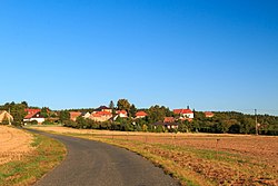 View from the southeast | |
 Flag  Coat of arms | |
 Třebonín Location in the Czech Republic | |
| Coordinates: 49°52′11″N 15°18′47″E / 49.86972°N 15.31306°E | |
| Country | |
| Region | Central Bohemian |
| District | Kutná Hora |
| First mentioned | 1194 |
| Area | |
| • Total | 3.42 km2 (1.32 sq mi) |
| Elevation | 340 m (1,120 ft) |
| Population (2024-01-01)[1] | |
| • Total | 138 |
| • Density | 40/km2 (100/sq mi) |
| Time zone | UTC+1 (CET) |
| • Summer (DST) | UTC+2 (CEST) |
| Postal code | 285 44 |
| Website | www |
Třebonín is a municipality and village in Kutná Hora District in the Central Bohemian Region of the Czech Republic. It has about 100 inhabitants.
Demographics
[edit]| Year | Pop. | ±% |
|---|---|---|
| 1869 | 384 | — |
| 1880 | 403 | +4.9% |
| 1890 | 376 | −6.7% |
| 1900 | 376 | +0.0% |
| 1910 | 362 | −3.7% |
| 1921 | 355 | −1.9% |
| 1930 | 279 | −21.4% |
| 1950 | 231 | −17.2% |
| 1961 | 195 | −15.6% |
| 1970 | 164 | −15.9% |
| 1980 | 169 | +3.0% |
| 1991 | 122 | −27.8% |
| 2001 | 125 | +2.5% |
| 2011 | 133 | +6.4% |
| 2021 | 139 | +4.5% |
| Source: Censuses[2][3] | ||
References
[edit]- ^ "Population of Municipalities – 1 January 2024". Czech Statistical Office. 2024-05-17.
- ^ "Historický lexikon obcí České republiky 1869–2011" (in Czech). Czech Statistical Office. 2015-12-21.
- ^ "Population Census 2021: Population by sex". Public Database. Czech Statistical Office. 2021-03-27.
External links
[edit]Wikimedia Commons has media related to Třebonín.
| Authority control databases: National |
|---|
This article is licensed under CC BY-SA 3.0.
Original source: https://en.wikipedia.org/wiki/Třebonín
Status: article is cached
Original source: https://en.wikipedia.org/wiki/Třebonín
Status: article is cached
 EncycloReader
is supported by the
EncycloReader
is supported by the