Categories
Tigheville, West Virginia
 From Wikipedia - Reading time: 5 min
Tigheville | |
|---|---|
Unincorporated community | |
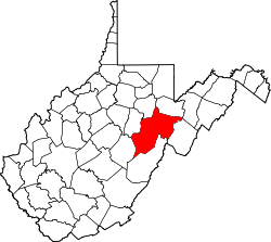
 Tigheville Location within the state of West Virginia  Tigheville Tigheville (the United States) | |
| Coordinates: 38°58′47″N 79°55′11″W / 38.97972°N 79.91972°W | |
| Country | United States |
| State | West Virginia |
| County | Randolph |
| Elevation | 1,955 ft (596 m) |
| Time zone | UTC-5 (Eastern (EST)) |
| • Summer (DST) | UTC-4 (EDT) |
| GNIS ID | 1555813[1] |
Tigheville is an unincorporated community in Randolph County, West Virginia, United States.
References
[edit]Municipalities and communities of Randolph County, West Virginia, United States | ||
|---|---|---|
County seat: Elkins | ||
| City |
|  |
| Towns |
| |
| CDPs |
| |
| Other communities |
| |
| Ghost towns |
| |
| Footnotes | ‡This populated place also has portions in an adjacent county or counties | |
| ||
This article about a location in Randolph County, West Virginia is a stub. You can help Wikipedia by expanding it. |
This article is licensed under CC BY-SA 3.0.
Original source: https://en.wikipedia.org/wiki/Tigheville, West Virginia
Status: article is cached
Original source: https://en.wikipedia.org/wiki/Tigheville, West Virginia
Status: article is cached
 EncycloReader
is supported by the
EncycloReader
is supported by the