Trstěnice (Svitavy District)
 From Wikipedia - Reading time: 6 min
Trstěnice | |
|---|---|
Municipality | |
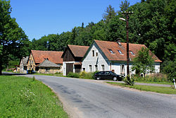 Northern part of Trstěnice | |
 Flag  Coat of arms | |
 Trstěnice Location in the Czech Republic | |
| Coordinates: 49°47′39″N 16°20′56″E / 49.79417°N 16.34889°ECoordinates: 49°47′39″N 16°20′56″E / 49.79417°N 16.34889°E | |
| Country | |
| Region | Pardubice |
| District | Svitavy |
| First mentioned | 993 |
| Area | |
| • Total | 21.48 km2 (8.29 sq mi) |
| Elevation | 423 m (1,388 ft) |
| Population (2022-01-01)[1] | |
| • Total | 523 |
| • Density | 24/km2 (63/sq mi) |
| Time zone | UTC+1 (CET) |
| • Summer (DST) | UTC+2 (CEST) |
| Postal code | 569 57 |
| Website | www |
Trstěnice is a municipality and village in Svitavy District in the Pardubice Region of the Czech Republic. It has about 500 inhabitants.
History[edit]

Bell tower
The first written mention of Trstěnice is from 993. The village gave its name to the Trstěnice Route, which was an important medieval trade route that connected Bohemia and Moravia.[2]
Sights[edit]
The Church of the Finding of the Holy Cross was first documented in 1350. It is originally a Gothic building, later baroquized. A bell tower from 1690 stands next to it separately. It is one of the most valuable fortificated church complexes in Bohemia.[3]
References[edit]
- ^ "Population of Municipalities – 1 January 2022". Czech Statistical Office. 2022-04-29.
- ^ "Trstěnická stezka" (in Czech). Obec Trstěnice. Retrieved 2021-10-16.
- ^ "Kostel Nalezení sv. Kříže" (in Czech). National Heritage Institute. Retrieved 2021-10-16.
External links[edit]
Wikimedia Commons has media related to Trstěnice (Svitavy District).
| Authority control: National libraries |
|---|
This Pardubice Region location article is a stub. You can help Wikipedia by expanding it. |
This article is licensed under CC BY-SA 3.0.
Original source: https://en.wikipedia.org/wiki/Trstěnice (Svitavy District)
Status: article is cached
Original source: https://en.wikipedia.org/wiki/Trstěnice (Svitavy District)
Status: article is cached
 EncycloReader
is supported by the
EncycloReader
is supported by the