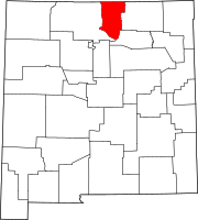
Arroyo Hondo, Taos County, New Mexico
 From Wikipedia - Reading time: 8 min
Arroyo Hondo | |
|---|---|
 Nuestra Señora de Dolores Catholic Church | |
| Coordinates: 36°49′09″N 105°56′23″W / 36.81917°N 105.93972°W | |
| Country | United States |
| State | New Mexico |
| County | Taos |
| Government | |
| • Type | unincorporated community |
| Area | |
• Total | 1.65 sq mi (4.27 km2) |
| • Land | 1.65 sq mi (4.27 km2) |
| • Water | 0.00 sq mi (0.00 km2) |
| Elevation | 6,962 ft (2,122 m) |
| Population | |
• Total | 428 |
| • Density | 259.71/sq mi (100.29/km2) |
| Time zone | UTC−7 (Mountain (MST)) |
| • Summer (DST) | UTC−6 (MDT) |
| ZIP code | 87513 |
| Area code | 575 |
| FIPS code | 35-05010 |
| GNIS feature ID | 2812758[2] |
Arroyo Hondo is a census-designated place in Taos County near Taos, New Mexico, United States. As of the 2010 census it had a population of 474.[4]
History
[edit]It is historically notable as the site of the killing of six to eight employees by a force of allied Native Americans at Simeon Turley's mill and distillery trading post on January 20, 1847.[5][6] This took place during the Taos Revolt, a populist insurrection of New Mexicans and Native Americans against the new United States territorial regime during the Mexican–American War.[7][8]
Demographics
[edit]| Census | Pop. | Note | %± |
|---|---|---|---|
| 2020 | 428 | — | |
| U.S. Decennial Census[9] | |||
Education
[edit]It is within Taos Municipal Schools,[10] which operates Taos High School.
See also
[edit]Wikimedia Commons has media related to Arroyo Hondo, New Mexico.
References
[edit]- ^ "ArcGIS REST Services Directory". United States Census Bureau. Retrieved October 12, 2022.
- ^ a b U.S. Geological Survey Geographic Names Information System: Arroyo Hondo, Taos County, New Mexico
- ^ "Census Population API". United States Census Bureau. Retrieved October 12, 2022.
- ^ "Race; 2010 DEC Redistricting Data (PL 94-171): Arroyo Hondo CDP, Taos County, New Mexico". data.census.gov. U.S. Census Bureau. Retrieved July 19, 2021.
- ^ Simmons, Marc. "Trail Dust: Pionner Tobin led life of adventure". The Santa Fe New Mexican. Retrieved November 12, 2012.
- ^ Schaubs, Michael. "Simeon Turley - Distiller". Retrieved September 9, 2016.
- ^ Lyckman, Ernest (1988). "A Review of the Ranch, Trading Post, Mill and Distillery of Simeon Turley, Canoncito, Arroyo Hondo, Taos County, New Mexico 1830-1847". Ayer y Hoy en Taos: Yesterday and Today in Taos County and Northern New Mexico (6). Taos, NM: Taos County Historical Society: 3–5.
- ^ Price, Sterling (April 30, 1847). "From New Mexico: Headquarters Army in New Mexico, Santa Fe, Feb 15, 1847". Wilmington Journal (Wilmington, North Carolina). p. 2.
- ^ "Census of Population and Housing". Census.gov. Retrieved June 4, 2016.
- ^ "2020 CENSUS - SCHOOL DISTRICT REFERENCE MAP: Taos County, NM" (PDF). U.S. Census Bureau. Retrieved July 12, 2022.
36°32′09″N 105°40′09″W / 36.5358°N 105.6692°W
Licensed under CC BY-SA 3.0 | Source: https://en.wikipedia.org/wiki/Arroyo_Hondo,_Taos_County,_New_Mexico17 views | Status: cached on March 28 2025 17:54:27↧ Download as ZWI file
 KSF
KSF

