Baft
 From Wikipedia - Reading time: 9 min
Baft
Persian: بافت | |
|---|---|
City | |
 | |
| Coordinates: 29°14′06″N 56°35′56″E / 29.23500°N 56.59889°E[1] | |
| Country | Iran |
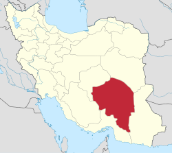
| Province | Kerman |
| County | Baft |
| District | Central |
| Elevation | 2,280 m (7,480 ft) |
| Population (2016)[2] | |
• Total | 34,517 |
| Time zone | UTC+3:30 (IRST) |
| Area code | 0347422 |
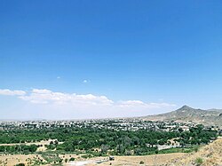
Baft (Persian: بافت)[a] is a city in the Central District of Baft County, Kerman province, Iran, serving as capital of both the county and the district.[4] It is 155 kilometres (96 mi) southwest of Kerman. Baft has an elevation of about 2,280 metres (7,480 ft).[citation needed]
Demographics
[edit]Population
[edit]At the time of the 2006 National Census, the city's population was 35,008 in 8,265 households.[5] The following census in 2011 counted 33,107 people in 8,473 households.[6] The 2016 census measured the population of the city as 34,517 people in 10,035 households.[2]
Climate
[edit]| Climate data for Baft (1991–2020, extremes since 1989) | |||||||||||||
|---|---|---|---|---|---|---|---|---|---|---|---|---|---|
| Month | Jan | Feb | Mar | Apr | May | Jun | Jul | Aug | Sep | Oct | Nov | Dec | Year |
| Record high °C (°F) | 20.0 (68.0) |
22.4 (72.3) |
27.0 (80.6) |
27.4 (81.3) |
33.8 (92.8) |
37.0 (98.6) |
36.8 (98.2) |
36.6 (97.9) |
33.5 (92.3) |
28.9 (84.0) |
24.2 (75.6) |
24.0 (75.2) |
37.0 (98.6) |
| Mean daily maximum °C (°F) | 9.6 (49.3) |
11.5 (52.7) |
15.2 (59.4) |
20.6 (69.1) |
26.3 (79.3) |
31.1 (88.0) |
32.5 (90.5) |
31.3 (88.3) |
28.3 (82.9) |
23.0 (73.4) |
16.5 (61.7) |
12.5 (54.5) |
21.5 (70.7) |
| Daily mean °C (°F) | 3.5 (38.3) |
5.5 (41.9) |
9.1 (48.4) |
14.6 (58.3) |
20.2 (68.4) |
24.9 (76.8) |
26.2 (79.2) |
24.9 (76.8) |
21.9 (71.4) |
16.2 (61.2) |
9.8 (49.6) |
5.9 (42.6) |
15.2 (59.4) |
| Mean daily minimum °C (°F) | −1.6 (29.1) |
0.1 (32.2) |
3.5 (38.3) |
8.4 (47.1) |
13.2 (55.8) |
17.8 (64.0) |
19.8 (67.6) |
18.4 (65.1) |
15.2 (59.4) |
9.6 (49.3) |
3.7 (38.7) |
0.3 (32.5) |
9.0 (48.2) |
| Record low °C (°F) | −16.6 (2.1) |
−11.6 (11.1) |
−7.6 (18.3) |
−2.0 (28.4) |
4.6 (40.3) |
9.5 (49.1) |
14.5 (58.1) |
12.6 (54.7) |
6.6 (43.9) |
2.8 (37.0) |
−7.5 (18.5) |
−10.6 (12.9) |
−16.6 (2.1) |
| Average precipitation mm (inches) | 52.1 (2.05) |
53.1 (2.09) |
51.1 (2.01) |
24.1 (0.95) |
8.9 (0.35) |
1.8 (0.07) |
5.0 (0.20) |
11.2 (0.44) |
1.3 (0.05) |
4.9 (0.19) |
12.0 (0.47) |
33.5 (1.32) |
259.0 (10.20) |
| Average precipitation days (≥ 1.0 mm) | 4.8 | 5.1 | 5.5 | 3.5 | 1.7 | 0.3 | 1.1 | 1.9 | 0.5 | 1.0 | 2.0 | 3.3 | 30.7 |
| Average relative humidity (%) | 52.0 | 50.0 | 46.0 | 39.0 | 30.0 | 24.0 | 27.0 | 26.0 | 28.0 | 34.0 | 43.0 | 48.0 | 37.3 |
| Average dew point °C (°F) | −6.6 (20.1) |
−5.4 (22.3) |
−3.5 (25.7) |
−0.6 (30.9) |
0.6 (33.1) |
1.8 (35.2) |
4.2 (39.6) |
2.8 (37.0) |
1.0 (33.8) |
−0.7 (30.7) |
−3.5 (25.7) |
−5.9 (21.4) |
−1.3 (29.7) |
| Mean monthly sunshine hours | 226 | 216 | 243 | 268 | 318 | 313 | 301 | 317 | 296 | 294 | 251 | 239 | 3,282 |
| Source: NOAA,[7] IRIMO[8][9] | |||||||||||||
Khabr National Park
[edit]Baft is one of the natural areas in Iran. Within its locale is the Khabr National Park, which has been submitted by Iran as a UNESCO world heritage site.[10] Khabr National Park has a rich flora (about 750 species) and about 120 endemic species.[citation needed]
See also
[edit]Notes
[edit]References
[edit]- ^ OpenStreetMap contributors (3 December 2024). "Baft, Baft County" (Map). OpenStreetMap (in Persian). Retrieved 3 December 2024.
- ^ a b Census of the Islamic Republic of Iran, 1395 (2016): Kerman Province. amar.org.ir (Report) (in Persian). The Statistical Center of Iran. Archived from the original (Excel) on 20 October 2020. Retrieved 19 December 2022.
- ^ Baft can be found at GEOnet Names Server, at this link, by opening the Advanced Search box, entering "-3054465" in the "Unique Feature Id" form, and clicking on "Search Database".
- ^ Habibi, Hassan (c. 2024) [Approved 21 June 1369]. Approval of the organization and chain of citizenship of the elements and units of the national divisions of Kerman province, centered in the city of Kerman. lamtakam.com (Report) (in Persian). Ministry of the Interior, Defense Political Commission of the Government Council. Proposal 3233.1.5.53; Letter 907-93808; Notification 82812/T139K. Archived from the original on 30 January 2024. Retrieved 30 January 2024 – via Lam ta Kam.
- ^ Census of the Islamic Republic of Iran, 1385 (2006): Kerman Province. amar.org.ir (Report) (in Persian). The Statistical Center of Iran. Archived from the original (Excel) on 20 September 2011. Retrieved 25 September 2022.
- ^ Census of the Islamic Republic of Iran, 1390 (2011): Kerman Province. irandataportal.syr.edu (Report) (in Persian). The Statistical Center of Iran. Archived from the original (Excel) on 29 March 2023. Retrieved 19 December 2022 – via Iran Data Portal, Syracuse University.
- ^ "World Meteorological Organization Climate Normals for 1991-2020 — Baft". National Oceanic and Atmospheric Administration. Retrieved 31 December 2023.
- ^ "TEMPERATURE RECORDS LOWEST IN C. for Baft (40853)". chaharmahalmet. IRIMO. Archived from the original (asp) on 4 January 2017. Retrieved 27 May 2025.
- ^ "TEMPERATURE RECORDS HIGHEST IN C. for Baft (40853)". chaharmahalmet. IRIMO. Archived from the original (asp) on 4 January 2017. Retrieved 27 May 2025.
- ^ UNESCO World Heritage Centre (2007) Khabr National Park and Ruchun Wildlife Refuge, web page, online at https://whc.unesco.org/en/tentativelists/5219/, visited 2015-03-28
 KSF
KSF
