Categories
Beniamin
 From Wikipedia - Reading time: 8 min
Beniamin
Բենիամին Chalovkhan | |
|---|---|
 | |
 Beniamin  Beniamin | |
| Coordinates: 40°41′N 43°51′E / 40.683°N 43.850°E | |
| Country | Armenia |
| Province | Shirak |
| Municipality | Akhuryan |
| Elevation | 1,540 m (5,050 ft) |
| Population (2011) | |
• Total | 724[1] |
| Time zone | UTC+4 |
| • Summer (DST) | UTC+5 |
| Beniamin at GEOnet Names Server | |
Beniamin (Armenian: Բենիամին) is a village in the Akhuryan Municipality of the Shirak Province of Armenia. The town was renamed in 1945 in honor of Beniamin Galstian, a World War II general and native of the town.[2] According to Ghevont Alishan, the old name of the village is "Chlofkhan or Chalovkhan", and was founded in 1828-1830 in the territory of the historical city of Draskhanakert.[3] The Statistical Committee of Armenia reported its population was 745 in 2010,[4] up from 702 at the 2001 census.[5]
Demographics
[edit]| Year | Pop. | ±% p.a. | ||
|---|---|---|---|---|
| 1897 | 561 | — | ||
| 1926 | 442 | −0.82% | ||
| 1939 | 604 | +2.43% | ||
| 1959 | 546 | −0.50% | ||
| 1970 | 531 | −0.25% | ||
| 1979 | 500 | −0.67% | ||
| 1989 | 751 | +4.15% | ||
| 2001 | 702 | −0.56% | ||
| 2011 | 724 | +0.31% | ||
| ||||
| Source: [6] | ||||
Historical and cultural structures
[edit]"Tukh Manuk" chapel and Zham church are located in Beniamin.[7]
Education
[edit]There is a school in the village, where, in addition to the school curriculum, children are involved in extracurricular programs: art and craft groups, debate club, healthy lifestyle seminars.
With the efforts of the Children of Armenia Fund, trainings are being carried out for local medical workers.
Gallery
[edit]-
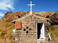 "Tukh Manuk" chapel
 -
 Monument in the honor of Armenians who fought in the Great Patriotic War
 -
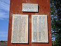 Monument in the honor of Armenians who fought in the Great Patriotic War
 -
 Monument to General Major Benjamin Hovhannes Galstyan, Hero of the Soviet Union
 -
 Beniamin school
 -
 Beniamin church (Zham), 1871


References
[edit]- ^ "Shirak (Armenia): Towns and Villages in Municipalities". www.citypopulation.de. Retrieved 2025-06-19.
- ^ Kiesling, Brady (June 2000). Rediscovering Armenia: An Archaeological/Touristic Gazetteer and Map Set for the Historical Monuments of Armenia (PDF). Archived (PDF) from the original on 6 November 2021.
- ^ Alishan, Ghevont (1881). Shirak (in Armenian). Venice.
{{cite book}}: CS1 maint: location missing publisher (link) - ^ "Marzes of Armenia and Yerevan City in Figures, 2010" (PDF). Statistical Committee of Armenia.
- ^ Report of the results of the 2001 Armenian Census, Statistical Committee of Armenia
- ^ Հայաստանի Հանրապետության բնակավայրերի բառարան [Republic of Armenia settlements dictionary] (PDF) (in Armenian). Yerevan: Cadastre Committee of the Republic of Armenia. 2008. Archived from the original (PDF) on 11 March 2018.
- ^ hushardzantest. "ԲԵՆԻԱՄԻՆ". Պատմամշակութային արգելոց-թանգարանների և պատմական միջավայրի պահպանության ծառայության (in Amharic). Retrieved 2022-08-20.
Capital: Gyumri | ||
| Urban settlements |  | |
| Akhuryan Municipality | ||
| Amasia Municipality | ||
| Ani Municipality | ||
| Artik Municipality | ||
| Ashotsk Municipality | ||
This article about a location in Shirak Province, Armenia is a stub. You can help Wikipedia by expanding it. |
 EncycloReader
is supported by the
EncycloReader
is supported by the