Benzie County, Michigan
 From Wikipedia - Reading time: 12 min
Benzie County | |
|---|---|
 | |
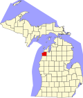
 Location within the U.S. state of Michigan | |
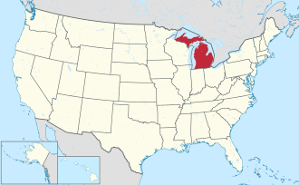
 Michigan's location within the U.S. | |
| Coordinates: 44°38′N 86°15′W / 44.63°N 86.25°W | |
| Country | |
| State | |
| Founded | 1863 (created) 1869 (organized)[1] |
| Named after | Betsie River |
| Seat | Beulah |
| Largest city | Frankfort |
| Area | |
• Total | 860 sq mi (2,200 km2) |
| • Land | 320 sq mi (800 km2) |
| • Water | 540 sq mi (1,400 km2) 63% |
| Population (2020) | |
• Total | 17,970 |
• Estimate (2024) | 18,520 |
| • Density | 55/sq mi (21/km2) |
| Time zone | UTC−5 (Eastern) |
| • Summer (DST) | UTC−4 (EDT) |
| Congressional district | 1st |
| Website | www |
Benzie County (/ˈbɛnziː/ BEN-zee) is a county in the U.S. state of Michigan. As of the 2020 census, the population was 17,970.[2] The county seat is Beulah.[3] The county was initially set off in 1863 and organized in 1869.[1][4] At 321 square miles (830 km2), Benzie County is the smallest of the 83 counties in Michigan in terms of land area.
Benzie County is part of the Traverse City metropolitan area. Part of the Sleeping Bear Dunes National Lakeshore is located within the county. It is also home to Crystal Mountain, one of Michigan's top-rated ski resorts.[5]


History
[edit]Today's Benzie County was originally part of Leelanau County. Leelanau County was separated from Michilimackinac County in 1840, and was attached to Grand Traverse County.[6] In 1863, The northern section of Leelanau County was organized, and the southern section, now named Benzie County, was left attached to Grand Traverse County.[7] Benzie County was organized in its own right in 1869.[1][4]
Etymology
[edit]The name "Benzie" is derived from the French la rivière aux Bec-scies, "the river of sawbills", bec-scie ("bill-saw") being a type of ducks. Americans altered the pronunciation of the river's name, which became known as the "Betsie River". A similar alteration in pronunciation produced "Benzie".[1]
Geography
[edit]According to the U.S. Census Bureau, the county has a total area of 860 square miles (2,200 km2), of which 320 square miles (830 km2) is land and 540 square miles (1,400 km2) (63%) is water.[8] It is the smallest county in Michigan by land area.
Benzie County is located in the northwest of the Lower Peninsula, in the "little finger" position of the mitten-shaped peninsula and is considered to be part of the Northern Michigan region. Lake Michigan is to the west, Leelanau County and the Leelanau Peninsula are to the north. Grand Traverse County and Traverse City are to the east. Wexford County is to the southeast and Manistee County to the south. The Sleeping Bear Dunes National Lakeshore extends into the northwest portion of the county. Crystal Lake is a prominent physical feature of the area. The Platte River rises out of a lake district around Lake Ann in the northeast of the county and flows southwest and the northwest into Big Platte Lake before emptying into Lake Michigan at Platte River Point. The Betsie River rises in neighboring Grand Traverse County, flowing southwest across the southeast corner of the county into Manistee County, where it bends northwest until just south of Benzonia where it receives the outflow of Crystal Lake and then flows mostly west through Elberta and Frankfort and into Lake Michigan.
Portions of the Pere Marquette State Forest lie within the county and offer several trails including a 10-mile (16 km) route along the Betsie River and a 5.8-mile (9.3 km) trail near Lake Ann. There are state forest campgrounds at Platte River and Lake Ann. The Betsie River State Game Area is located just east of Elberta. 50 miles (80 km) of the Betsie River is a state-designated Natural River from Grass Lake, just west of the Grand Traverse County line, to its inlet into Lake Betsie just east of Elberta. The natural and scenic richness of the area has made it a host to a variety of conservation, education, and recreation programs, including Crystalaire, the Grand Traverse Regional Land Conservancy, and others.
Major highways
[edit] US 31 enters the county from the south, passes through Benzonia and Beulah on the south end of Crystal Lake before turning to exit the county to the east.
 M-22 traverses the western edge of the county, providing a scenic drive along the shore of Lake Michigan.
 M-115 enters the county from the south, angling northwest, and merges with US 31 for a couple of miles until Benzonia where M-115 continues west to end in Frankfort.
Previously, an additional highway, M-168, ran in the village of Elberta, serving the former Ann Arbor Railroad ferry docks. The route was handed back to local control in 2012.[9]
Adjacent counties
[edit]By land
- Leelanau County - north
- Grand Traverse County - east
- Manistee County - south
- Wexford County - adjacent at the southeast corner
By water
- Door County, Wisconsin - northwest across Lake Michigan
- Kewaunee County, Wisconsin - southwest across Lake Michigan
Communities
[edit]
City
[edit]Villages
[edit]Civil townships
[edit]Census-designated places
[edit]Other unincorporated communities
[edit]Indian reservation
[edit]- The Grand Traverse Indian Reservation, which has territory in five counties, occupies a small area in southern Benzonia Township.
Demographics
[edit]| Census | Pop. | Note | %± |
|---|---|---|---|
| 1870 | 2,184 | — | |
| 1880 | 3,433 | 57.2% | |
| 1890 | 5,237 | 52.5% | |
| 1900 | 9,685 | 84.9% | |
| 1910 | 10,638 | 9.8% | |
| 1920 | 6,947 | −34.7% | |
| 1930 | 6,587 | −5.2% | |
| 1940 | 7,800 | 18.4% | |
| 1950 | 8,306 | 6.5% | |
| 1960 | 7,834 | −5.7% | |
| 1970 | 8,593 | 9.7% | |
| 1980 | 11,205 | 30.4% | |
| 1990 | 12,200 | 8.9% | |
| 2000 | 15,998 | 31.1% | |
| 2010 | 17,525 | 9.5% | |
| 2020 | 17,970 | 2.5% | |
| 2024 (est.) | 18,520 | [10] | 3.1% |
| U.S. Decennial Census[11] 1790-1960[12] 1900-1990[13] 1990-2000[14] 2010-2018[2] | |||
As of the 2000 census,[15] there were 15,998 people, 6,500 households, and 4,595 families residing in the county. By 2020, its population was 17,970.
In 2000, the median income for a household in the county was $37,350, and the median income for a family was $42,716. Males had a median income of $30,218 versus $21,730 for females. The per capita income for the county was $18,524. About 4.7% of families and 7.0% of the population were below the poverty line, including 8.2% of those under age 18 and 5.2% of those age 65 or over.
Government
[edit]For most of its history, Benzie County has primarily supported Republican presidential candidates, with the only times they failed to carry to the county prior to 1992 being in 1912 & 1964. Starting with the 1992 election, the county has become a Republican-leaning bellwether county, with 2012 and 2020 being the only two presidential elections it did not vote for the national winner from 1980 on as of 2024.
| Year | Republican | Democratic | Third party(ies) | |||
|---|---|---|---|---|---|---|
| No. | % | No. | % | No. | % | |
| 2024 | 6,895 | 53.57% | 5,780 | 44.91% | 196 | 1.52% |
| 2020 | 6,601 | 53.83% | 5,480 | 44.69% | 181 | 1.48% |
| 2016 | 5,539 | 54.16% | 4,108 | 40.16% | 581 | 5.68% |
| 2012 | 5,075 | 51.26% | 4,685 | 47.32% | 141 | 1.42% |
| 2008 | 4,687 | 45.47% | 5,451 | 52.88% | 171 | 1.66% |
| 2004 | 5,284 | 54.04% | 4,383 | 44.83% | 111 | 1.14% |
| 2000 | 4,172 | 51.68% | 3,546 | 43.93% | 354 | 4.39% |
| 1996 | 2,856 | 42.09% | 3,081 | 45.41% | 848 | 12.50% |
| 1992 | 2,438 | 35.58% | 2,715 | 39.62% | 1,699 | 24.80% |
| 1988 | 3,240 | 56.52% | 2,437 | 42.52% | 55 | 0.96% |
| 1984 | 3,590 | 65.25% | 1,866 | 33.91% | 46 | 0.84% |
| 1980 | 3,054 | 55.55% | 1,842 | 33.50% | 602 | 10.95% |
| 1976 | 3,085 | 61.23% | 1,891 | 37.53% | 62 | 1.23% |
| 1972 | 2,686 | 66.26% | 1,310 | 32.31% | 58 | 1.43% |
| 1968 | 2,138 | 60.91% | 1,147 | 32.68% | 225 | 6.41% |
| 1964 | 1,674 | 45.71% | 1,983 | 54.15% | 5 | 0.14% |
| 1960 | 2,484 | 65.45% | 1,306 | 34.41% | 5 | 0.13% |
| 1956 | 2,620 | 71.18% | 1,046 | 28.42% | 15 | 0.41% |
| 1952 | 2,752 | 73.04% | 980 | 26.01% | 36 | 0.96% |
| 1948 | 2,013 | 65.17% | 964 | 31.21% | 112 | 3.63% |
| 1944 | 2,026 | 64.48% | 1,084 | 34.50% | 32 | 1.02% |
| 1940 | 2,320 | 61.62% | 1,429 | 37.95% | 16 | 0.42% |
| 1936 | 1,742 | 47.62% | 1,686 | 46.09% | 230 | 6.29% |
| 1932 | 1,595 | 50.22% | 1,432 | 45.09% | 149 | 4.69% |
| 1928 | 1,849 | 84.28% | 321 | 14.63% | 24 | 1.09% |
| 1924 | 1,922 | 73.84% | 198 | 7.61% | 483 | 18.56% |
| 1920 | 1,520 | 72.00% | 422 | 19.99% | 169 | 8.01% |
| 1916 | 900 | 47.19% | 770 | 40.38% | 237 | 12.43% |
| 1912 | 568 | 29.69% | 326 | 17.04% | 1,019 | 53.27% |
| 1908 | 1,437 | 62.97% | 551 | 24.15% | 294 | 12.88% |
| 1904 | 1,582 | 74.06% | 295 | 13.81% | 259 | 12.13% |
| 1900 | 1,472 | 66.28% | 626 | 28.19% | 123 | 5.54% |
| 1896 | 1,366 | 60.39% | 803 | 35.50% | 93 | 4.11% |
| 1892 | 774 | 52.47% | 498 | 33.76% | 203 | 13.76% |
| 1888 | 710 | 57.58% | 412 | 33.41% | 111 | 9.00% |
| 1884 | 556 | 54.89% | 380 | 37.51% | 77 | 7.60% |
The county government operates the jail, maintains rural roads, operates the major local courts, keeps files of deeds and mortgages, maintains vital records, administers public health regulations, and participates with the state in the provision of welfare and other social services. The county board of commissioners controls the budget but has only limited authority to make laws or ordinances. In Michigan, most local government functions — police and fire, building and zoning, tax assessment, street maintenance, etc. — are the responsibility of individual cities and townships.
Elected officials
[edit]- Prosecuting Attorney: Sara Swanson
- Sheriff: Kyle Rosa
- County Clerk: Tammy Bowers
- County Treasurer: Kelly Long
- Register of Deeds: Paula Eberhart
- Drain Commissioner: Edward Hoogterp
- County Surveyor: John Smendzuik
(information as of September 2005)
Education
[edit]The Northwest Educational Services, based in Traverse City, services the students in the county along with those of Antrim, Grand Traverse, Kalkaska, and Leelanau. The intermediate school district offers regional special education services, early education and English learner programs, and technical career pathways for students of its districts.[18]
Benzie County is served by the following regular public school districts:[19]
- Benzie County Central Schools, which serves most of the county, including Benzonia, Beulah, Honor, Lake Ann, and Thompsonville
- Frankfort-Elberta Area Schools, which serves the west of the county, including Frankfort and Elberta
- Glen Lake Community Schools, which serves a small portion of Platte Township
- Traverse City Area Public Schools, which serves a small portion of Almira Township
Benzie County has one private school, the New Covenant Christian Academy (Christian).[20]
See also
[edit]- List of Michigan State Historic Sites in Benzie County, Michigan
- National Register of Historic Places listings in Benzie County, Michigan
- USS Benzie County (LST-266)
- Benzie Central Schools
- Benzie Central High School
References
[edit]- ^ a b c d "Bibliography on Benzie County". Clarke Historical Library, Central Michigan University. Retrieved January 19, 2013.
- ^ a b "State & County QuickFacts". United States Census Bureau. Retrieved September 15, 2021.
- ^ "Find a County". National Association of Counties. Archived from the original on May 31, 2011. Retrieved June 7, 2011.
- ^ a b County place names Archived July 28, 2009, at the Wayback Machine
- ^ "Comprehensive Guide to Ski Resorts in Michigan". Pure Michigan | Official Travel & Tourism Website for Michigan. December 4, 2019. Retrieved January 10, 2023.
- ^ "Bibliography on Leelanau County". Clarke Historical Library, Central Michigan University. Retrieved January 19, 2013.
- ^ "Benzie County, Michigan History". genealogytrails.com. Retrieved November 14, 2022.
- ^ "2010 Census Gazetteer Files". United States Census Bureau. August 22, 2012. Archived from the original on November 13, 2013. Retrieved September 19, 2014.
- ^ Staff (April 24, 2012). "Contract Number 2012-0366". Michigan Department of Transportation. Archived from the original on January 5, 2013. Retrieved May 7, 2012.
- ^ "Population and Housing Unit Estimates Tables". United States Census Bureau. Retrieved July 24, 2025.
- ^ "U.S. Decennial Census". United States Census Bureau. Archived from the original on April 26, 2015. Retrieved September 19, 2014.
- ^ "Historical Census Browser". University of Virginia Library. Retrieved September 19, 2014.
- ^ "Population of Counties by Decennial Census: 1900 to 1990". United States Census Bureau. Retrieved September 19, 2014.
- ^ "Census 2000 PHC-T-4. Ranking Tables for Counties: 1990 and 2000" (PDF). United States Census Bureau. Archived (PDF) from the original on March 27, 2010. Retrieved September 19, 2014.
- ^ Statistical profile of Benzie County, Michigan Archived April 10, 2008, at the Wayback Machine, United States Census Bureau, Census 2000
- ^ Dave Leip's Atlas of U.S. Presidential Elections
- ^ Welcome to Benzie County, Michigan
- ^ "About us". Northwest Educational Services. Retrieved July 17, 2023.
- ^ "2020 CENSUS - SCHOOL DISTRICT REFERENCE MAP: Benzie County, MI" (PDF). U.S. Census Bureau. Retrieved February 14, 2024. - Text list
- ^ National Center for Education Statistics. "Search for Private Schools - Benzie County, MI". Institute of Education Sciences. Retrieved July 17, 2023.
Further reading
[edit]- "Bibliography on Benzie County". Clarke Historical Library, Central Michigan University. Retrieved January 19, 2013.
- A history of Herring Lake: with an introductory legend, The bride of mystery
 KSF
KSF