Bischwiller
 From Wikipedia - Reading time: 10 min
Bischwiller
Bìschweiler | |
|---|---|
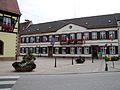
 La Laub, former town hall, now a museum | |
 Coat of arms | |
Location of Bischwiller  | |
 Bischwiller  Bischwiller | |
| Coordinates: 48°46′00″N 7°51′27″E / 48.7667°N 7.857500°E | |
| Country | France |
| Region | Grand Est |
| Department | Bas-Rhin |
| Arrondissement | Haguenau-Wissembourg |
| Canton | Bischwiller |
| Intercommunality | CA Haguenau |
| Government | |
| • Mayor (2020–2026) | Jean-Lucien Netzer[1] |
Area 1 | 17.25 km2 (6.66 sq mi) |
| Population (2021)[2] | 12,435 |
| • Density | 720/km2 (1,900/sq mi) |
| Time zone | UTC+01:00 (CET) |
| • Summer (DST) | UTC+02:00 (CEST) |
| INSEE/Postal code | 67046 /67240 |
| Elevation | 123–147 m (404–482 ft) |
| 1 French Land Register data, which excludes lakes, ponds, glaciers > 1 km2 (0.386 sq mi or 247 acres) and river estuaries. | |
Bischwiller (French pronunciation: [biʃvilɛʁ] ; German: Bischweiler; Alsatian: Bíschwiller)[a] is a commune in the Bas-Rhin department in Grand Est in northeastern France,[4] just west of the river Moder.
Geography
[edit]The city is 7.8 kilometers (4.8 mi) southeast of Haguenau, 8 kilometers (5.0 mi) west-northwest of the German border and the Rhine (Rhin), and lies 22 kilometers (14 mi) north-northeast of Strasbourg.
The Moder, a Rhine tributary, flows across the town. Among the other streams which cross the area can be cited the following tributaries of the Moder: the Rothbaechel, the Erlengraben and the Waschgraben. The last one is formed by the confluence of two smaller streams named Weihergraben and Schnuchgraben.
Population
[edit]Due to its large Turkish minority, Bischwiller has been pejoratively dubbed "Turcwiller" or "Bischtanbul".[5]
|
| ||||||||||||||||||||||||||||||||||||||||||||||||||||||||||||||||||||||||||||||||||||||||||||||||||||||||||||||||||
| |||||||||||||||||||||||||||||||||||||||||||||||||||||||||||||||||||||||||||||||||||||||||||||||||||||||||||||||||||
| Source: EHESS[6] and INSEE (1968-2017)[7] | |||||||||||||||||||||||||||||||||||||||||||||||||||||||||||||||||||||||||||||||||||||||||||||||||||||||||||||||||||
Culture
[edit]Personalities
[edit]- Henri Baumer, master carpenter
- Claude Vigée, poet
- Jacob Kirkman and Abraham Kirkman, harpsichord makers
- Jean Daum, glassware manufacturer
- Lucien Muller, footballer
- Otto Meißner, German politician
- Christian Goodnight (born Christian Gutknecht) is a direct-line ancestor of former U.S. President Barack Obama.[8][9][10][11]
Photo gallery
[edit]-
 Ancient timber-framed pharmacy
 -
 Saint-Augustin church
 -
 Bischwiller town hall
 -
 Protestant temple: tombstone of John I, Count Palatine of Zweibrücken (died in 1604) tombstone


See also
[edit]Notes
[edit]- ^ "Répertoire national des élus: les maires". data.gouv.fr, Plateforme ouverte des données publiques françaises (in French). 2 December 2020.
- ^ "Populations légales 2021" (in French). The National Institute of Statistics and Economic Studies. 28 December 2023.
- ^ Rapp 1823, pp. 365–366.
- ^ INSEE commune file
- ^ Gasparini, William; Koebel, Michel (2017). "Le football communautaire : enquête dans les clubs alsaciens, France". Sciences de la société. 101 (101): 144–167. doi:10.4000/sds.6469.
- ^ Des villages de Cassini aux communes d'aujourd'hui: Commune data sheet Bischwiller, EHESS (in French).
- ^ Population en historique depuis 1968, INSEE
- ^ Forek, Scott (September 9, 2007). "Christian Gutnecht-Goodnight: 'The dark and bloody ground'". Chicago Sun-Times. Archived from the original on March 4, 2009. Retrieved March 20, 2009.
- ^ Neue Zürcher Zeitung 24 juillet 2008, Die Zeit of the same day, and Zeitmagazin Leben 24.7.2008, N.31, p.14-15 (the article in the Zeitmagazin contains a complete genealogy of Barack Obama)
- ^ "Obama's forefathers include Swiss immigrant: archivist". Agence France-Presse. September 24, 2008.
- ^ Harneis, Robert (January 20, 2009). "Goodnight Mr. President". French News. Archived from the original on January 31, 2009. Retrieved March 20, 2009.
References
[edit]- Rapp, comte Jean (1823), Memoirs of General Count Rapp: First Aide-de-camp to Napoleon, H. Colburn and Company
External links
[edit]- Official website (in French)
| International | |
|---|---|
| National | |
| Geographic | |
| Other | |
This Bas-Rhin geographical article is a stub. You can help Wikipedia by expanding it. |
 EncycloReader
is supported by the
EncycloReader
is supported by the