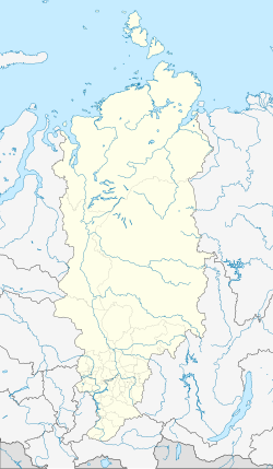
Bor, Turukhansky District, Krasnoyarsk Krai
 From Wikipedia - Reading time: 5 min
You can help expand this article with text translated from the corresponding article in Russian. (January 2025) Click [show] for important translation instructions.
|
Bor
Бор | |
|---|---|
Settlement | |
| Coordinates: 61°36′N 90°01′E / 61.600°N 90.017°E | |
| Country | Russia |
| Federal subject | Krasnoyarsk Krai |
| Administrative district | Turukhansky District |
| Population | |
• Total | 2,496 |
| Time zone | UTC+7 (MSK+4 |
| Postal code(s)[3] | |
| Dialing code(s) | +7 39110 |
| OKTMO ID | 04654404101 |
Bor (Russian: Бор) is a rural locality (a settlement) in Turukhansky District of Krasnoyarsk Krai, Russia, located on the Yenisei River just downstream of its confluence with the Podkamennaya Tunguska.
Geography
[edit]Bor stands directly opposite the village of Podkamennaya Tunguska on the other side of the Yenisei River.
Transportation
[edit]Bor is served by the Podkamennaya Tunguska Airport.[4]
Climate
[edit]Bor has a subarctic climate (Köppen climate classification Dfc). Winters are severely cold with average temperatures from −28.3 to −19.2 °C (−18.9 to −2.6 °F) in January, while summers are warm with average temperatures from +12.0 to +24.8 °C (53.6 to 76.6 °F) in July. Precipitation is moderate and is somewhat higher in summer and autumn than at other times of the year.
| Climate data for Bor | |||||||||||||
|---|---|---|---|---|---|---|---|---|---|---|---|---|---|
| Month | Jan | Feb | Mar | Apr | May | Jun | Jul | Aug | Sep | Oct | Nov | Dec | Year |
| Record high °C (°F) | 1.6 (34.9) |
4.4 (39.9) |
14.5 (58.1) |
24.9 (76.8) |
33.6 (92.5) |
35.0 (95.0) |
36.4 (97.5) |
33.5 (92.3) |
29.4 (84.9) |
21.6 (70.9) |
7.2 (45.0) |
3.6 (38.5) |
36.4 (97.5) |
| Mean daily maximum °C (°F) | −18.9 (−2.0) |
−13.8 (7.2) |
−3.3 (26.1) |
4.9 (40.8) |
12.4 (54.3) |
22.0 (71.6) |
24.9 (76.8) |
20.2 (68.4) |
11.7 (53.1) |
1.6 (34.9) |
−10.9 (12.4) |
−17.5 (0.5) |
2.8 (37.0) |
| Daily mean °C (°F) | −23.3 (−9.9) |
−19.2 (−2.6) |
−9.6 (14.7) |
−1.3 (29.7) |
5.9 (42.6) |
15.2 (59.4) |
18.3 (64.9) |
14.3 (57.7) |
7.0 (44.6) |
−1.6 (29.1) |
−14.6 (5.7) |
−21.5 (−6.7) |
−2.5 (27.4) |
| Mean daily minimum °C (°F) | −27.6 (−17.7) |
−24.1 (−11.4) |
−15.5 (4.1) |
−6.9 (19.6) |
0.2 (32.4) |
8.7 (47.7) |
12.3 (54.1) |
9.4 (48.9) |
3.3 (37.9) |
−4.4 (24.1) |
−18.3 (−0.9) |
−25.6 (−14.1) |
−7.4 (18.7) |
| Record low °C (°F) | −56.0 (−68.8) |
−52.9 (−63.2) |
−45.1 (−49.2) |
−36.6 (−33.9) |
−22.5 (−8.5) |
−7.0 (19.4) |
0.7 (33.3) |
−3.7 (25.3) |
−11.8 (10.8) |
−32.4 (−26.3) |
−52.7 (−62.9) |
−54.3 (−65.7) |
−56.0 (−68.8) |
| Average precipitation mm (inches) | 39 (1.5) |
29 (1.1) |
26 (1.0) |
32 (1.3) |
47 (1.9) |
58 (2.3) |
64 (2.5) |
70 (2.8) |
65 (2.6) |
62 (2.4) |
55 (2.2) |
47 (1.9) |
594 (23.5) |
| Average snowfall cm (inches) | 75 (30) |
86 (34) |
89 (35) |
68 (27) |
12 (4.7) |
0.1 (0.0) |
0 (0) |
0 (0) |
1 (0.4) |
5 (2.0) |
29 (11) |
54 (21) |
419.1 (165.1) |
| Average rainy days | 0.1 | 0.1 | 1 | 8 | 16 | 18 | 16 | 17 | 15 | 12 | 2 | 0.2 | 105.4 |
| Average snowy days | 26 | 23 | 19 | 11 | 3 | 0.1 | 0 | 0 | 1 | 13 | 24 | 27 | 147.1 |
| Average relative humidity (%) | 80 | 79 | 73 | 65 | 64 | 67 | 71 | 78 | 82 | 83 | 84 | 81 | 76 |
| Mean monthly sunshine hours | 26 | 83 | 152 | 201 | 225 | 269 | 299 | 207 | 108 | 55 | 32 | 11 | 1,668 |
| Source 1: pogoda.ru.net[5] | |||||||||||||
| Source 2: NOAA (sun only, 1961-1990)[6] | |||||||||||||
References
[edit]- ^ Russian Federal State Statistics Service (2011). Всероссийская перепись населения 2010 года. Том 1 [2010 All-Russian Population Census, vol. 1]. Всероссийская перепись населения 2010 года [2010 All-Russia Population Census] (in Russian). Federal State Statistics Service.
- ^ "Об исчислении времени". Официальный интернет-портал правовой информации (in Russian). June 3, 2011. Retrieved January 19, 2019.
- ^ Почта России. Информационно-вычислительный центр ОАСУ РПО. (Russian Post). Поиск объектов почтовой связи (Postal Objects Search) (in Russian)
- ^ "Podkamennaya Tunguska Airport". OurAirports. Retrieved January 19, 2013.
- ^ "Weather And Climate - Climate Bor" (in Russian). Retrieved January 19, 2013.
- ^ "Climate Normals for Bor". National Oceanic and Atmospheric Administration (FTP). Retrieved January 19, 2013. (To view documents see Help:FTP)
Licensed under CC BY-SA 3.0 | Source: https://en.wikipedia.org/wiki/Bor,_Turukhansky_District,_Krasnoyarsk_Krai1 | Status: cached on August 17 2025 07:44:32↧ Download as ZWI file
 KSF
KSF


