Brombach (Mümling)
 From Wikipedia - Reading time: 5 min
You can help expand this article with text translated from the corresponding article in German. (October 2018) Click [show] for important translation instructions.
|
| Brombach | |
|---|---|
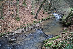
 The Brombach near Zell im Odenwald | |
 | |
| Location | |
| Country | Germany |
| State | Hesse |
| Physical characteristics | |
| Source | |
| • location | West of Rehbach (a district of Michelstadt) and Langen-Brombach (a district of Brombachtal) |
| • coordinates | 49°42′31″N 8°55′31″E / 49.7086°N 8.9254°E |
| Mouth | |
• location | In Zell im Odenwald (a district of Bad König) |
• coordinates | 49°43′26″N 8°59′37″E / 49.7240°N 8.9937°E |
| Basin features | |
| Progression | Mümling→ Main→ Rhine→ North Sea |
The Brombach is a six-kilometer-long river of Hesse, Germany.
The Brombach springs from several sources west of Rehbach (a district of Michelstadt) and of Langen-Brombach (a district of Brombachtal).[1] In the district Zell im Odenwald of Bad König, it discharges into the Mümling on the left bank.[2]
See also
[edit]References
[edit]- ^ "Brombach sources" (Map). Google Maps. Retrieved 1 November 2018.
- ^ "Brombach mouth" (Map). Google Maps. Retrieved 1 November 2018.
Licensed under CC BY-SA 3.0 | Source: https://en.wikipedia.org/wiki/Brombach_(Mümling)40 views | Status: cached on August 12 2025 06:58:40↧ Download as ZWI file
 KSF
KSF