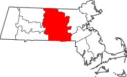
Brookfield (CDP), Massachusetts
 From Wikipedia - Reading time: 7 min
Brookfield, Massachusetts | |
|---|---|
 Town Hall | |
| Coordinates: 42°12′58″N 72°6′10″W / 42.21611°N 72.10278°W | |
| Country | |
| State | Massachusetts |
| County | Worcester |
| Town | Brookfield |
| Area | |
• Total | 1.15 sq mi (2.98 km2) |
| • Land | 1.15 sq mi (2.98 km2) |
| • Water | 0.00 sq mi (0.00 km2) |
| Elevation | 696 ft (212 m) |
| Population (2020) | |
• Total | 824 |
| • Density | 715.28/sq mi (276.09/km2) |
| Time zone | UTC-5 (Eastern (EST)) |
| • Summer (DST) | UTC-4 (EDT) |
| ZIP Code | 01506 |
| Area code(s) | 508/774 |
| FIPS code | 25-09070 |
| GNIS feature ID | 2630524[2] |
Brookfield is a census-designated place (CDP) comprising the main village in the town of Brookfield, Worcester County, Massachusetts, United States. Massachusetts Route 9 passes through the center of the village, leading east 6 miles (10 km) to Spencer and west 9 miles (14 km) to Ware. Massachusetts Route 148 crosses Route 9 in the village center, leading north 4 miles (6 km) to North Brookfield and south 7 miles (11 km) to Fiskdale.
Brookfield was first listed as a CDP after the 2010 census.[2]
Demographics
[edit]| Census | Pop. | Note | %± |
|---|---|---|---|
| 2020 | 824 | — | |
| U.S. Decennial Census[3] | |||
References
[edit]- ^ "2020 U.S. Gazetteer Files". United States Census Bureau. Retrieved May 21, 2022.
- ^ a b c "Brookfield Census Designated Place". Geographic Names Information System. United States Geological Survey, United States Department of the Interior.
- ^ "Census of Population and Housing". Census.gov. Retrieved June 4, 2016.
Licensed under CC BY-SA 3.0 | Source: https://en.wikipedia.org/wiki/Brookfield_(CDP),_Massachusetts8 views | Status: cached on May 08 2025 05:33:41↧ Download as ZWI file
 KSF
KSF

