Cairon
 From Wikipedia - Reading time: 10 min
You can help expand this article with text translated from the corresponding article in French. (December 2008) Click [show] for important translation instructions.
|
Cairon | |
|---|---|
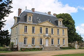
 Chateau | |
| Coordinates: 49°14′28″N 0°26′56″W / 49.2411°N 0.4489°W | |
| Country | France |
| Region | Normandy |
| Department | Calvados |
| Arrondissement | Caen |
| Canton | Thue et Mue |
| Intercommunality | CU Caen la Mer |
| Government | |
| • Mayor (2020–2026) | Dominique Rouzic[1] |
Area 1 | 5.91 km2 (2.28 sq mi) |
| Population (2021)[2] | 2,023 |
| • Density | 340/km2 (890/sq mi) |
| Time zone | UTC+01:00 (CET) |
| • Summer (DST) | UTC+02:00 (CEST) |
| INSEE/Postal code | 14123 /14610 |
| Elevation | 28–72 m (92–236 ft) (avg. 85 m or 279 ft) |
| 1 French Land Register data, which excludes lakes, ponds, glaciers > 1 km2 (0.386 sq mi or 247 acres) and river estuaries. | |
Cairon (French pronunciation: [kɛʁɔ̃] ) is a commune in the Calvados department in the Normandy region in northwestern France.
Geography
[edit]The commune of Cairon is situated in Normandy, in Calvados, 5 kilometers to the north-west of Caen.
The Mue river and its tributary the Vey flow through Cairon.
Toponymy
[edit]Cairon, Karon in 1077 and Cayron in 1231:[3] the toponym was probably formed from the Gallo-Roman Carius by adding the suffix -onis.[4]
History
[edit]During the Invasion of Normandy, Cairon was liberated on 11 June 1944 by the 46th Royal Marine Commando.
The demonym (previously gentilic) is Caironnais.
Population
[edit]In 2015, the commune totaled 1,947 inhabitants, a growth of 21% compared to 2010 (Calvados: +1.53%, France outside Mayotte: +2.44%).
| Year | Pop. | ±% p.a. |
|---|---|---|
| 1968 | 480 | — |
| 1975 | 664 | +4.74% |
| 1982 | 809 | +2.86% |
| 1990 | 1,098 | +3.89% |
| 1999 | 1,585 | +4.16% |
| 2007 | 1,573 | −0.09% |
| 2012 | 1,759 | +2.26% |
| 2017 | 1,987 | +2.47% |
| Source: INSEE[5] | ||
See also
[edit]- Communes of the Calvados department
- Buron
- Jean-Luc Cairon (born 1962), French gymnast and coach
References
[edit]- ^ "Répertoire national des élus: les maires" (in French). data.gouv.fr, Plateforme ouverte des données publiques françaises. 13 September 2022.
- ^ "Populations légales 2021" (in French). The National Institute of Statistics and Economic Studies. 28 December 2023.
- ^ Albert Dauzat and Charles Rostaing, Dictionnaire étymologique des noms de lieux en France, Paris, Larousse, 1963
- ^ René Lepelley, Dictionnaire étymologique des noms de communes de Normandie, Condé-sur-Noireau, Éd. Charles Corlet, 1996 (ISBN 2-95480-455-4, notice BnFno FRBNF36174448), p. 83
- ^ Population en historique depuis 1968, INSEE
Wikimedia Commons has media related to Cairon.
Licensed under CC BY-SA 3.0 | Source: https://en.wikipedia.org/wiki/Cairon12 views | Status: cached on November 24 2024 14:23:49↧ Download as ZWI file
 KSF
KSF


