Cat Cays Airport
 From Wikipedia - Reading time: 6 min
Cat Cay Airport | |||||||||||
|---|---|---|---|---|---|---|---|---|---|---|---|
| Summary | |||||||||||
| Airport type | PRIVATE | ||||||||||
| Serves | North Cat Cay | ||||||||||
| Location | Bahamas | ||||||||||
| Elevation AMSL | 0 ft / 0 m | ||||||||||
| Coordinates | 25°33′19.0″N 79°16′33.8″W / 25.555278°N 79.276056°W | ||||||||||
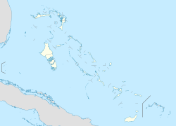
| Map | |||||||||||
 | |||||||||||
| Runways | |||||||||||
| |||||||||||
Cat Cay Airport (IATA: CXY, ICAO: MYCC) is a private airport located on North Cat Cay, the Bahamas. The airport is for the exclusive use of the Cat Cay Yacht Club and requires you to either be a member, or be sponsored by a member to land. The airport is served by Tropic Ocean Airways on a charter basis or by Fly the Whale in the winter, also on a charter basis.
See also
[edit]References
[edit]- ^ Airport record for Cat Cay Airport at Landings.com. Retrieved 2013-08-08
- ^ "location of Cat Cay Airport" (Map). Google Maps. Retrieved 2013-08-08.
External links
[edit]- Airport record for Cat Cay Airport at Landings.com
- Fly The Whale Charter Flights into Cat Cay
- Tropic Ocean Airways Charter Flights into Cat Cay
Licensed under CC BY-SA 3.0 | Source: https://en.wikipedia.org/wiki/Cat_Cays_Airport60 views | Status: cached on August 12 2025 13:40:43↧ Download as ZWI file
 KSF
KSF