Cheshire Village, Connecticut
 From Wikipedia - Reading time: 6 min
Cheshire Village, Connecticut | |
|---|---|
 First Congregational Church | |
| Coordinates: 41°30′0″N 72°54′3″W / 41.50000°N 72.90083°W | |
| Country | |
| State | Connecticut |
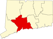
| County | New Haven |
| Town | Cheshire |
| Area | |
• Total | 10.36 km2 (4.00 sq mi) |
| • Land | 10.36 km2 (4.00 sq mi) |
| • Water | 0.0 km2 (0.0 sq mi) |
| Elevation | 81 m (266 ft) |
| Population | |
• Total | 5,786 |
| • Density | 558.2/km2 (1,446/sq mi) |
| Time zone | UTC-5 (Eastern (EST)) |
| • Summer (DST) | UTC-4 (EDT) |
| ZIP Code | 06410 (Cheshire) |
| Area code(s) | 203/475 |
| FIPS code | 09-14200 |
| GNIS feature ID | 2378345[2] |
Cheshire Village is a census-designated place (CDP) comprising the primary village and adjacent residential land in the town of Cheshire, New Haven County, Connecticut, United States. It is in the center of the town, surrounding the intersections of Connecticut Routes 10, 70, and 68.
As of the 2010 census, the CDP had a population of 5,786,[3] out of 29,261 in the entire town of Cheshire.
References
[edit]- ^ "2020 U.S. Gazetteer Files – Connecticut". United States Census Bureau. Retrieved April 14, 2021.
- ^ a b "Cheshire Village Census Designated Place". Geographic Names Information System. United States Geological Survey, United States Department of the Interior.
- ^ a b "Total Population: 2010 Census DEC Summary File 1 (P1), Cheshire Village CDP, Connecticut". data.census.gov. U.S. Census Bureau. Retrieved April 14, 2021.
Licensed under CC BY-SA 3.0 | Source: https://en.wikipedia.org/wiki/Cheshire_Village,_Connecticut10 views | Status: cached on December 02 2024 14:32:52↧ Download as ZWI file
 KSF
KSF

