Columbus Municipal Airport (Indiana)
 From Wikipedia - Reading time: 6 min
Columbus Municipal Airport | |||||||||||||||
|---|---|---|---|---|---|---|---|---|---|---|---|---|---|---|---|
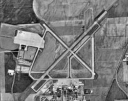
 USGS photo - 7 Aug 1997 | |||||||||||||||
 FAA diagram | |||||||||||||||
| Summary | |||||||||||||||
| Airport type | Public | ||||||||||||||
| Owner | City of Columbus | ||||||||||||||
| Location | Columbus, Indiana | ||||||||||||||
| Elevation AMSL | 656 ft / 200 m | ||||||||||||||
| Coordinates | 39°15′43″N 085°53′47″W / 39.26194°N 85.89639°W | ||||||||||||||
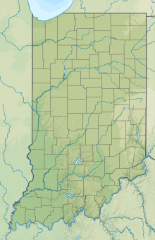
| Map | |||||||||||||||
 | |||||||||||||||
| Runways | |||||||||||||||
| |||||||||||||||
| Statistics | |||||||||||||||
| |||||||||||||||
- For the military use of this facility, see Bakalar Air Force Base.
Columbus Municipal Airport (IATA: CLU, ICAO: KBAK, FAA LID: BAK) is three miles north of Columbus, in Bartholomew County, Indiana, United States.[1]
Most U.S. airports use the same three-letter location identifier for the FAA and IATA, but this airport is BAK to the FAA and CLU to the IATA.[2]

History
[edit]The airport is on the site of the former World War II Atterbury Army Airfield, a U.S. Army Air Forces facility, and Bakalar Air Force Base, a Cold War-era U.S. Air Force installation utilized primarily by the Air Force Reserve. It was the host base for the 434th Troop Carrier Wing twice, from 1949 to 1952 and again from 1953 to 1969.
A Douglas DC-3 at the airport was destroyed in a wind storm in May 2022.[3]
Facilities
[edit]Columbus Municipal Airport covers 2,000 acres (810 ha) at an elevation of 656 feet (200 m). It has two concrete runways: 5/23 is 6,400 by 150 feet (1,951 x 46 m) and 14/32 is 5,000 by 100 feet (1,524 x 30 m).[1]
In 2005 the airport had 39,155 aircraft operations, average 107 per day: 91% general aviation and 9% military. In 2015, 77 aircraft were based at the airport: 58 single-engine, 8 multi-engine, 7 jet, 2 helicopter, 1 glider and 1 ultra-light.[1]
The Atterbury-Bakalar Air Museum is located at the airport.
Terminal
[edit]The airport completely renovated its terminal building in 2015.
See also
[edit]References
[edit]- ^ a b c d FAA Airport Form 5010 for BAK PDF, effective 2009-05-07.
- ^ "CLU - Columbus [Muni], IN, US - Airport - Great Circle Mapper". gc.kls2.com.
- ^ Ryan, Haley (22 June 2022). "Damaged Columbus aircraft to be surplus equipment and auctioned off". Indiana Public Media. Retrieved 11 December 2023.
External links
[edit] Media related to Columbus Municipal Airport at Wikimedia Commons
- Columbus Municipal Airport
- Aerial photo from Indiana Department of Transportation
- FAA Airport Diagram for Columbus Municipal (BAK) (PDF), effective October 31, 2024
- FAA Terminal Procedures for Columbus Municipal (BAK), effective October 31, 2024
- Resources for this airport:
- FAA airport information for BAK
- AirNav airport information for KBAK
- ASN accident history for CLU
- FlightAware airport information and live flight tracker
- NOAA/NWS weather observations: current, past three days
- SkyVector aeronautical chart, Terminal Procedures
 KSF
KSF
