Categories
Cottonwood, Coal County, Oklahoma
 From Wikipedia - Reading time: 5 min
Cottonwood, Oklahoma | |
|---|---|
 Cottonwood Location within the state of Oklahoma  Cottonwood Cottonwood (the United States) | |
| Coordinates: 34°33′14″N 96°12′14″W / 34.55389°N 96.20389°W | |
| Country | United States |
| State | Oklahoma |
| County | Coal |
| Elevation | 584 ft (178 m) |
| Time zone | UTC-6 (Central (CST)) |
| • Summer (DST) | UTC-5 (CDT) |
| GNIS feature ID | 2805312[1] |
Cottonwood is an unincorporated community in Coal County, Oklahoma, United States.[1] It is located two miles northeast of Coalgate.[2] A post office operated in Cottonwood from April 1, 1914 to December 31, 1914.[2]
References
[edit]Municipalities and communities of Coal County, Oklahoma, United States | ||
|---|---|---|
| Cities | 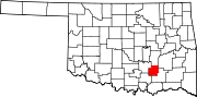 | |
| Towns | ||
| CDPs | ||
| Other communities | ||
| Indian reservations | ||
| Footnotes | ‡This populated place also has portions in an adjacent county or counties | |
This Oklahoma state location article is a stub. You can help Wikipedia by expanding it. |
Licensed under CC BY-SA 3.0 | Source: https://en.wikipedia.org/wiki/Cottonwood,_Coal_County,_Oklahoma13 views | Status: cached on November 24 2024 01:12:37↧ Download as ZWI file
 EncycloReader
is supported by the
EncycloReader
is supported by the